フリーワード アプリケーション検索
221件が見つかりました。23ページ中7ページ目を表示しています。
 2人 [ ライフスタイル ]
|

Quickgets Geo v3.0
• «Best new apps» AppStore app featured in 17 countries on iOS8 launch day, featuring Apple Watch support.
• App featured on Yahoo Tech, AppAdvice, BGR, AppPicker, iPhon.fr...
With Quickgets Geo you can quickly get the course in which you are, current speed, altitude, geographical coordinates, orientation and weather indicators by using the internal compass and GPS. As a new feature, now Quickgets Geo supports advanced bookmarking, Street View and Flyover live mapping of current position, multiple units, distan...
 2人 [ ナビゲーション ]
|

A coordinate utility app that calculates the distance and initial/final bearings between two points on Earth specified either manually by latitude and longitude or automatically using the built-in map. It can also calculate a final position given an initial position, distance, and bearing.
################################
Limited time sale, get it now before the
price increase to $4.99
################################
The final distance can be calculated in miles, kilometers, nautical miles, yards, meters, or feet. Coordinates...
 2人 [ ナビゲーション ]
|

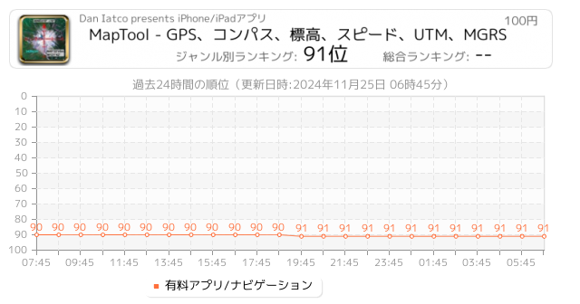
A must have toolkit for every outdoor enthusiast: climber, hiker, off-road driver. All the essential tools for navigation are integrated seamlessly in one app.
MapTool combines full screen map, GPS, compass, altitude, UTM, Magnetic declination, precision grid and more.
GPS with COMPASS
Both GPS and Compass are displayed on the map with a high precision grid. Accuracy (±) is indicated to check signal quality or magnetic interference.
ALTITUDE
Current altitude is displayed with accuracy (±) in GPS mode.
SPEED
Current speed ...
 1人 [ ユーティリティ ]
|

簡単に地図に半径を作成および任意のブラウザーで閲覧することができます電子メールやテキスト メッセージを介して半径を示す url を共有します。
フルバージョンの追加機能が含まれています:
- 半径の中心を現在の位置にロックします。
- 風景と iPad のサポートは分割画面です。
- 1 つの url で複数の半径を共有します。
- 半径 .kml または .kmz ファイル内のポリゴンとして保存をインポートします。 ICloud や Dropbox などのクラウド サービスからファイルをインポートすることができます。
- ポリゴン Google Earth™ または他のマッピング アプリケーションで表示する k...
|
1人 [ ナビゲーション ]
|

Hikers and climbers can now access real full-resolution USGS topographic 1:24k quads with side-scrolling multi-zoom map capabilities.
In addition, quads can be graphically selected for storage on the device for access where you need it most, away from cellular and WiFi coverage!
Current Map and GPS positions are available in latitude/longitude and UTM coordinate systems. NAD27 and NAD83 are supported.
Available Map Sources:
USGS (United States and borders)
Toporama (Canada)
OpenCycleMap (World)
OpenStreetMap (World)
11...

 1人 [ 天気 ]
|

Great for hikers, photographers, astronomers, pilots, sailors, ham radio operators, or for anyone that wants more information than a basic weather app.
Features:
• Astronomical, Nautical, and Civil sunlight times. Golden Hour. Hours/Minutes of daylight. Minutes and Seconds of daylight gained/lost each day. Times calculated for any date.
• Moon Phase along with detailed moon phase information, including find a moon phase for any date since January 6, 1900.
• Maidenhead coordinates for ham radio operators.
• Military Time Zones.
...
|
1人 [ ナビゲーション ]
|

* View over 70,000 USGS and Canadian topographical maps on your iPhone or iPod touch. * Ideal for hiking and other backcountry activities. * Map downloads are FREE! * More than 16 million maps downloaded so far!
- iPad owners, please see the app "Topo Maps for iPad".
* Users write:
" I've bought all the topo map apps and I like this the best "
" Scans are gorgeous ... the interface is exceptionally clean "
" Downloading maps is easy and fast ... Map displays beautifully and zooms flawlessly "
* Includes Alaska (at 1:2...
|
1人 [ ナビゲーション ]
|

Beautifully detailed maps supplied by Ordnance Survey.
As featured in Ordnance Survey's OS OpenData innovative application showcase.
A 1:250K scale map of GB is included with the app.
The following 1:25K map In App Purchases are available at competitive prices: -
- Ben Nevis & Glen Coe
- Brecon Beacons
- Cairngorms
- Dartmoor
- Exmoor
- Fylde (Free)
- Lake District
- Loch Lomond
- New Forest
- North York Moors
- Northumberland (National Park)
- Peak District
- Pembrokeshire
- Snowdonia
- South Downs
- The Broads
- Yorkshire Da...
|
[ エンターテインメント ]
|

サイエンスフィクションのルックアンドフィールをお使いの携帯電話のセンサからの情報が表示され、REAL 、対話型スキャナ。このスキャナは、 9統合モジュールがあります:太陽は、ジオは、天気、オーディオ、ジャイロ、マグ、 GPS、カム、デバイスが、自由であるそのうちの3つ。すべてのiPhoneやiPad上でフルHDグラフィックス。ここで、ノード+ 7追加のモジュールを搭載した無線センサーをサポートしています!
太陽電池モジュール
米国のACE衛星から太陽風プラズマの測定値の最後の96時間をグラフ化し、最新の太陽X線が表示されます。測定されたパラメータは、プロトン密度、...
Now Loading...

「iPhone & iPad アプリランキング」は、最新かつ詳細なアプリ情報をご紹介しているサイトです。
お探しのアプリに出会えるように様々な切り口でページをご用意しております。
「メニュー」よりぜひアプリ探しにお役立て下さい。
Presents by $$308413110 スマホからのアクセスにはQRコードをご活用ください。 →
Now loading...