マップ完全版上の半径 |


|
価格 | 900円 | ダウンロード |
|
|---|---|---|---|---|
| ジャンル | ユーティリティ | |||
サイズ | 6.3MB | |||
| 開発者 | TappiApps | |||
| 順位 |
| |||
| リリース日 | 2015-05-31 12:00:29 | 評価 |
|
|
| 互換性 | iOS 9.0以降が必要です。 iPhone、iPad および iPod touch 対応。 | |||
 (1人)
(1人)
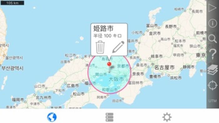
簡単に地図に半径を作成および任意のブラウザーで閲覧することができます電子メールやテキスト メッセージを介して半径を示す url を共有します。
フルバージョンの追加機能が含まれています:
- 半径の中心を現在の位置にロックします。
- 風景と iPad のサポートは分割画面です。
- 1 つの url で複数の半径を共有します。
- 半径 .kml または .kmz ファイル内のポリゴンとして保存をインポートします。 ICloud や Dropbox などのクラウド サービスからファイルをインポートすることができます。
- ポリゴン Google Earth™ または他のマッピング アプリケーションで表示する kml ファイルに保存としてあなたの半径をエクスポートします。 .Kml ファイルを電子メールに添付したり、Dropbox が、iCloud に保存など。
- リストビューで選択してマップ上に表示する半径を指定する機能。
- 特定の半径を見つけるために、名前やメモフィールドでキーワードを検索します。
- カスタム メッセージ ヘッダーとフッター。
- いいえ広告
各 radius のプロパティ:
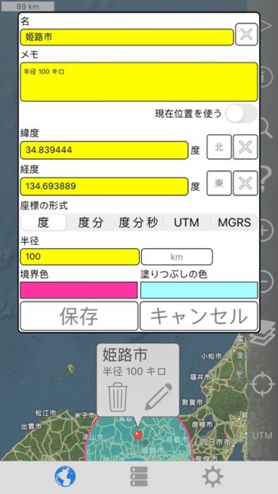
- 中心座標
- 半径
- 塗りつぶしの色および不透明度
- 境界色と不透明度
- 名前
- ノート (オプション)
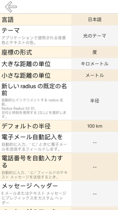
座標フォーマットがあります。
- 度
- 度、分
- 度、分、秒
- UTM (ユニバーサル横メルカトル)
- MGRS (ミリタリーグリッドリファレンスシステム)
距離の単位が含まれます。
- キロ
- マイル
- 海里
- メートル
- ヤード
- フィート
衛星マップをロードには、インターネット接続が必要です。
使用されるデータムは、WGS 84 です。
詳細については、サポート ページをご覧ください。
English:
Easily make a radius on a map and share a url showing the radius via email or text message that can be viewed with any browser.
Extra functionality of the full version includes:
- Lock a radius center to your current location.
- Support for landscape and iPad split screen.
- Share multiple radii in one url.
- Import radii stored as polygons in a .kml or .kmz file. You can import a file from a cloud service such as iCloud or Dropbox.
- Export your radii as polygons saved to a kml file to view in Google Earth™ or other mapping applications. You can attach the .kml file to an email or save to iCloud, Dropbox, etc.
- Ability to specify which radii show on the map by selecting them in the list view.
- Search for keywords in name and/or notes field to find a specific radius.
- Custom message header and footer.
- No adverts
Properties for each radius:
- Center coordinate
- Radius
- Fill color and opacity
- Perimeter color and opacity
- Name
- Notes (optional)
Coordinate formats include:
- Degrees
- Degrees, Minutes
- Degrees, Minutes, Seconds
- UTM (Universal Transverse Mercator)
- MGRS (Military Grid Reference System)
Distance units include:
- Kilometers
- Miles
- Nautical miles
- Meters
- Yards
- Feet
Loading satellite maps requires an internet connection.
Datum used is WGS-84.
Please visit the support page for more details.
更新履歴
新しいバージョンのiOSの互換性修正。
English:
Compatibility fix for newer iOS versions.
Please send crash reports if crashes occur.
Please contact the developer via email if you have questions or notice any errors or issues.
フルバージョンの追加機能が含まれています:
- 半径の中心を現在の位置にロックします。
- 風景と iPad のサポートは分割画面です。
- 1 つの url で複数の半径を共有します。
- 半径 .kml または .kmz ファイル内のポリゴンとして保存をインポートします。 ICloud や Dropbox などのクラウド サービスからファイルをインポートすることができます。
- ポリゴン Google Earth™ または他のマッピング アプリケーションで表示する kml ファイルに保存としてあなたの半径をエクスポートします。 .Kml ファイルを電子メールに添付したり、Dropbox が、iCloud に保存など。
- リストビューで選択してマップ上に表示する半径を指定する機能。
- 特定の半径を見つけるために、名前やメモフィールドでキーワードを検索します。
- カスタム メッセージ ヘッダーとフッター。
- いいえ広告
各 radius のプロパティ:
- 中心座標
- 半径
- 塗りつぶしの色および不透明度
- 境界色と不透明度
- 名前
- ノート (オプション)
座標フォーマットがあります。
- 度
- 度、分
- 度、分、秒
- UTM (ユニバーサル横メルカトル)
- MGRS (ミリタリーグリッドリファレンスシステム)
距離の単位が含まれます。
- キロ
- マイル
- 海里
- メートル
- ヤード
- フィート
衛星マップをロードには、インターネット接続が必要です。
使用されるデータムは、WGS 84 です。
詳細については、サポート ページをご覧ください。
English:
Easily make a radius on a map and share a url showing the radius via email or text message that can be viewed with any browser.
Extra functionality of the full version includes:
- Lock a radius center to your current location.
- Support for landscape and iPad split screen.
- Share multiple radii in one url.
- Import radii stored as polygons in a .kml or .kmz file. You can import a file from a cloud service such as iCloud or Dropbox.
- Export your radii as polygons saved to a kml file to view in Google Earth™ or other mapping applications. You can attach the .kml file to an email or save to iCloud, Dropbox, etc.
- Ability to specify which radii show on the map by selecting them in the list view.
- Search for keywords in name and/or notes field to find a specific radius.
- Custom message header and footer.
- No adverts
Properties for each radius:
- Center coordinate
- Radius
- Fill color and opacity
- Perimeter color and opacity
- Name
- Notes (optional)
Coordinate formats include:
- Degrees
- Degrees, Minutes
- Degrees, Minutes, Seconds
- UTM (Universal Transverse Mercator)
- MGRS (Military Grid Reference System)
Distance units include:
- Kilometers
- Miles
- Nautical miles
- Meters
- Yards
- Feet
Loading satellite maps requires an internet connection.
Datum used is WGS-84.
Please visit the support page for more details.
更新履歴
新しいバージョンのiOSの互換性修正。
English:
Compatibility fix for newer iOS versions.
Please send crash reports if crashes occur.
Please contact the developer via email if you have questions or notice any errors or issues.
ブログパーツ第二弾を公開しました!ホームページでアプリの順位・価格・周辺ランキングをご紹介頂けます。
ブログパーツ第2弾!
アプリの周辺ランキングを表示するブログパーツです。価格・順位共に自動で最新情報に更新されるのでアプリの状態チェックにも最適です。
ランキング圏外の場合でも周辺ランキングの代わりに説明文を表示にするので安心です。
サンプルが気に入りましたら、下に表示されたHTMLタグをそのままページに貼り付けることでご利用頂けます。ただし、一般公開されているページでご使用頂かないと表示されませんのでご注意ください。
幅200px版
幅320px版
お気に入りのアプリをご紹介頂くためのブログパーツです。アプリの価格や順位表示は毎日自動更新♪
サンプルが気に入りましたら、下に表示されたHTMLタグをそのままページに貼り付けることでご利用頂けます。
※配信を停止させていただく可能性もございますので、タグの改変はご遠慮ください。

Now Loading...

「iPhone & iPad アプリランキング」は、最新かつ詳細なアプリ情報をご紹介しているサイトです。
お探しのアプリに出会えるように様々な切り口でページをご用意しております。
「メニュー」よりぜひアプリ探しにお役立て下さい。
Presents by $$308413110 スマホからのアクセスにはQRコードをご活用ください。 →
Now loading...