iTopoMaps |
| このアプリは現在ストアで閲覧することができません。 | ||||
|
価格 | 1200円 | ダウンロード |
|
|---|---|---|---|---|
| ジャンル | ナビゲーション | |||
サイズ | 15.8MB | |||
| 開発者 | Amphibious Technologies, LLC | |||
| 順位 |
| |||
| リリース日 | 2009-04-15 02:30:49 | 評価 |
|
|
| 互換性 | iOS 5.1.1以降が必要です。 iPhone、iPad および iPod touch 対応。 | |||
|
||||
 (1人)
(1人)
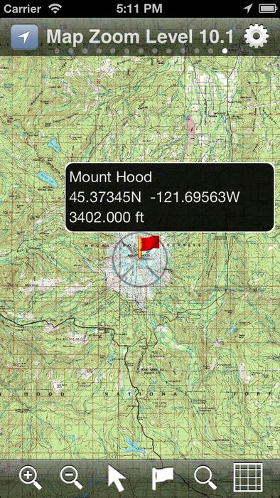
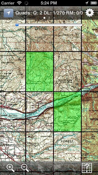
Hikers and climbers can now access real full-resolution USGS topographic 1:24k quads with side-scrolling multi-zoom map capabilities.
In addition, quads can be graphically selected for storage on the device for access where you need it most, away from cellular and WiFi coverage!
Current Map and GPS positions are available in latitude/longitude and UTM coordinate systems. NAD27 and NAD83 are supported.
Available Map Sources:
USGS (United States and borders)
Toporama (Canada)
OpenCycleMap (World)
OpenStreetMap (World)
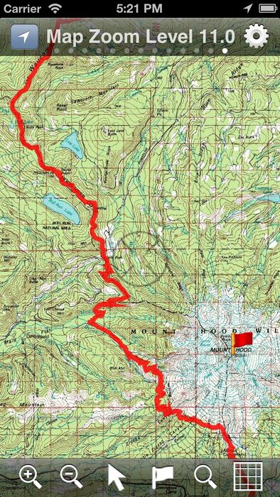
11 Zoom Levels are available to give full resolution quadrangles. Simply pinch to zoom in or out! Get in close for details, or zoom out to see your whole area!
Select quadrangles graphically just by double-tapping! No need to mess with coordinates or obscure quadrangle names.
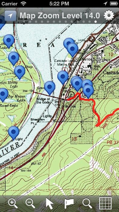
GNIS (Geographic Names Information Service) database included for Features of Interest lookup. Lookup features (summits, waterfalls, streams, etc) and add them as waypoints! No need to type in waypoints by hand. You can also search the database in an area and it will label all local features. ~700k entries available at the touch of a finger!
All 50 United States States included.
Features:
- Full Resolution 1:24k USGS Quads (1:63k in Alaska)
- UTM and latitude/longitude
- Meters and Feet
- NAD27 and NAD83 datums
- Cache maps on your phone!
- Display and record Tracks
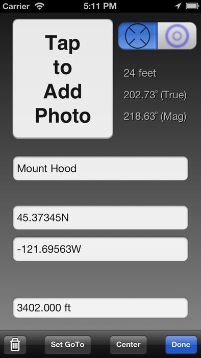
- Editable Waypoints - Just tap to place or lookup by name.
- Course and Speed
- Bearing / Distance to Waypoints
- Magnetic Declination Calculations
- Map works in portrait and landscape positions!
- GPS Location and Map following
- Look up GNIS locations from geographic formations (like Summits, Streams, Falls, Cliffs, etc) and add them as Waypoints. Have iTopoMaps label neighboring features!
When in Grid Mode, simply double tap an area to select a quad for download! Downloads happen in the background and can be restarted where you left out! Wifi/3G recommended for Quad downloads.
GPS is not required for map usage, but adds to navigation functionality.
New feature requests are always welcome! Join us at http://www.itopomaps.com
Some map data is provided by 3rd parties. Availability and coverage are not guaranteed.
Tags: GPS USGS Topo Topographics Quads Quadrangles WGS WGS84 UTM Waypoints Tracks GNIS Geographic declination
更新履歴
Fix for quad import via DropBox
In addition, quads can be graphically selected for storage on the device for access where you need it most, away from cellular and WiFi coverage!
Current Map and GPS positions are available in latitude/longitude and UTM coordinate systems. NAD27 and NAD83 are supported.
Available Map Sources:
USGS (United States and borders)
Toporama (Canada)
OpenCycleMap (World)
OpenStreetMap (World)
11 Zoom Levels are available to give full resolution quadrangles. Simply pinch to zoom in or out! Get in close for details, or zoom out to see your whole area!
Select quadrangles graphically just by double-tapping! No need to mess with coordinates or obscure quadrangle names.
GNIS (Geographic Names Information Service) database included for Features of Interest lookup. Lookup features (summits, waterfalls, streams, etc) and add them as waypoints! No need to type in waypoints by hand. You can also search the database in an area and it will label all local features. ~700k entries available at the touch of a finger!
All 50 United States States included.
Features:
- Full Resolution 1:24k USGS Quads (1:63k in Alaska)
- UTM and latitude/longitude
- Meters and Feet
- NAD27 and NAD83 datums
- Cache maps on your phone!
- Display and record Tracks
- Editable Waypoints - Just tap to place or lookup by name.
- Course and Speed
- Bearing / Distance to Waypoints
- Magnetic Declination Calculations
- Map works in portrait and landscape positions!
- GPS Location and Map following
- Look up GNIS locations from geographic formations (like Summits, Streams, Falls, Cliffs, etc) and add them as Waypoints. Have iTopoMaps label neighboring features!
When in Grid Mode, simply double tap an area to select a quad for download! Downloads happen in the background and can be restarted where you left out! Wifi/3G recommended for Quad downloads.
GPS is not required for map usage, but adds to navigation functionality.
New feature requests are always welcome! Join us at http://www.itopomaps.com
Some map data is provided by 3rd parties. Availability and coverage are not guaranteed.
Tags: GPS USGS Topo Topographics Quads Quadrangles WGS WGS84 UTM Waypoints Tracks GNIS Geographic declination
更新履歴
Fix for quad import via DropBox
ブログパーツ第二弾を公開しました!ホームページでアプリの順位・価格・周辺ランキングをご紹介頂けます。
ブログパーツ第2弾!
アプリの周辺ランキングを表示するブログパーツです。価格・順位共に自動で最新情報に更新されるのでアプリの状態チェックにも最適です。
ランキング圏外の場合でも周辺ランキングの代わりに説明文を表示にするので安心です。
サンプルが気に入りましたら、下に表示されたHTMLタグをそのままページに貼り付けることでご利用頂けます。ただし、一般公開されているページでご使用頂かないと表示されませんのでご注意ください。
幅200px版
幅320px版
お気に入りのアプリをご紹介頂くためのブログパーツです。アプリの価格や順位表示は毎日自動更新♪
サンプルが気に入りましたら、下に表示されたHTMLタグをそのままページに貼り付けることでご利用頂けます。
※配信を停止させていただく可能性もございますので、タグの改変はご遠慮ください。

Now Loading...

「iPhone & iPad アプリランキング」は、最新かつ詳細なアプリ情報をご紹介しているサイトです。
お探しのアプリに出会えるように様々な切り口でページをご用意しております。
「メニュー」よりぜひアプリ探しにお役立て下さい。
Presents by $$308413110 スマホからのアクセスにはQRコードをご活用ください。 →
Now loading...