フリーワード アプリケーション検索
6451件が見つかりました。646ページ中4ページ目を表示しています。
 6人 [ ナビゲーション ]
|

どこへ行っても数百ユーロ節約できる方法。
アップデートされた地図。ボイスナビゲーター。数百万の目的地。
拡張現実感で表示される道路標示。今すぐお試しください!
------------------------------------------------------------------------------------------
► 100%オフライン‐いつでもどこでも使えます。
‐インターネット接続必要なし。
‐国際ローミング支払いなし。
‐自国で使うと、データプランを節約できます。
►マルチ言語ボイスナビゲーター
‐ターンバイターンGPSボイスナビゲーション
‐目を道路から離さず、ターンバイターンGPSナビゲーションを利用しましょ...
 6人 [ ゲーム ]
|

Time to put away your birds and instead wheel out the heavy artillery! This MMO takes gamers' locations in the real world and throws them into a global conflict, where the aim is to launch missiles against other gamers' bases.
A global playground
Locate your enemies anywhere around the world using the radar. Thanks to the interactive world map with 12 zoom levels, you can pinpoint anyone anywhere!
Sending a missile has never been so easy: select a missile from the different ones available, position your sights over the world ...
 6人 [ 旅行 ]
|

Updated : All in One (iPad, iPhone4, iPhone3GS/3G, iTouch, iOS 4 compatible, Searching (street,restaurant,hotel,school,etc), Bookmarking, Parking, Search Filtering, Location tracking using Wifi, and much much more...)
Tokyo Map Offline enable you to use maps offline without internet connection. This includes maps street names detail. This will give peace of mind when traveling aboard knowing you will not be charged with roaming fee.
A lot of new features
- All in one search feature (street, restaurant, hotels, schools, etc)
- B...
 5人 [ 仕事効率化 ]
|

簡単に共有、電子メール、テキスト メッセージ、Twitter、Facebook、WhatsApp などあなたの GPS 場所を。 受信者は、それ上の位置とオンライン地図へのリンクを受け取ります。 よく屋根の下で GPS が動作しないことに注意してください。 最高の結果を得るには、屋外で使用します。
座標フォーマットがあります。
- 度
- 度、分
- 度、分、秒
- UTM (ユニバーサル横メルカトル)
- MGRS (ミリタリーグリッドリファレンスシステム)
次のマップ プロバイダーのいずれかで共有します。
- アップル マップ
- Google マップ ™
- Bing マップ ™
- OpenStreetMap ®
- Yandex.Maps
- HER...
 5人 [ ナビゲーション ]
|

Updated : All in One (iPad, iPhone4, iPhone3GS/3G, iTouch, iOS 4 compatible, Searching (street,restaurant,hotel,school,etc), Bookmarking, Parking, Search Filtering, Location tracking using Wifi, and much much more...)
Paris Map Offline enable you to use maps offline without internet connection. This includes maps street names detail. This will give peace of mind when traveling aboard knowing you will not be charged with roaming fee.
A lot of new features
- All in one search feature (street, restaurant, hotels, schools, etc)
- B...
|
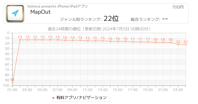
4人 [ ナビゲーション ]
|

“MapOut saves the day by using a simple interface to draw routes, and check out elevation profiles… I’m pretty blown away by its capabilities.” – Alee from cyclingabout.com
Offline map covering the whole world for iPhone and iPad. Almost as beautiful as a paper map - only more versatile.
- For hikers: With an easy-to-read representation of the terrain, even in the furthest corners without internet
- For cyclists: With cycling route network, speed and distance display
- For city travelers: City maps with tourist information
- For t...
 3人 [ 旅行 ]
|

どこにいてもコストをローミングIN円千セーブ。
更新地図、非常に高速かつ美しいです。興味のポイント数百万。
道路表示はリアルタイムでマップや映像上に表示されます。今すぐやってみて下さい!
-------------------------------------------------- ----------------------------------------
►100% オフライン- それは、いつでもどこでも動作します。
- いいえ、インターネット接続は必要ありません。
- いいえ、国際ローミング費用。
- あなたはあなたの国で使用してデータプランの長寿命。
►更新されたマップの寿命が含ま
- あなたはどのレベルでもズームすることがで...
 3人 [ ナビゲーション ]
|

Explore the rich landscapes around the Grand Canyon and Arizona while you discover Scenic Map, the best 3D topo map for the iPad and iPhone. The vector map data is contained within the app and can be used without an internet connection. Use it in a car, a boat, a plane or while hiking.
Online satellite image overlays add breathtaking detail and realism to the maps (tap preset 2 or 4 when Online Map is enabled). You can use them as you travel to see what is hidden from view at ground level. This takes moving maps to a whole new lev...
|
2人 [ ナビゲーション ]
|

OzRunways - Australia's #1 Electronic Flight Bag (EFB) is now available internationally.
APPROVED BY Australian CASA under CASR 175.
(See https://support.ozrunways.com/kb for information).
Download now for a 1 month free trial.
Download aeronautical publications onto your iPhone & iPad. See your position on every aviation map.
Properly licensed documents ensure you will stay up-to-date with the latest amendments of:
- Australian MAPS (Every updated VTC, VNC, WAC, ERC High/Low & PCA), ERSA, DAPS and AIP.
- New Zealand ERC, VNC,...
|
2人 [ ナビゲーション ]
|

Introducing Mapply, the ultimate map viewer for Open Street Map (OSM) and tile-based map layers. With Mapply, you're one tap away from exploring the world in detail, navigating transport networks, embarking on outdoor adventures, and discovering intricate topography - all tailored to your needs. Experience satellite views, hiking trails, topography, railway routes, seas, terrain analysis, and much more!
Uncover the World of Open Street Map (OSM): With OpenStreetMap, a , of the world, rich in details about locations both near and d...
Now Loading...

「iPhone & iPad アプリランキング」は、最新かつ詳細なアプリ情報をご紹介しているサイトです。
お探しのアプリに出会えるように様々な切り口でページをご用意しております。
「メニュー」よりぜひアプリ探しにお役立て下さい。
Presents by $$308413110 スマホからのアクセスにはQRコードをご活用ください。 →
Now loading...