フリーワード アプリケーション検索
6451件が見つかりました。646ページ中2ページ目を表示しています。
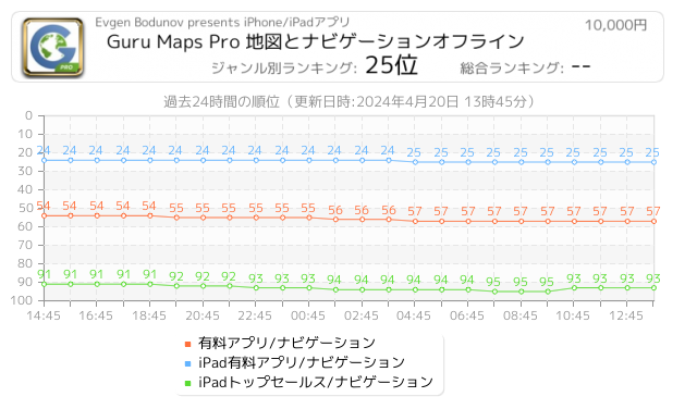
 107人 [ ナビゲーション ]
|

オフラインでもどこでも好きな所に — オフラインベクターマップとオフライン検索が、より快適な旅を実現します。GPSトラック機能を使用した軌跡の記録や、お気に入りスポットのブックマーク、デバイス間での同期も可能です。
オフラインマップ:
・無制限 — 複数の国や地域を無制限にダウンロード可能。
・詳細かつ充実した情報 — データはOpenStreetMap.orgを元にして作成。
・最新かつ正確 ― 月毎のアップデートを実行。
・他アプリと比べて省スペースで迅速な動作 — ベクターマップの表示にはCPUに加えてGPUを使用。
・ラベルサイズ変更可能 ― ラベルをマップ上に拡大すれば...
 85人 [ ナビゲーション ]
|

単独モード、ネットワークモードの両方で動作するプログレード新世代GPSシステム。
[スマホ用GPSアプリとして、2009年からの信頼実績。iPhone, iPad両用。アプリ使用にはサブスクリプションが必要です。]
1) 単独モード(スマホのみ)
このモードでは、プログレードの伝統的なGPSアプリとして動作。
• フル装備の高性能をシンプルで使い易いユーザーインターフェイスで。
• 数日間の連続計測に耐える信頼性。
• 地球一周といった長大なトラックを扱うスケーラビリティー。
• スマホに過去の数年分の全トラックを格納可能。実質上、ディスク容量をセーブするために、トラッ...
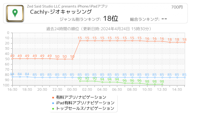
 78人 [ ナビゲーション ]
|

Cachlyは、ジオキャッシングのシンプルかつパワフルなiOSアプリです。進歩的な機能を沢山持っており、例えば以下のような機能があります。
- ジオキャッシング・アカウント
CachlyはGeocaching Live APIを利用しているので、あなたのアカウントでログインできて、すべてのアカウント情報を見ることができます。
-アドベンチャーラボ
通常のキャッシュと一緒にAdventureLabのキャッシュをロードし、オフラインで保存することもできます。
- キャッシュの捜索
現在地と座標の表示ができるほか、ある地点やGCコードの検索ができます。
- ログの投票
役立つログに投票
- 孤独な...
 39人 [ 旅行 ]
|

Travelling to London, Paris, New York, or Tokyo? Ulmon’s free travel guides cover the world’s most exciting cities. Download your comprehensive travel companion with in-depth curated content from travel experts, tips, photos, and more. Make the best out of your trip and join millions of travelers worldwide who trust Ulmon travel guides!
Travelling without internet access? No problem! Ulmon Guides work also when you are offline You can download your travel guides including offline city maps to your device for free.
And here’s w...
 36人 [ ナビゲーション ]
|

Speed Limit App displays the current speed limit and your current speed. It detects European speed limit signs using the camera while driving and enhances the results by map based limits from OpenStreetMap. Thus it will even know limits which are not indicated by signs (i.e. Zone 30, or inner city areas). Of course it will warn you when you are too fast.
► Working principle of Speed Limit App
Speed Limit App is a road sign recognition app. For inner city limits we use map based information from OpenStreetMap. Both information is ...
 34人 [ ユーティリティ ]
|

Go Map!! lets you create and edit information in OpenStreetMap, the free crowd-sourced map of your neighborhood and the world. Add shops and restaurants, streets, cycling and hiking paths, buildings, lakes and rivers.
• Quickly add points of interest
• Edit nodes, ways and areas
• Track your location and heading
• Create and resolve Notes
• Supports arbitrary tag values
• Full undo/redo support
• Work offline and upload your changes later
• Bing, Mapbox and Mapnik backgrounds, or customize with your own
• See who last edited an ob...
 15人 [ ナビゲーション ]
|

VoxTrek provides world wide turn by turn GPS navigation with text to speech directions and speed camera detection.
In this new version you can download OpenstreetMap data from cities to enable offline route calculation and offline street and point of interest search.
VoxTrek is ideal to find your way in cities around the world as no internet connection is required and will save you roaming charges.
Please read the manual and watch the tutorial videos at http://www.voxtrek.com/user-manual for a quick overview of the user interfac...
|
14人 [ ナビゲーション ]
|

[GPS遠隔リアルタイムトラッキングサービス、GPS-Trk Net リリース!(https://gpstrk.hc-eng.comをご覧下さい。http://hc-eng.com/gpstrknetにデモビデオもあります。)]
アプリ単独、遠隔リアルタイム両用プログレードGPSアプリ
アウトドア(自転車、ランニング、登山、飛行、船)
ビジネス(車両管理)
トラックを記録、地図表示、インポート/エクスポート
先進技術を、クイック動作、使いやすいユーザーインターフェースで
4年間の高信頼、安全運行実績
[iPad 2|3|4|Mini|Mini Retina|Air + iOS8, 9用
トラック/オフライン地図ビュアーはiPad Wi-Fiで動作。GPS計測はiPad...
 13人 [ ナビゲーション ]
|

Find the best route to your destination even without an internet connection. Magic Earth uses OpenStreetMap data and a powerful search engine to offer you the optimal routes for driving, biking, hiking, and public transportation.
PRIVACY FIRST!
• We do not track you. We do not profile you. We do not trade in your personal data; moreover, we do not have it.
MAPS
• Save big on mobile internet costs and navigate reliably with offline maps powered by OpenStreetMap. 233 countries and regions are ready to be downloaded.
• Choose betw...
 12人 [ ヘルスケア/フィットネス ]
|

◆ MAIN FEATURES ◆
• GLOBAL MAPS FOR OFFLINE USE
Download maps of the world for free to stay on track and be confident wherever you go.
• VIEW ANY ROUTE ON 3D MAP AND 3D FLYOVER
Visualize where you’re heading and get a more intuitive understanding of terrain and elevation for any trail or activity.
• PLAY 3D FLYOVERS TO RELIVE YOUR ADVENTURES
Relive the best moments of your journey, complete with your photos, anytime you want.
• CUSTOMIZE YOUR ROUTE
Plan your route easy and fast, and be better prepared before you set out.
• SAF...
Now Loading...

「iPhone & iPad アプリランキング」は、最新かつ詳細なアプリ情報をご紹介しているサイトです。
お探しのアプリに出会えるように様々な切り口でページをご用意しております。
「メニュー」よりぜひアプリ探しにお役立て下さい。
Presents by $$308413110 スマホからのアクセスにはQRコードをご活用ください。 →
Now loading...