MapOut |


|
価格 | 700円 | ダウンロード |
|
|---|---|---|---|---|
| ジャンル | ナビゲーション | |||
サイズ | 73.0MB | |||
| 開発者 | Valnova | |||
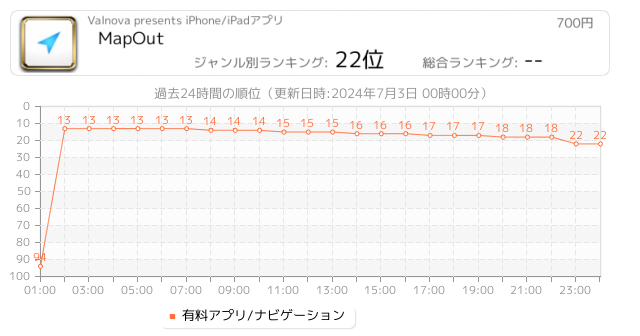
| 順位 |
| |||
| リリース日 | 2012-03-20 11:22:13 | 評価 |
|
|
| 互換性 | iOS 8.0以降が必要です。 iPhone、iPad および iPod touch 対応。 | |||
|
||||
 (4人)
(4人)
“MapOut saves the day by using a simple interface to draw routes, and check out elevation profiles… I’m pretty blown away by its capabilities.” – Alee from cyclingabout.com
Offline map covering the whole world for iPhone and iPad. Almost as beautiful as a paper map - only more versatile.
- For hikers: With an easy-to-read representation of the terrain, even in the furthest corners without internet
- For cyclists: With cycling route network, speed and distance display
- For city travelers: City maps with tourist information
- For the connoisseur: Simply beautiful map to look at
3D tilt view
- Tilt the device in any direction to get a better impression of the terrain. More information on https://mapout.app.
Search feature
- Search for places, streets, mountains, etc. No internet connection required.
Map material
- MapOut is based on the OpenStreetMap project, the “Wikipedia of Maps” - you can make corrections and additions yourself on OpenStreetMap.org. The latest maps are delivered with periodic updates.
- Download the regions of your choice - the maps can now be displayed without an internet connection (offline map).
Tours
- Drawing: Draw your own routes and waypoints directly on the map. Retouch existing tours and imported GPX files or let them directly snap to the road network.
- Import: With a free “MapOut.me” account you can send directions by email to your device. GPS-Tours can be found as gpx or kml files on many websites with tips for hiking or biking (e.g. on www.gpsies.com)
Record: Take recordings of your own tours and share them with friends.
Information: Quick overview of each tour - length, altitude change, map section and route profile
Map view
- Fast map display (hardware accelerated)
- Step-free zoom, always a pixel-perfect map
- Topographical map with contour lines and shading
- Selectable overlays: Bike/hike/ski routes, sightseeing, public transport
Find all answers to your questions in our user manual: https://mapout.app/manual
Map data © OpenStreetMap contributors (https://www.openstreetmap.org/copyright)
更新履歴
- various bug fixes
ブログパーツ第二弾を公開しました!ホームページでアプリの順位・価格・周辺ランキングをご紹介頂けます。
ブログパーツ第2弾!
アプリの周辺ランキングを表示するブログパーツです。価格・順位共に自動で最新情報に更新されるのでアプリの状態チェックにも最適です。
ランキング圏外の場合でも周辺ランキングの代わりに説明文を表示にするので安心です。
サンプルが気に入りましたら、下に表示されたHTMLタグをそのままページに貼り付けることでご利用頂けます。ただし、一般公開されているページでご使用頂かないと表示されませんのでご注意ください。
幅200px版
幅320px版
お気に入りのアプリをご紹介頂くためのブログパーツです。アプリの価格や順位表示は毎日自動更新♪
サンプルが気に入りましたら、下に表示されたHTMLタグをそのままページに貼り付けることでご利用頂けます。
※配信を停止させていただく可能性もございますので、タグの改変はご遠慮ください。

Now Loading...

「iPhone & iPad アプリランキング」は、最新かつ詳細なアプリ情報をご紹介しているサイトです。
お探しのアプリに出会えるように様々な切り口でページをご用意しております。
「メニュー」よりぜひアプリ探しにお役立て下さい。
Presents by $$308413110 スマホからのアクセスにはQRコードをご活用ください。 →
Now loading...