フリーワード アプリケーション検索
100件が見つかりました。10ページ中5ページ目を表示しています。
|
[ ユーティリティ ]
|

As a pilot you face with a lot of abbreviations, acronyms and codes each day. Sometimes it is hard to remember all of them. By using this application you can search abbreviations & acronyms used in aviation. You can add abbreviations to your favorite list.
Application includes 17828 abbreviations!.
*6205 abbreviation
*6510 airport code icao iata code
*3648 abbreviation used in notam
*1465 abbreviation used in weather reports.
-You can search airport codes by ICAO or IATA code.
-You can search terms published in notam.
-You c...
|
[ ナビゲーション ]
|

Obtain NOTAM reports for specified airfield ICAO codes
Features include:
* Global coverage (using data from US FAA, no affiliation)
* ICAO Lookup (via airfield name, country, ICAO partial code)
* Share NOTAM reports via email, Twitter, etc
* Remembers your last specified ICAO codes for quick refresh of NOTAM reports
|
[ ナビゲーション ]
|

Long Haul Pilot - The Professional Pilot App for Pilots. This app works offline for in flight use. It allows you to create colour coded airport lists. Then sync NOTAM, WX and Notes about these airports to assist in decision making in an Emergency.
This app is designed to help a Long Haul Pilot keep situational awareness of off route airports, using custom lists of company Alternates. Offline Weather (with Decode TAF, TTF Data, NOTAMS, Runway Orientation Maps, Navigation Aids, and Company Ranking for the use of these airports, Worl...
|
[ ナビゲーション ]
|

notamLocalizer will aim to display NOTAMs (Notices to Airmen) on a map at their exact location -and unlike other products- with their exact shape whenever possible. Also your ATC flight plan route can be entered and will be shown.
This effectively reduces dozens of pages containing airport and FIR Notams to a graphical representation that lets you immediately determine if your flight path is close to any area announced in a NOTAM.
It is possible to toggle off special symbols such as enroute alternate airports or NOTAMs referring ...
|
[ ナビゲーション ]
|

Whether you are a recreational drone pilot or a fully-fledged professional drone pilot, ok2fly™ is the drone safety tool you need for you next drone mission. ok2fly boasts the following functions:
1. Detailed visualization of runway splays and airport envelopes
- Splays and envelopes are clearly displayed so the pilot can identify boundaries between airspace inside and outside of the operational areas.
2. Extended radius review of the drone flight area
- ok2fly will survey not only the location you will be flying from, but the im...
|
[ ナビゲーション ]
|

E' la prima app interamente italiana che aiuta il pilota SAPR o il semplice appassionato di droni a capire dove può volare e che tipo di autorizzazioni sono necessarie per farlo.
L'app è dotata di una mappa in continuo aggiornamento che mostra una serie di layer informativi, dalle classiche CTR, ai corridoi di decollo ed atterraggio, alle NO FLY ZONE ed i NOTAM in tempo reale.
Fornisce funzionalità per la richiesta di nulla osta automatici su molte zone, oltre alla possibilità di richiedere nulla osta in app ad aziende partner.
...
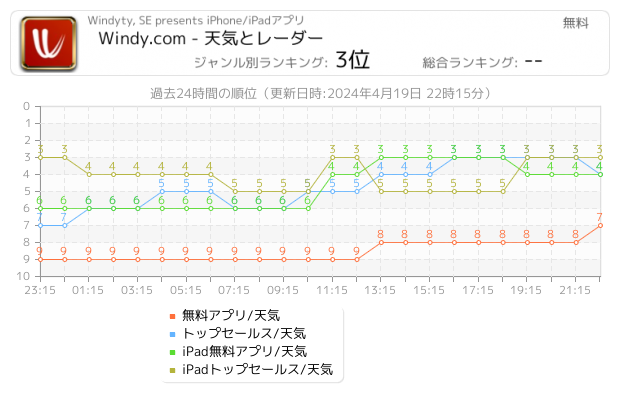
 48942人 [ 天気 ]
|

独自の見やすい天気予報
ほとんどの天気予報アプリでは、無料のグローバルモデルのみを使用していますが、Windy ではさらに、正確な天気予報を確実に行うために、利用可能な中でもっとも正確で、常に可能な限り分解能の高いモデルにも多額の投資をしています。
利用可能な気象モデル:ECMWF(分解能 9 km)、HRRR、NAM、GFS、ICON-D2、ICON-EU、ACCESS、AROME、NEMS
気象レーダーと衛星画像
気象レーダーは、天気予報でもっとも必要なツールです。利用者が予想外の雨、雪、嵐などに遭うことのないように、可能な限り正確なレーダー画像を提供するため、弊社では絶えずリソー...
 73人 [ ナビゲーション ]
|

Looking for the most comprehensive software solution for flight simulation? Navigraph Charts is your co-pilot.
Navigraph Charts 8 has been developed with emphasis on delivering a seamless and intuitive experience, reducing the pilot workload in all phases of the simulated flight.
Why you'll always want Navigraph Charts with you in the cockpit:
- Only provider of Jeppesen charts and navigation data for flight simulation.
- Access to IFR chart coverage at over 7,000 airports worldwide.
- Charts and data sourced from Jeppesen and...
 38人 [ ナビゲーション ]
|

Airmate is a free and easy to use Electronic Flight Bag for pilots, providing help for flight planning and navigation, improving situational awareness and providing social sharing features.
Thanks to Airmate EFB flight planning tools, you will get instant access to airport data and aviation maps worldwide, up to date weather and NOTAMs, traffic around, and you could even file a flight plan.
IFR and VFR airport diagrams and plates are freely available in US (FAA charts), all Europe, and more than 200 other countries. Most of them ...
 7人 [ ナビゲーション ]
|

More than 25,000 aeronautical charts of United States aerodromes.
AeroChartUS is an application designed for pilots and aviation enthusiasts. It is a pioneer in the segment. AeroChartUS is an aggregator and content organizer, focused on commercial aviation, which aids in navigation and allows the visualization of navigation charts.
This app facilitates access of pilots to charts - formerly accomplished via PDF through generic readers . Adapted for mobile device access just getting more practical and organized.
TERMINAL PROCEDU...
Now Loading...

「iPhone & iPad アプリランキング」は、最新かつ詳細なアプリ情報をご紹介しているサイトです。
お探しのアプリに出会えるように様々な切り口でページをご用意しております。
「メニュー」よりぜひアプリ探しにお役立て下さい。
Presents by $$308413110 スマホからのアクセスにはQRコードをご活用ください。 →
Now loading...