フリーワード アプリケーション検索
100件が見つかりました。10ページ中1ページ目を表示しています。
 1人 [ ユーティリティ ]
|

NOTAM Decoder is a convenient reference guide for pilots, providing quick access to "Notice to Airmen" aviation and weather contractions including the standard aviation weather products, such as METAR/TAF, area forecasts, SIGMETs, AIRMETs, etc. Note: This app contains only those contractions that are found in "Notice to Airmen".
Simply enter the contraction you wish to decode into the text box. Upon submission you will be presented with a description, or list of descriptions, that match, or decode, that contraction as found in ...
|
[ ユーティリティ ]
|

The NOTAM application gives a graphical representation of the FIR Notams on a Map.
Using the built in GPS features of the iPad or iPhone will allow a 'moving' map (based on Google Maps) for better positional awareness.
Clicking on an icon will display the specific Notam Text.
Notams that refer to AIP restricted or prohibited area's will always be shown as a circle instead of the actual area! All other areas that contain geographic GPS coordinates in the actual Notam will be displayed as a magenta colored area on the map.
The appl...
|
[ ナビゲーション ]
|

Notam sur Aérodromes - Route Standard - Route Etroite - FIR Régions d’Information de Vol en Français
NOTAM-AERO est la seule application en Français regroupant l'ensemble des NOTAM d'aérodromes et en route ainsi que des SupAIP, AZBA et AIC en France
=====Liste des fonctionnalités disponibles:
NOTAM:
- Sur Aérodromes, sur Route Standard (aérodromes et FIR) ou Etroite ou FIR Régions d’Information de Vol
- Tous les terrains en France et les principaux d'Europe
ZONE MILITAIRE BASSE ALTITUDE
- Affichez toutes Cartes AZBA pour conn...
|
[ 仕事効率化 ]
|

Global Coverage with Federal NOTAM Service (FNS) Interface
Fetches all types of NOTAMs including International, Domestic and Military notices directly from FAA (We have integration with FAA and do not crawl or scrape notices from FAA or other websites).
The traditional way, NOTAMs are distributed is old fashioned and does not serve the real purpose. The main objective of NOTAM app is to improve access to NOTAMs by making them handy and always accessible offline. This app also makes NOTAMs more readable and provides tool to decode...
 185人 [ ナビゲーション ]
|

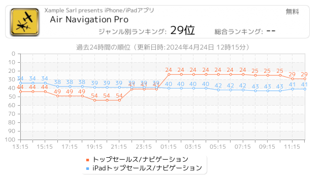
Discover our flight planning & real-time navigation app for free for 28 days!
- Everything you need to fly around the world
- Plan your flight in a few minutes
- Fly relaxed with up-to-date information
Air Navigation Pro is a high-quality flight assistant app for pilots worldwide. Benefit from the following main features:
MOVING MAP
Plan and navigate using our interactive moving map. Choose between aeronautical charts, satellite or our vector map as a background. On top of that, the moving map displays waypoints, NOTAM, obstacles...
 45人 [ 天気 ]
|

Get real-time airport weather data (Aviation WX/METAR/TAF/NOTAM) directly to your iPhone and iPad. Search for weather stations and airports all over the World (FAA, EASA,...). Easy Aviation Weather - WX is a quick and simple solution to make your flights as safe as possible.
This application is designed to provide aviation weather information for pilots including the followings:
- Current weather - METAR data
- Terminal Aerodrome Forecasts - TAF data for aviation weather forecast
- Automatic wind calculations - For each runways...
 20人 [ 辞書/辞典/その他 ]
|

The airport directory for your flight bag, with NOTAM, SNOWTAM, METAR and TAF reports, Favorites, Tools, and the ability to save your own notes for those airports you visit frequently.
FEATURES:
- Optimized for both the iPad and the iPhone. Buy once and use on all your iOS devices!
- Airport database containing over 27000 airports world wide.
- Quick search system lets you find airports by city, name, ICAO, IATA or Local identifier.
- Add your own notes for those airports you visit frequently. Attach photos, PDF documents and...
 8人 [ ナビゲーション ]
|

Easy and fast NOTAM briefing for pilots of general aviation directly on the smartphone or tablet.
After entering the route, the relevant NOTAMs (notice to airmen) are displayed both as a list and on the map.
VFR and IFR NOTAMs are shown.
No guarantee of correctness. Please report errors to mail@flugbetrieb.com
 4人 [ 天気 ]
|

リアルタイムの空港気象データ (Aviation WX/METAR/TAF/NOTAM) を iPhone、iPad、Watch に直接送信します。世界中の気象観測所、空港、ヘリポート、水上飛行機基地、気球港 (50,000 以上) を検索します (FAA、EASA など)。WX Aviation Weather は、フライトを可能な限り安全にするための迅速でシンプルなソリューションです。すべての気象データはキャッシュされ、オフラインでアクセスできます。
アプリには空港データベースが組み込まれており、滑走路、日の出/日の入り、周波数、磁気偏差などの空港データが含まれています。
このアプリケーションは、パイロットに次の航空...
 3人 [ ナビゲーション ]
|

SkyDemon is Europe's favourite software for VFR flight planning and in-flight navigation.
Use this app to access your SkyDemon subscription on your iOS device, unlocking SkyDemon's powerful features while on the move.
FLIGHT PLANNING FEATURES
- SkyDemon vector charts are the clearest aeronautical charts you'll ever use, with dynamic airspace clipping and choice of map layers
- Route planning is as simple as touching consecutive waypoints and dragging to make changes
- Virtual Radar shows how your route relates to airspace, terra...
Now Loading...

「iPhone & iPad アプリランキング」は、最新かつ詳細なアプリ情報をご紹介しているサイトです。
お探しのアプリに出会えるように様々な切り口でページをご用意しております。
「メニュー」よりぜひアプリ探しにお役立て下さい。
Presents by $$308413110 スマホからのアクセスにはQRコードをご活用ください。 →
Now loading...