フリーワード アプリケーション検索
127件が見つかりました。13ページ中4ページ目を表示しています。
|
[ ビジネス ]
|

The SurveyVideo is Move4U's latest solution!
It is a live video call that allows the customer and surveyor to connect and professionally estimate the clients inventory.
Move4U has created SurveyVideo an app that allows companies to create an inventory list from all over the world, to make removals easy both for the company and especially for costumers with a busy agenda. With this app, both parties can set up an appointment, without actually meeting up. SurveyVideo was designed to connect costumers with a virtual surveyor through ...
|
[ ライフスタイル ]
|

Garden Surveyor Touch is a Garden layout tool and Information system to manage you garden. It allow the user to place plants on a floor plan of their planting area and provides the expected spread of each planting. It provides detailed information on each planting and allows the user to expand this information with their own notes. I has multiple pictures of many of the most popular plants and allows the user to add their own custom plants. The system also provide recommendation by a local gardener for the provided plants. Dep...
|
[ ビジネス ]
|

This app facilitates auditable traffic data collection for professional traffic engineers and planners.
Surveys:
- Intersection turning movement counts
- Trip Generation (with or without vehicle occupancy)
- Parking Generation
- Vehicle Classification
- Pedestrian and bicycle counts
- Parking Occupancy
Features include:
1) Simple and Intuitive Set-Up
•No site setup inputs required.
•Flexible User define data class recordings (up to 40 different recording inputs).
•Flexible multiple surveyor projects. (1-4 Surveyors)
•Surveyor co...
|
[ ライフスタイル ]
|

Sprinkler Surveyor is the touch version of the popular layout tool Sprinkler Surveyor. It is designed to help the professional or do it your self-er plan out the layout of their sprinklers. Sprinkler parameters (throw, angle) and property layout parameters (boundary points) are entered in an interactive editable drawing using common touch gestures. Help is also provided. It will work in either feet or inches. From here, one can easily design the sprinkler layout and and examine the resulting coverage of the combined patterns. ...
|
[ ビジネス ]
|

Resolution Inspections is an extension of the ‘Dataspace Live’ inspection module.
Download inspections assigned to a surveyor from ‘Dataspace Live’, along with all required data, documents, notes etc.
It delivers the ability for ‘Dataspace Live’ users to carry out inspections on site, with or without an internet connection.
Once an inspection has been carried out, it can be finalised and uploaded to ‘Dataspace Live’ containing photos, comments and outstanding conditions which the surveyor captured via their mobile device.
|
[ ビジネス ]
|

Christopher Chai Registered Surveyor has expanded into one of the biggest registered land surveying firm in Singapore.
We are equipped with the latest gadgets, PC hardware and software. We take pride in providing quality and reliable servicse for our clients.
Our opening hours are Mon to Sat - 10am - 5pm
- View our services on the go
- Stay up to date with our firm at anytime
- Make online appointments
- Make online feedback
- View online galleries
 1637人 [ ナビゲーション ]
|

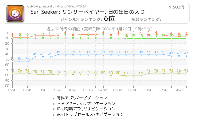
Sun Seeker is a comprehensive solar tracking & compass app. It shows the sun’s hourly direction intervals, its equinoxes, winter & summer solstice paths, sunrise & sunset times, twilight times, shadowed periods, UV Index, solar irradiance, golden and blue hours & more. The app allows you to add sun-event notifications & has a widget and watch app showing the day’s solar data & position on an arc. The 3D View shows the solar direction for each sunlight hour. Sun Seeker has both a flat compass view & a 3D Augmented Reality (AR) view ...
 67人 [ ゲーム ]
|

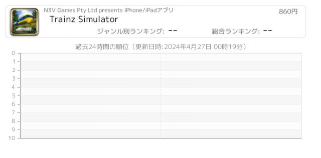
Build and operate the railroad of your dreams in an incredible 3D world. Choose either easy or realistic driving modes, and take charge of your favorite trains from around the world.
• #1 Ranked Overall iPad App in 20 countries including USA, UK and Australia
• Top 5 Ranked Simulator iPad App in over 100 Countries
With Trainz custom built input system to get the most out of the iPad’s touch functionality you’ll find driving Trains, laying tracks, creating layouts and completing scheduled tasks a breeze. Trainz Simulator is is ...
 25人 [ 写真/ビデオ ]
|

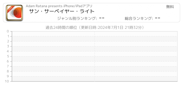
サン・サーベイヤー・ライト(Sun Surveyor Lite) は3Dコンパスを備えており、太陽、日の出と日の入の位置と時刻を予測し、可視化します!サン・サーベイヤー・ライトは、映画や写真のロケーション・スカウト、太陽電池パネルの位置設定、建築、ガーデニング、不動産、地学調査、その他多くの事に便利です!
以下へのインタラクティブ・コントロールを使用します
- "ゴールデン・アワー"の可視化と計画
- 選ばれた場所での日の出や日の入の撮影日時と角度の発見
- 一日、または年間を通しての太陽の軌道を視覚化
- 陰の比率と投影、太陽からの影を視覚化
特徴:
- 太陽のベアリ...
 8人 [ 仕事効率化 ]
|

Fields area Measure is a smart tool for measuring areas on the map. Once you place your points on the map and then calculate area between all point. you can also calculate total Area of ant Route.
Fields Area Measurement is useful to calculate GPS area or GPS distance with great accuracy. There two way to measure any GPS area or distance
FEATURES:
- Fast area/distance Mapping.
- Smart Marker Mode for super accurate pin placement.
- Measurement saving and editing
- Measurement Unit Changing Facility.
- Map, Satellite, Terrain and...
Now Loading...

「iPhone & iPad アプリランキング」は、最新かつ詳細なアプリ情報をご紹介しているサイトです。
お探しのアプリに出会えるように様々な切り口でページをご用意しております。
「メニュー」よりぜひアプリ探しにお役立て下さい。
Presents by $$308413110 スマホからのアクセスにはQRコードをご活用ください。 →
Now loading...