フリーワード アプリケーション検索
37件が見つかりました。4ページ中2ページ目を表示しています。
|
[ ナビゲーション ]
|

iBuildMapAR is a tool to create, manipulate and share geographic data.
Maps can be annotated with lines, polygons, cordons, markers and overlay images, with the app performing length and area calculations.
It is for anybody who needs to use satellite imagery, or their location, to map out areas of ground and add markers.
Features at a glance:
+ Draw straight onto a satellite image and move markers with accuracy
+ Record your location and take photographs
+ Import data and use in your plans
+ Calculate area and distance of su...
|
[ ユーティリティ ]
|

View and Convert your CSV, KMZ, GPX, GeoJson, and TopoJson to KML
What is KML?
KML stands for the keyhole markup language. KML is a file format that shows geographical data in the Earth browser such as Google Earth. KML is a tag-based structure with nested elements and a structure based on the XML standard. All tags are case-sensitive and this tag's reference depends on the KML file.
It includes lines, polygons, and images. It is used to identify label location, find a camera angle, overlay texture, and add an HTML tag.
What is...
|
[ ナビゲーション ]
|

GPS Catcher를 사용하여 위치 데이터를 아이폰/아이패드에서 효율적으로 수집하실 수 있습니다.
모바일 기기의 위치 정보 뿐만이 아니라 맵을 직접 터치하여 포인트/라인/폴리곤 데이터를 생성할 수도 있습니다.
GPS Catcher를 이용하여 원하시는 위치기반 데이터를 손쉽게 만들어 보세요.
- 주요 기능
1. GPS 트래킹
2. 터치 및 GPS 기반 포인트 데이터 생성
3. 터치 및 GPS 기반 라인 데이터 생성
4. 터치 및 GPS 기반 폴리곤 데이터 생성
5. 반경 버퍼 공간 연산
6. 버텍스 단순화 연산
7. 초단위 및 거리 단위 기록 설정
8. GPS 수신간격 설정(절전)
9. 내보내기 포맷: Sh...
|
[ 旅行 ]
|

Maptrails is a modern map browser that packs an amazing experience for hiking, hunting, orienteering, or just enjoying your time outdoors. Only Maptrails offers full featured apps for iPhone, iPad, Apple Watch and Mac.
The app comes preconfigured with a large selection of built-in maps in topographic, nautical, and aerial imagery styles. Save places as map markers that sync between your devices over iCloud. It is easy and fun to measure distances and draw paths on the map, or use Look Around to see street level imagery at any addr...
 83人 [ ナビゲーション ]
|

ZweiteGPS(ツヴァイテ ジーピーエス)はAppleマップとGoogleマップの双方に対応したGPSロガー&ビューアー、コンバーターです
本体や外付けGPSレシーバのGPS機能を利用し、現在地の表示や経路検索、行動軌跡のログ記録(バックグラウンド対応)を行います
■ ご注意
・運転中の携帯電話の使用は道路交通法違反、安全運転義務違反となりますのでご注意下さい
・内蔵マイクやジャイロ機能、バックグラウンドでGPS機能を使い続けますとバッテリーを劇的に消費しますのでご注意下さい
・本アプリケーションはGPS機能が必要です GPS機能のある端末ならびにiOS対応の外付GPSレ...
 39人 [ ナビゲーション ]
|

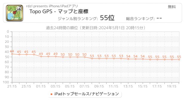
iPhone / iPadから、詳細な地形図を備えた完全なGPSデバイスを作成します。表示されたマップはデバイスに保存されるため、TopoGPSをオフラインでも使用できます。
Topo GPSをインストールできるのに、なぜ高価なGPSデバイスを購入する必要があるのですか? Topo GPSは、通常のGPSデバイスのすべての機能を低コストで提供し、はるかに詳細な地図を備えており、操作がより便利です。位置決定の精度は約5mの良好な状態です。
ウォーキング、ハイキング、サイクリング、マウンテンバイク、登山、セーリング、乗馬、ジオキャッシングトレイルランニング、その他のアウトドアアクテ...
 30人 [ ナビゲーション ]
|

The most powerful and versatile tool for viewing and editing custom maps, surveying, editing or managing mass of your geography data.
● You can use Map Plus as a professional GIS tool for geographic data gathering, editing, measuring, cartography, surveying, planning, online/offline viewing and many other management.
● You can also use Map Plus to help your outdoor activities and global travels, for trip planning, offline map downloading, track/photo/video recording, and sharing memories with friends.
Besides common map features...
 15人 [ ユーティリティ ]
|

The best tool to inspect your property or land!
Perfect for creating quotes that require estimates of property measures, pieces of land, etc.
Use it to measure, survey and explore your property, lot, backyard, etc.
Want to find out how much land you have ? How big is your lot ?
This is the tool for you - and simple and easy to use.
Now including parcel search!
Purchasing a subscription called Standard Access unlocks additional features and database updates:
a) store measurements on the cloud (up to 100 / month can be stored)
...
 12人 [ ナビゲーション ]
|

Discover the power of Pin Drop – the free app that revolutionises how you remember, organise, and plan your journeys. Seamlessly import your favourite locations from Google My Maps, What3words, Apple Maps, Mapstr, Foursquare and more to turbocharge your Pin Drop experience. Your personalised maps remain completely secure, visible only to you, unless you opt to share them with friends, family or colleagues. Pin Drop: Do it all with a map.
WHY CHOOSE PIN DROP?
- - - - - -
• Pioneer of Pin Dropping: Pin Drop is the original, the best...
 3人 [ ナビゲーション ]
|

測定は簡単です。数回タップするだけで、屋根、土地、農場、またはあらゆる不動産の面積、距離、周囲長を計算できます。測量や境界のマーキングを行う場合でも、正確な結果を即座に得ることができます。専門家にも一般ユーザーにも最適で、すべての測定ニーズを簡素化します。
# 機能:
• 5 種類の測定ツール。
• マップ上の面積、距離、半径をサポートします。
• プロジェクト内で複数のレイヤーを許可します。
• 測定には、面積に 9 種類のメートル法単位、距離に 6 種類のメートル法単位があります。
• カスタマイズ可能な線幅、線の色、塗りつぶしの色。
• 複数のマップ タ...
Now Loading...

「iPhone & iPad アプリランキング」は、最新かつ詳細なアプリ情報をご紹介しているサイトです。
お探しのアプリに出会えるように様々な切り口でページをご用意しております。
「メニュー」よりぜひアプリ探しにお役立て下さい。
Presents by $$308413110 スマホからのアクセスにはQRコードをご活用ください。 →
Now loading...