フリーワード アプリケーション検索
132件が見つかりました。14ページ中7ページ目を表示しています。
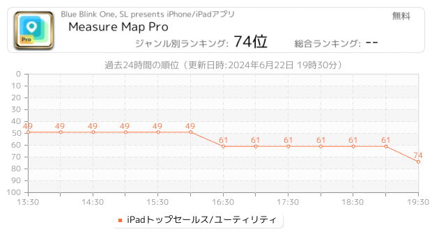
 61人 [ ユーティリティ ]
|

地図計測プロは複数の距離、境界線、そして地域を細密な正確性で簡単に計測できます。さらに地球表面の湾曲も計算に入れます。小さい地域であれ大きい地域であれ、これを利用してあなたが見つけた結果をiTunesやメールを通じてシェアしてみて下さい。"...さらに見る"をクリックしてこのappの素晴らしさを確認してみて下さい
⁕⁕⁕⁕⁕
素晴らしいアプリケーション!
うまく設計された上、理解もしやすい。私はフィールドを計測する時、ほとんどこのappを使う(アルゼンチンのパタゴニア地方)。
この特別で精密な計測ツールと衛星マップの組み合わせは、これまで想像しなかったほど私...
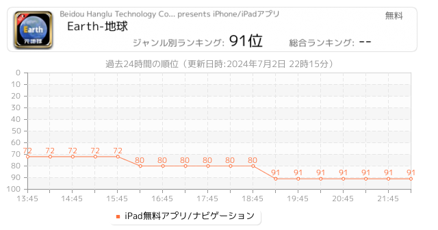
 12人 [ ナビゲーション ]
|

Earth元地球是北斗航路公司参与设计的地球卫星地图应用,用于代替谷歌地球和google地球、google earth的国内版本,可满足各行业对地理3D查看地形的需求。
卫星图层和路网导航图:
速度比谷歌地图、google地图、天地图、百度API、百度街景、高德POI、Arcgis、传统奥维互动地图更快;
经纬度:
可输入经纬度快速定位至街景地面无需使用ourplay或者谷歌空间;
夜间模式:
夜间模式可观察地球的夜景;
卫星导航:
通过指南针可矫正定位的卫星导航找到家乡家里的屋顶;
海量数据:
全球历史影像数据单一年份的高清地图数据为70TB,大数据支持谷歌空间;
轨迹:
定位时将体验飞行...
 8人 [ 写真/ビデオ ]
|

Mapillary is the street-level imagery platform that scales and automates mapping using collaboration, cameras, and computer vision.
Anyone can capture images of any place, as often as needed, with any camera—including smartphones. Mapillary combines all images into a collaborative street-level view of the world that’s available for anyone to explore and use for improving maps, cities, and mobility. Computer vision technology provides a smooth viewing experience and speeds up mapping through machine-extracted map data.
Capturing w...
 8人 [ ユーティリティ ]
|

#Socodeそれは何ですか?
Socodeは、iPhone、iPadデバイス用に設計されたソースコードリーダーで、いつでもどこでもモバイルデバイスでソースコードを表示できます。
# 特徴
- 構文の強調表示:ネイティブカラーのソースコードファイルを表示します。
- 185のプログラミング言語をサポート。
- から選択する88以上のテーマ。
- 他のアプリからのインポート/エクスポート。
- AirDropからのインポート。
- iTunesからインポートします。
- ブラウザからアップロードする。
- GitHubからインポートリポジトリ。
- ドキュメントアウトライン(クラス、関数...)
...
 5人 [ ユーティリティ ]
|

農業地図計測プロは複数の距離、境界線、そして地域を細密な正確性で簡単に計測できます。さらに地球表面の湾曲も計算に入れます。小さい地域であれ大きい地域であれ、これを利用してあなたが見つけた結果をiTunesやメールを通じてシェアしてみて下さい。"...さらに見る"をクリックしてこのappの素晴らしさを確認してみて下さい
外柵工事、スポーツツアー、旅行など、あらゆる用途で、エリア、ビル、敷地、階段??、森の表面などを、現地で直接計測せずに計算することができます。指1本でGoogle Mapを通じた驚くべきの正確さの計測が可能です
プロの正確さを犠牲にすることなく...
 3人 [ ナビゲーション ]
|

See your GPS position on your own maps. Draw points, polygons and lines on the maps. Collect field data and notes related to a location, attach a photo and fill custom properties.
Display offline maps generated with MapTiler (https://www.maptiler.com).
Choose from various basemaps like street and satellite. Preview on a mobile device the map you previously designed with own colors and fonts in MapTiler Cloud.
The app supports GeoJSON and MBTiles formats and data synchronization between multiple devices and desktop computer usin...
 1人 [ ナビゲーション ]
|

MAPS n TRAX is a VERSATILE and HIGHLY CUSTOMIZABLE offline map viewer, GPS track recording and WAYPOINT detail recorder.
* IMPORT AND VIEW YOUR OWN MAPS and GPS tracks on your device, and record tracks and detailed WAYPOINT notes. MAPS n TRAX excels in rugged "off the grid" professional, academic, and recreational activity on land, sea or air!
* GREAT SUPPORT! MAPS n TRAX is well-supported with a detailed online User Guide (http://rallyto.com/maps-n-trax/maps-n-trax-user-guide/) and responsive, personal email support.
With MA...
|
[ ビジネス ]
|

The ultimate platform digital mapping
o is a powerful digital field management mapping application developed to perform fast geologic surveys and GIS data collection.
o works on IOS IPAD's and could be integrated with GIS servers like ArcGIS and QGIS.
o web platform tools allow you to easily assign the geo-feature layers to your coworkers and control the main settings through one complete platform
• Main features
- Operate online/ offline
- OGC standard support
- a map view for navigation with support for raster and vect...
|
[ ユーティリティ ]
|

LAUSD Service Calls is a free and easy to use mobile service that allows anyone within the LAUSD boundaries to report maintenance service calls using their mobile phone. Principals, Teachers, Students, Parents, and the public as a whole will be able to easily report issues to maintenance services (Graffiti, Vandalism, Repairs) for quick resolution.
Mapping API provided by Esri ArcGIS API for iOS.
Map Data Copyright:© 2009 ESRI, i-cubed, GeoEye.
|
[ ユーティリティ ]
|

CoSSpotter is a real time mobile civic engagement tool. CoSSpotter provides a free, simple, and intuitive tool empowering citizens to identify civic issues (abandoned vehicles, graffiti, fly tipping, etc.) and report them to the Civic Centre for quick resolution; an opportunity for government to use technology to save money and improve accountability to those they govern; and a positive, collaborative platform for real action. CoSSpotter is powered by CitySourced, the leader in interactive civic engagement.
Mapping API provided b...
Now Loading...

「iPhone & iPad アプリランキング」は、最新かつ詳細なアプリ情報をご紹介しているサイトです。
お探しのアプリに出会えるように様々な切り口でページをご用意しております。
「メニュー」よりぜひアプリ探しにお役立て下さい。
Presents by $$308413110 スマホからのアクセスにはQRコードをご活用ください。 →
Now loading...