NP Maps - Yellowstone |
| この情報はストアのものより古い可能性がございます。 | ||||
|
価格 | 無料 | ダウンロード |
|
|---|---|---|---|---|
| ジャンル | 旅行 | |||
サイズ | 34.4MB | |||
| 開発者 | Delcartes LLC | |||
| 順位 |
| |||
| リリース日 | 2015-07-31 18:30:22 | 評価 | 評価が取得できませんでした。 | |
| 互換性 | iOS 14.0以降が必要です。 iPhone、iPad および iPod touch 対応。 | |||
Get maps in high resolution of National Park Service parks and US Geological Survey topography quadrangles of Montana, Idaho and Wyoming on your iPhone and iPad for GPS** and offline use!
NP Maps Yellowstone app provides official NPS maps of Yellowstone National Park, Grand Teton National Park and more for you to see your location on them realtime. Plus, being designed for offline use, NP Maps Yellowstone can download official USGS topographic maps for all of the USA and island territories.*
This app is priceless for road trips, hikes, camping, exploring, planning and much more! Because many of these wilderness regions have no data service, select and download maps now or while online for your travels so you can enjoy using this app as it was intended: no internet connection. And, this app can detect internet service and automatically install USGS topography or NPS map for your current location if not already done.
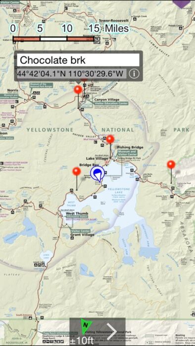
Logical and intuitive to use. Park and topography maps are geospatially integrated with Apple Maps for a familiar interface and for navigating a visual catalog of maps. A marvelous index into an extensive library covering all of ID, MT, and WY states allows you to select maps for install all with a simple touch along your planned route of travel.
Purchase a subscription period for unlimited downloading of more NPS and USGS maps. A subscription stops ads and doesn't auto-renew. The first several map download are complementary.
Features:
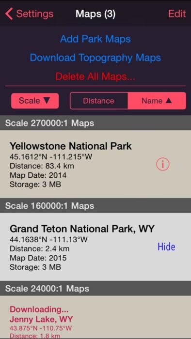
• Preloaded with Yellowstone and Grand Teton NPS maps and two 100k scale USGS topography maps covering Yellowstone.
• Access a library of 150 NPS, over 60,000+ USGS & US Forest Service maps
• Full rendering high resolution maps
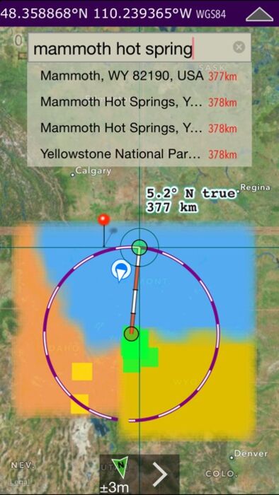
• Find geographic features worldwide with a powerful geo-code search
• Waypoints with Augmented Reality finder
• Route path creation
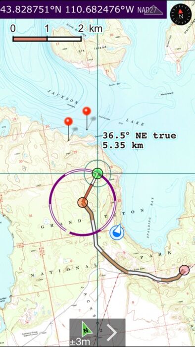
• Track/bread-crumbs GPS path recording**
• Shows your current GPS location**
• Dual mode ruler with orthographic line and path measuring
• Full app usability while maps download in the background
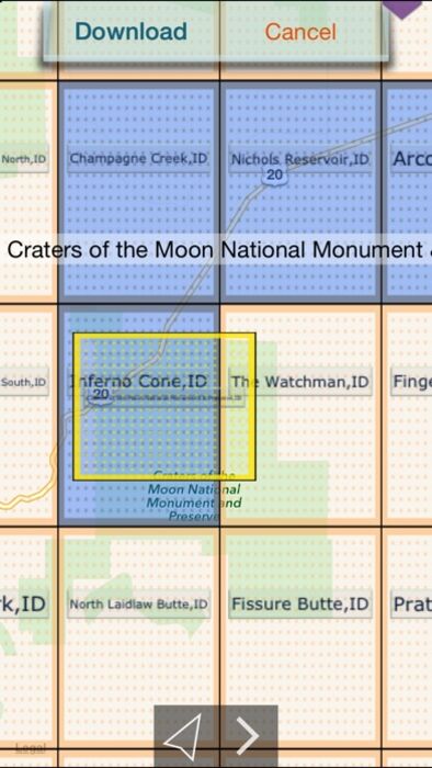
• Footprint grid index with quadrangle names for visual map selection
• Aligns differing map datums to the WGS84/GPS location
• Automatic map download for your current location
• Miles, Feet, Kilometers, Meters, Nautical Miles units
• MGRS, UTM and geodetic Latitude and Longitude coordinate formats.
• Import and export waypoints using GPX format, some support of KLM
• Detailed integrated help
• Supports rotation and follows heading map orientations
• No need for cellular service to use installed maps
• A subscription allows for more map downloads, and also stops all advertisements
• Email and SMS text waypoints, tracks and routes as GPX files, with subscription purchase
* Not preloaded with all maps. WiFi recommended for downloading map quadrangles. First several map downloads are complementary. Downloading queue does cap to around 25 maps.
** Continued use of GPS running in the background can dramatically decrease battery life.
Location and AR features won't function for iPod and iPad models without GPS hardware.
更新履歴
• iOS 16 crashing fixed.
• Nice UX and speed improvement.
NP Maps Yellowstone app provides official NPS maps of Yellowstone National Park, Grand Teton National Park and more for you to see your location on them realtime. Plus, being designed for offline use, NP Maps Yellowstone can download official USGS topographic maps for all of the USA and island territories.*
This app is priceless for road trips, hikes, camping, exploring, planning and much more! Because many of these wilderness regions have no data service, select and download maps now or while online for your travels so you can enjoy using this app as it was intended: no internet connection. And, this app can detect internet service and automatically install USGS topography or NPS map for your current location if not already done.
Logical and intuitive to use. Park and topography maps are geospatially integrated with Apple Maps for a familiar interface and for navigating a visual catalog of maps. A marvelous index into an extensive library covering all of ID, MT, and WY states allows you to select maps for install all with a simple touch along your planned route of travel.
Purchase a subscription period for unlimited downloading of more NPS and USGS maps. A subscription stops ads and doesn't auto-renew. The first several map download are complementary.
Features:
• Preloaded with Yellowstone and Grand Teton NPS maps and two 100k scale USGS topography maps covering Yellowstone.
• Access a library of 150 NPS, over 60,000+ USGS & US Forest Service maps
• Full rendering high resolution maps
• Find geographic features worldwide with a powerful geo-code search
• Waypoints with Augmented Reality finder
• Route path creation
• Track/bread-crumbs GPS path recording**
• Shows your current GPS location**
• Dual mode ruler with orthographic line and path measuring
• Full app usability while maps download in the background
• Footprint grid index with quadrangle names for visual map selection
• Aligns differing map datums to the WGS84/GPS location
• Automatic map download for your current location
• Miles, Feet, Kilometers, Meters, Nautical Miles units
• MGRS, UTM and geodetic Latitude and Longitude coordinate formats.
• Import and export waypoints using GPX format, some support of KLM
• Detailed integrated help
• Supports rotation and follows heading map orientations
• No need for cellular service to use installed maps
• A subscription allows for more map downloads, and also stops all advertisements
• Email and SMS text waypoints, tracks and routes as GPX files, with subscription purchase
* Not preloaded with all maps. WiFi recommended for downloading map quadrangles. First several map downloads are complementary. Downloading queue does cap to around 25 maps.
** Continued use of GPS running in the background can dramatically decrease battery life.
Location and AR features won't function for iPod and iPad models without GPS hardware.
更新履歴
• iOS 16 crashing fixed.
• Nice UX and speed improvement.
ブログパーツ第二弾を公開しました!ホームページでアプリの順位・価格・周辺ランキングをご紹介頂けます。
ブログパーツ第2弾!
アプリの周辺ランキングを表示するブログパーツです。価格・順位共に自動で最新情報に更新されるのでアプリの状態チェックにも最適です。
ランキング圏外の場合でも周辺ランキングの代わりに説明文を表示にするので安心です。
サンプルが気に入りましたら、下に表示されたHTMLタグをそのままページに貼り付けることでご利用頂けます。ただし、一般公開されているページでご使用頂かないと表示されませんのでご注意ください。
幅200px版
幅320px版
お気に入りのアプリをご紹介頂くためのブログパーツです。アプリの価格や順位表示は毎日自動更新♪
サンプルが気に入りましたら、下に表示されたHTMLタグをそのままページに貼り付けることでご利用頂けます。
※配信を停止させていただく可能性もございますので、タグの改変はご遠慮ください。

Now Loading...

「iPhone & iPad アプリランキング」は、最新かつ詳細なアプリ情報をご紹介しているサイトです。
お探しのアプリに出会えるように様々な切り口でページをご用意しております。
「メニュー」よりぜひアプリ探しにお役立て下さい。
Presents by $$308413110 スマホからのアクセスにはQRコードをご活用ください。 →
Now loading...