Navigraph Charts |
| この情報はストアのものより古い可能性がございます。 | ||||
|
価格 | 無料 | ダウンロード |
|
|---|---|---|---|---|
| ジャンル | ナビゲーション | |||
サイズ | 56.7MB | |||
| 開発者 | Navigraph | |||
| 順位 |
| |||
| リリース日 | 2015-06-11 10:14:25 | 評価 |
|
|
| 互換性 | iOS 14.0以降が必要です。 iPhone、iPad および iPod touch 対応。 | |||
|
||||
 (69人)
(69人)
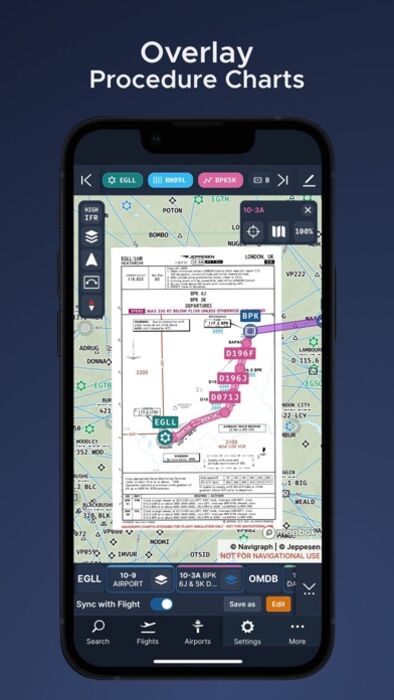
Looking for the most comprehensive software solution for flight simulation? Navigraph Charts is your co-pilot.
Navigraph Charts 8 has been developed with emphasis on delivering a seamless and intuitive experience, reducing the pilot workload in all phases of the simulated flight.
Why you'll always want Navigraph Charts with you in the cockpit:
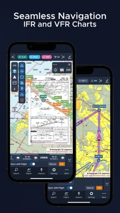
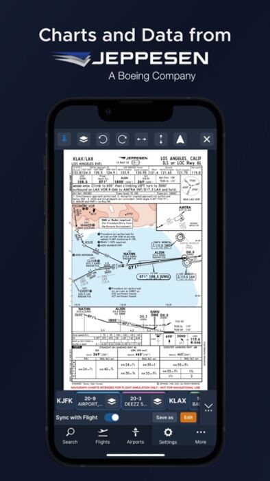
- Only provider of Jeppesen charts and navigation data for flight simulation.
- Access to IFR chart coverage at over 7,000 airports worldwide.
- Charts and data sourced from Jeppesen and updated every 28 days according to the AIRAC calendar.
- Largest dataset of its kind in the world.
- Most up-to-date and modern navigation software for flight simulation.
- Simulator sceneries, flight plans, charts, navigation systems, and addon software are all in sync with data from the same source.
- Great support.
New features in Navigraph Charts 8:
- Worldwide VFR Charts powered by Jeppesen VFR data
- Seamless Zoom
- 3D Globe Projection
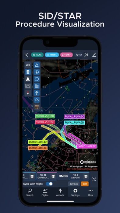
- Autopinning of Procedure Charts
- Runway Crosswind and Airport Weather Information
- Vector Charts
- Weather overlays including radar and winds
- ATIS
- NOTAM
- Annotate and draw on charts and SimBrief operational flight plan
Navigraph Unlimited features:
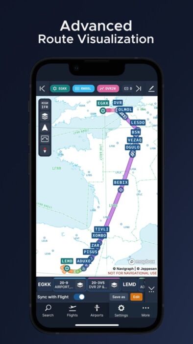
- Moving Maps
- Zoom all the way down to gate level.
- 3D globe projection helps visualize Great Circle distances and polar routes.
- Saves time and effort by automatically organizing relevant airport charts to pinboard.
- Weather information including runway crosswinds updated in real-time.
- No commitment - cancel any time you like.
Moving Maps compatible with Microsoft Flight Simulator, X-Plane and Prepar3d.
更新履歴
Features
- Added live updates to the weather feature, making it stay up to date during long periods of use
- Added visualization of currently selected runway or procedure to the selection menus
- Added persistence of last used map location and zoom across application restarts
Bug fixes & improvements
- Added airway type description to the airway information menu
- Added map zoom transition to focus on the runway when viewing runway information
- Fixed bug that would cause the flight name to reset when the origin or destination airport was changed
- Fixed bug that would result in an empty list of user waypoints until the filter function was used
- Fixed bug that caused the web application to crash if automatic translation was enabled in the browser
- Fixed bug which would cause an error when selecting a runway while at the same time manually removing the related airport from the route
- Fixed bug that resulted in errors when viewing parts of the app on certain very small screen dimensions
- Fixed bug that caused incorrect frequencies with 4 decimal places to show for enroute communications facilities with 8.33kHz spacing
- Fixed bug where the transponder code would be displayed as a single zero in the telemetry widget
- Fixed issue where runway crosswind was calculated based on the runway designator instead of its bearing, resulting in incorrect values
- Improved sorting of search results by sorting airports with equal relevancy in alphabetical order
- Improved loading indicators in several areas
- Improved the dragging feature when making annotations by changing the cursor to a "dragging" indicator while holding space
- Renamed the JustFlight export option to support future addons
- Fixed status bar color being hard to read with the device in light mode
- Center text in confirmation prompts to align with other platforms
Navigraph Charts 8 has been developed with emphasis on delivering a seamless and intuitive experience, reducing the pilot workload in all phases of the simulated flight.
Why you'll always want Navigraph Charts with you in the cockpit:
- Only provider of Jeppesen charts and navigation data for flight simulation.
- Access to IFR chart coverage at over 7,000 airports worldwide.
- Charts and data sourced from Jeppesen and updated every 28 days according to the AIRAC calendar.
- Largest dataset of its kind in the world.
- Most up-to-date and modern navigation software for flight simulation.
- Simulator sceneries, flight plans, charts, navigation systems, and addon software are all in sync with data from the same source.
- Great support.
New features in Navigraph Charts 8:
- Worldwide VFR Charts powered by Jeppesen VFR data
- Seamless Zoom
- 3D Globe Projection
- Autopinning of Procedure Charts
- Runway Crosswind and Airport Weather Information
- Vector Charts
- Weather overlays including radar and winds
- ATIS
- NOTAM
- Annotate and draw on charts and SimBrief operational flight plan
Navigraph Unlimited features:
- Moving Maps
- Zoom all the way down to gate level.
- 3D globe projection helps visualize Great Circle distances and polar routes.
- Saves time and effort by automatically organizing relevant airport charts to pinboard.
- Weather information including runway crosswinds updated in real-time.
- No commitment - cancel any time you like.
Moving Maps compatible with Microsoft Flight Simulator, X-Plane and Prepar3d.
更新履歴
Features
- Added live updates to the weather feature, making it stay up to date during long periods of use
- Added visualization of currently selected runway or procedure to the selection menus
- Added persistence of last used map location and zoom across application restarts
Bug fixes & improvements
- Added airway type description to the airway information menu
- Added map zoom transition to focus on the runway when viewing runway information
- Fixed bug that would cause the flight name to reset when the origin or destination airport was changed
- Fixed bug that would result in an empty list of user waypoints until the filter function was used
- Fixed bug that caused the web application to crash if automatic translation was enabled in the browser
- Fixed bug which would cause an error when selecting a runway while at the same time manually removing the related airport from the route
- Fixed bug that resulted in errors when viewing parts of the app on certain very small screen dimensions
- Fixed bug that caused incorrect frequencies with 4 decimal places to show for enroute communications facilities with 8.33kHz spacing
- Fixed bug where the transponder code would be displayed as a single zero in the telemetry widget
- Fixed issue where runway crosswind was calculated based on the runway designator instead of its bearing, resulting in incorrect values
- Improved sorting of search results by sorting airports with equal relevancy in alphabetical order
- Improved loading indicators in several areas
- Improved the dragging feature when making annotations by changing the cursor to a "dragging" indicator while holding space
- Renamed the JustFlight export option to support future addons
- Fixed status bar color being hard to read with the device in light mode
- Center text in confirmation prompts to align with other platforms
ブログパーツ第二弾を公開しました!ホームページでアプリの順位・価格・周辺ランキングをご紹介頂けます。
ブログパーツ第2弾!
アプリの周辺ランキングを表示するブログパーツです。価格・順位共に自動で最新情報に更新されるのでアプリの状態チェックにも最適です。
ランキング圏外の場合でも周辺ランキングの代わりに説明文を表示にするので安心です。
サンプルが気に入りましたら、下に表示されたHTMLタグをそのままページに貼り付けることでご利用頂けます。ただし、一般公開されているページでご使用頂かないと表示されませんのでご注意ください。
幅200px版
幅320px版
お気に入りのアプリをご紹介頂くためのブログパーツです。アプリの価格や順位表示は毎日自動更新♪
サンプルが気に入りましたら、下に表示されたHTMLタグをそのままページに貼り付けることでご利用頂けます。
※配信を停止させていただく可能性もございますので、タグの改変はご遠慮ください。

Now Loading...

「iPhone & iPad アプリランキング」は、最新かつ詳細なアプリ情報をご紹介しているサイトです。
お探しのアプリに出会えるように様々な切り口でページをご用意しております。
「メニュー」よりぜひアプリ探しにお役立て下さい。
Presents by $$308413110 スマホからのアクセスにはQRコードをご活用ください。 →
Now loading...