Typhoon 台風情報·嵐経路図·サイクロン衛星レーダー |


|
価格 | 無料 | ダウンロード |
|
|---|---|---|---|---|
| ジャンル | 天気 | |||
サイズ | 74.5MB | |||
| 開発者 | Elecont LLC | |||
| 順位 |
| |||
| リリース日 | 2013-09-17 07:49:36 | 評価 |
|
|
| 互換性 | iOS 11.0以降が必要です。 iPhone、iPad および iPod touch 対応。 | |||
 (31人)
(31人)
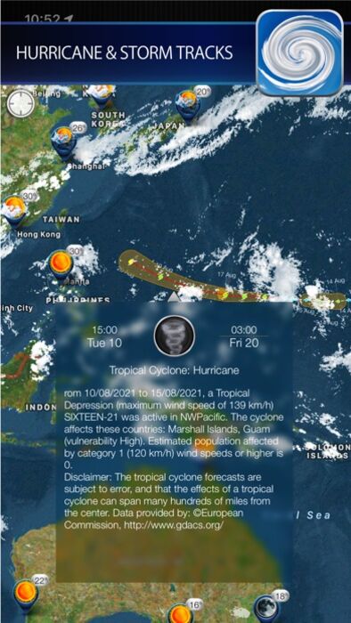
サイクロンで詳細な気象画像を確認し、嵐に備えましょう。サイクロンはオールインワンの天気アプリです。
リアルタイム衛星画像: 北アメリカ、ヨーロッパ、日本、オーストラリア、そしてロシアの一部地域の高解像度で息を呑むような雲量カバーのアニメーションをご覧ください。
信頼できるデータ: NOAA-NASA GOES、EUMETSAT、SPC、GDAC によって提供されるデータをもとに、サイクロンは世界中のあらゆる場所の正確な気象情報を提供します。
すべての嵐を追跡:
グローバル暴風追跡機能: 予測される経路と詳細な予報で、ハリケーン、台風の情報を追跡し、潜在的な脅威について最新情報を入手しましょう。
複数の気象レイヤー: 地上局データと衛星画像を選択し、現在の状況を包括的に把握しましょう。
指先で探索:
インタラクティブマップ: ズーム、パン、スクロールを行い、美しい地形マップ、衛星画像マップ、または標準マップ上で気象状況を確認しましょう。
常に予報を入手: 詳細な現在の天気情報と 10 日予報を便利なポップアップウィンドウで確認できます。
日の出と日の入りを逃さない: お気に入りの場所の日の出と日の入りの時刻を確認しましょう。
シームレスなユーザーエクスペリエンス:
スムーズなパフォーマンス: 低速ネットワークでも高速な読み込み時間とスムーズなアニメーションをお楽しみください。
カスタマイズオプション: どのズームレベルでもアニメーションの再生、一時停止、速度調整が可能です。
サイクロンは iPhone と iPad でご利用いただけます。 今すぐダウンロードして、まったく新しい視点で天気を確認しましょう!
更新履歴
Bug fixes and performance improvements
ブログパーツ第二弾を公開しました!ホームページでアプリの順位・価格・周辺ランキングをご紹介頂けます。
ブログパーツ第2弾!
アプリの周辺ランキングを表示するブログパーツです。価格・順位共に自動で最新情報に更新されるのでアプリの状態チェックにも最適です。
ランキング圏外の場合でも周辺ランキングの代わりに説明文を表示にするので安心です。
サンプルが気に入りましたら、下に表示されたHTMLタグをそのままページに貼り付けることでご利用頂けます。ただし、一般公開されているページでご使用頂かないと表示されませんのでご注意ください。
幅200px版
幅320px版
お気に入りのアプリをご紹介頂くためのブログパーツです。アプリの価格や順位表示は毎日自動更新♪
サンプルが気に入りましたら、下に表示されたHTMLタグをそのままページに貼り付けることでご利用頂けます。
※配信を停止させていただく可能性もございますので、タグの改変はご遠慮ください。

Now Loading...

「iPhone & iPad アプリランキング」は、最新かつ詳細なアプリ情報をご紹介しているサイトです。
お探しのアプリに出会えるように様々な切り口でページをご用意しております。
「メニュー」よりぜひアプリ探しにお役立て下さい。
Presents by $$308413110 スマホからのアクセスにはQRコードをご活用ください。 →
Now loading...