Swiss3D Pro |
|
価格 | 800円 | ダウンロード |
|
|---|---|---|---|---|
| ジャンル | 旅行 | |||
サイズ | 627.0MB (ダウンロードにWIFIが必要) | |||
| 開発者 | MYZ Studio | |||
| 順位 |
| |||
| リリース日 | 2012-11-24 23:07:50 | 評価 | 評価が取得できませんでした。 | |
| 互換性 | iOS 11.0以降が必要です。 iPhone、iPad および iPod touch 対応。 | |||
*** Appreciated by "Le Nouvelliste", "mac4ever.com", "iPhone-blog.ch" and perhaps you!
*** "Best of Swiss Apps Award 2017" nominated
- At which altitude and distance is the cliff over there?
- What is the name of this small town below?
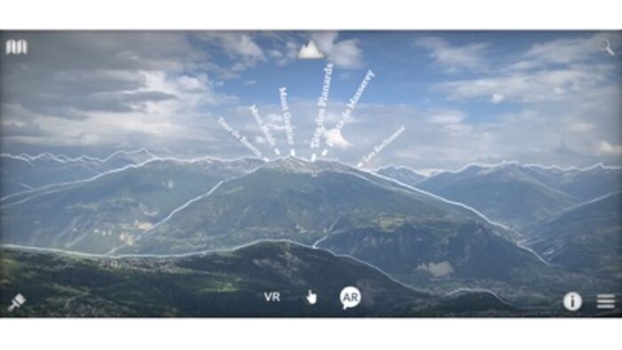
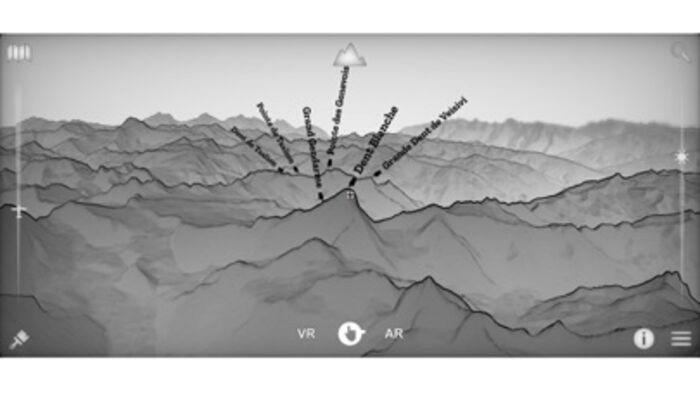
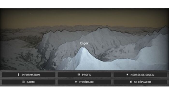
- How is called the peak we are seeing?
- What is the altitude of the Grimsel pass?
- Which mountain is the highest of the region?
- Is there a camping or a mountain refuge nearby?
- What is the name of this glacier or that lake?
- Is it Jupiter right over this peak?
- The region on this hill has a lot of sun?
- How much walk time is needed to reach that crest, is it steep?
- Is there any message posted by somebody in this area?
- I am asking myself where is the Mattherhorn from here?
- What view do we have from the top of this mountain?
- Is it full moon and where is the moon?
- Is this whole valley over 1000m?
...
It is a question list sample that can be answered with Swiss3D!
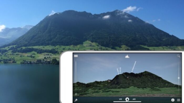
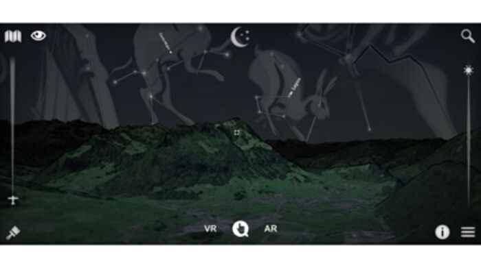
Swiss 3D is a, fully offline, precise, real time, virtual 3D map of Switzerland.
It reconstructs your surrounding landscape with accuracy and displays all peaks, towns, cities, places, lakes, passes, glaciers, mountain huts, ...
It also rebuild the current time sky and shows all brightest stars, solar system planets and all constellations.
The app contains an VR and AR mode that enable you to see the environment as seen through binoculars.
You can also share your current favorite position to everybody.
Reading a map has never been that fun and easy!
Features:
▫ no internet connection required
▫ virtual and augmented reality (ARKit) or manual mode
▫ accurate Swisstopo data
▫ 54000 places, 15000 peaks, 9000 stars, pass, lakes, mountain huts, ...
▫ landsat satellite imagery
▫ summer and winter
▫ search function
▫ dynamic aerial view
▫ easy controls
▫ map
▫ flight simulator
▫ share and comment your favorite location
▫ target information: distance, altitude, slope, sun time, walk time...
▫ only on iOS
▫ made in Switzerland for Switzerland
-> iPhone 6s (A9) and more required for the AR!
Source: Office fédéral de topographie / geonames
Satellite Image: Modified Copernicus Sentinel data [2019] swisstopo, NPOC
Elevation Data: ViewFinderPanoramas
Stars: Bright Star/Hipparcos catalogue, Jean Meeus
Constellations: Stellarium / Johan Meuris pictures
Cockpit: Vertical Reality Simulations
更新履歴
- New old school design
- Texture enhancement
- Best performance
- Bug fixes
*** "Best of Swiss Apps Award 2017" nominated
- At which altitude and distance is the cliff over there?
- What is the name of this small town below?
- How is called the peak we are seeing?
- What is the altitude of the Grimsel pass?
- Which mountain is the highest of the region?
- Is there a camping or a mountain refuge nearby?
- What is the name of this glacier or that lake?
- Is it Jupiter right over this peak?
- The region on this hill has a lot of sun?
- How much walk time is needed to reach that crest, is it steep?
- Is there any message posted by somebody in this area?
- I am asking myself where is the Mattherhorn from here?
- What view do we have from the top of this mountain?
- Is it full moon and where is the moon?
- Is this whole valley over 1000m?
...
It is a question list sample that can be answered with Swiss3D!
Swiss 3D is a, fully offline, precise, real time, virtual 3D map of Switzerland.
It reconstructs your surrounding landscape with accuracy and displays all peaks, towns, cities, places, lakes, passes, glaciers, mountain huts, ...
It also rebuild the current time sky and shows all brightest stars, solar system planets and all constellations.
The app contains an VR and AR mode that enable you to see the environment as seen through binoculars.
You can also share your current favorite position to everybody.
Reading a map has never been that fun and easy!
Features:
▫ no internet connection required
▫ virtual and augmented reality (ARKit) or manual mode
▫ accurate Swisstopo data
▫ 54000 places, 15000 peaks, 9000 stars, pass, lakes, mountain huts, ...
▫ landsat satellite imagery
▫ summer and winter
▫ search function
▫ dynamic aerial view
▫ easy controls
▫ map
▫ flight simulator
▫ share and comment your favorite location
▫ target information: distance, altitude, slope, sun time, walk time...
▫ only on iOS
▫ made in Switzerland for Switzerland
-> iPhone 6s (A9) and more required for the AR!
Source: Office fédéral de topographie / geonames
Satellite Image: Modified Copernicus Sentinel data [2019] swisstopo, NPOC
Elevation Data: ViewFinderPanoramas
Stars: Bright Star/Hipparcos catalogue, Jean Meeus
Constellations: Stellarium / Johan Meuris pictures
Cockpit: Vertical Reality Simulations
更新履歴
- New old school design
- Texture enhancement
- Best performance
- Bug fixes
ブログパーツ第二弾を公開しました!ホームページでアプリの順位・価格・周辺ランキングをご紹介頂けます。
ブログパーツ第2弾!
アプリの周辺ランキングを表示するブログパーツです。価格・順位共に自動で最新情報に更新されるのでアプリの状態チェックにも最適です。
ランキング圏外の場合でも周辺ランキングの代わりに説明文を表示にするので安心です。
サンプルが気に入りましたら、下に表示されたHTMLタグをそのままページに貼り付けることでご利用頂けます。ただし、一般公開されているページでご使用頂かないと表示されませんのでご注意ください。
幅200px版
幅320px版
お気に入りのアプリをご紹介頂くためのブログパーツです。アプリの価格や順位表示は毎日自動更新♪
サンプルが気に入りましたら、下に表示されたHTMLタグをそのままページに貼り付けることでご利用頂けます。
※配信を停止させていただく可能性もございますので、タグの改変はご遠慮ください。

Now Loading...

「iPhone & iPad アプリランキング」は、最新かつ詳細なアプリ情報をご紹介しているサイトです。
お探しのアプリに出会えるように様々な切り口でページをご用意しております。
「メニュー」よりぜひアプリ探しにお役立て下さい。
Presents by $$308413110 スマホからのアクセスにはQRコードをご活用ください。 →
Now loading...