Marine Navigation |
| この情報はストアのものより古い可能性がございます。 | ||||


|
価格 | 1200円 | ダウンロード |
|
|---|---|---|---|---|
| ジャンル | ナビゲーション | |||
サイズ | 62.5MB | |||
| 開発者 | Marco Palaferri | |||
| 順位 |
| |||
| リリース日 | 2012-05-31 07:57:49 | 評価 | 評価が取得できませんでした。 | |
| 互換性 | iOS 11.0以降が必要です。 iPhone、iPad および iPod touch 対応。 | |||
MARINE NAVIGATION
Find your way on the sea with ease! Our GPS chartplotter for boating is an easy-to-use offline GPS tracker and route planner featuring worldwide offline maps.
Whether you're a seasoned sailor, a fisherman, or just love water sports, this app is dedicated to the sea and the people who love it.
WHAT MAKES IT THE BEST GPS TRACKER AND NAVIGATOR:
Offline GPS tracker for boat navigation. GPS chartplotter for sailing and boating.
Morse Code in case of danger, Anchor Alert to prevent the drift of the anchor, and Moon Phase to show the phases of the moon during the day.
Harbors feature to see the list of ports.
Sync Waypoints feature to be able to create backups and access them from different devices.
Download the maps and marine charts, so you won't need an active internet connection for navigation and route planning.
Create a profile to save waypoints and routes, and access them from different devices.
MAPS OFFLINE:
Download maps or marine charts to navigate on preloaded maps or charts without a connection.
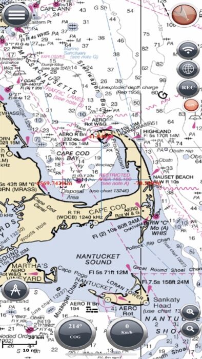
MAPS AND MARINE CHARTS:
Nautical maps of the United States of America by NOAA.
Nautical maps of the Mediterranean by NOAA.
Mediterranean RNC.
Nautical maps of New Zealand by LINZ.
Maps of the world's oceans and coastal areas by ESRI.
World topographic map includes boundaries, cities, water features, ports, physiographic features by ESRI.
Satellite imagery for the world by ESRI.
Maps for the sea, with ports, sea lights, and more by Open Sea Map.
Beta Nautical maps by Fishpoints
MAIN FEATURES:
Super easy-to-use GPS tracker tool with a clean and neat design.
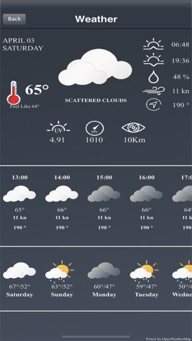
Weather feature.
GPX Import and Export.
Available in English, Italian, French, Spanish, Brazilian, Turkish, German, and Indonesian.
Download Maps to use in offline mode.
Accurate and detailed GPS Chartplotter, GPS plotter, and Marine charts.
Optimized for phones and tablets.
Receive information about speed, direction, and time to arrival.
Compass Magnetic or True.
Change Measurement Units: Km, Mi, or Nmi.
Record your route to analyze the data and renavigate your trace.
LOCATION PERMISSION
The app needs your location to trace the route on the map. Location information is processed locally on your device, ensuring your privacy.
TRY THE FREE VERSION
Get more details about the app by trying our Marine Navigation Lite version.
HELP US IMPROVE
Download Marine Navigation and let us know about any bugs, feature requests, or any other suggestions. Stay tuned for more features and options in this GPS tracker app for boating.
WARNING
Good seamanship requires the use of official charts. Marine Navigation is for use with other charts and cannot replace official charts. Use at your own risk.
LEARN MORE ABOUT FISHPOINTS
Visit our official website or join us on Facebook.
TERMS OF USE: http://www.fishpoints.net/eula/
PRIVACY POLICY: http://www.fishpoints.net/privacy-policy
更新履歴
Update Esri Maps
Find your way on the sea with ease! Our GPS chartplotter for boating is an easy-to-use offline GPS tracker and route planner featuring worldwide offline maps.
Whether you're a seasoned sailor, a fisherman, or just love water sports, this app is dedicated to the sea and the people who love it.
WHAT MAKES IT THE BEST GPS TRACKER AND NAVIGATOR:
Offline GPS tracker for boat navigation. GPS chartplotter for sailing and boating.
Morse Code in case of danger, Anchor Alert to prevent the drift of the anchor, and Moon Phase to show the phases of the moon during the day.
Harbors feature to see the list of ports.
Sync Waypoints feature to be able to create backups and access them from different devices.
Download the maps and marine charts, so you won't need an active internet connection for navigation and route planning.
Create a profile to save waypoints and routes, and access them from different devices.
MAPS OFFLINE:
Download maps or marine charts to navigate on preloaded maps or charts without a connection.
MAPS AND MARINE CHARTS:
Nautical maps of the United States of America by NOAA.
Nautical maps of the Mediterranean by NOAA.
Mediterranean RNC.
Nautical maps of New Zealand by LINZ.
Maps of the world's oceans and coastal areas by ESRI.
World topographic map includes boundaries, cities, water features, ports, physiographic features by ESRI.
Satellite imagery for the world by ESRI.
Maps for the sea, with ports, sea lights, and more by Open Sea Map.
Beta Nautical maps by Fishpoints
MAIN FEATURES:
Super easy-to-use GPS tracker tool with a clean and neat design.
Weather feature.
GPX Import and Export.
Available in English, Italian, French, Spanish, Brazilian, Turkish, German, and Indonesian.
Download Maps to use in offline mode.
Accurate and detailed GPS Chartplotter, GPS plotter, and Marine charts.
Optimized for phones and tablets.
Receive information about speed, direction, and time to arrival.
Compass Magnetic or True.
Change Measurement Units: Km, Mi, or Nmi.
Record your route to analyze the data and renavigate your trace.
LOCATION PERMISSION
The app needs your location to trace the route on the map. Location information is processed locally on your device, ensuring your privacy.
TRY THE FREE VERSION
Get more details about the app by trying our Marine Navigation Lite version.
HELP US IMPROVE
Download Marine Navigation and let us know about any bugs, feature requests, or any other suggestions. Stay tuned for more features and options in this GPS tracker app for boating.
WARNING
Good seamanship requires the use of official charts. Marine Navigation is for use with other charts and cannot replace official charts. Use at your own risk.
LEARN MORE ABOUT FISHPOINTS
Visit our official website or join us on Facebook.
TERMS OF USE: http://www.fishpoints.net/eula/
PRIVACY POLICY: http://www.fishpoints.net/privacy-policy
更新履歴
Update Esri Maps
ブログパーツ第二弾を公開しました!ホームページでアプリの順位・価格・周辺ランキングをご紹介頂けます。
ブログパーツ第2弾!
アプリの周辺ランキングを表示するブログパーツです。価格・順位共に自動で最新情報に更新されるのでアプリの状態チェックにも最適です。
ランキング圏外の場合でも周辺ランキングの代わりに説明文を表示にするので安心です。
サンプルが気に入りましたら、下に表示されたHTMLタグをそのままページに貼り付けることでご利用頂けます。ただし、一般公開されているページでご使用頂かないと表示されませんのでご注意ください。
幅200px版
幅320px版
お気に入りのアプリをご紹介頂くためのブログパーツです。アプリの価格や順位表示は毎日自動更新♪
サンプルが気に入りましたら、下に表示されたHTMLタグをそのままページに貼り付けることでご利用頂けます。
※配信を停止させていただく可能性もございますので、タグの改変はご遠慮ください。

Now Loading...

「iPhone & iPad アプリランキング」は、最新かつ詳細なアプリ情報をご紹介しているサイトです。
お探しのアプリに出会えるように様々な切り口でページをご用意しております。
「メニュー」よりぜひアプリ探しにお役立て下さい。
Presents by $$308413110 スマホからのアクセスにはQRコードをご活用ください。 →
Now loading...