FlyBy E6B |
| この情報はストアのものより古い可能性がございます。 | ||||


|
価格 | 1200円 | ダウンロード |
|
|---|---|---|---|---|
| ジャンル | ナビゲーション | |||
サイズ | 24.8MB | |||
| 開発者 | Lonnie Ganz | |||
| 順位 |
| |||
| リリース日 | 2010-06-21 13:29:55 | 評価 | 評価が取得できませんでした。 | |
| 互換性 | iOS 7.1以降が必要です。 iPhone、iPad および iPod touch 対応。 | |||
FlyBy E6B is an essential application for all pilots. Designed by a professional airline pilot it includes many features not found in the "other" E6B programs.
If you are considering a career in aviation FlyBy E6B has functions that you can use in every aircraft you will fly.
Always improving:
FlyBy E6B was one of the very first applications of its kind published for the Palm Pilot. Used by thousands of pilots the world over, it has evolved from the suggestions and feedback we have received.
Please select the "Show All Versions" item on this page to see all the features we have added from suggestions we have received.
Please visit our web site for more detail and screen shots.
FlyBy E6B Features (60+):
Airspeed Calculations:
- True Airspeed using Calibrated Airspeed
- True Airspeed using Mach#
- Calibrated Airspeed using TAS
- IAS Using MACH#
- Equivalent Airspeed using CAS
- Mach# Using TAS
- Mach Crossover Altitude
- Planned MACH#
- Planned TAS
- Vref CAS
Wind Calculation:
- Find Wind Direction and Speed
- Find Wind Component (headwind and crosswind)
Heading and Ground Speed:
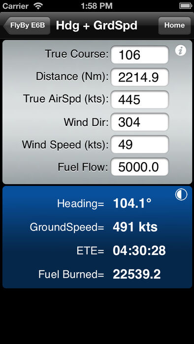
- Find Heading, Ground Speed, ETE and Fuel Burned
Time-Speed-Distance:
- Find Estimated Time Enroute
- Find Ground Speed
- Find Distance
- Find Fuel Time
- Find Fuel Flow
- Find Fuel Burned
- Find Estimated Time of Arrival
- Journey Log Time
- Time Adder
- Fixed GroundSpeed (Find a True Airspeed given a track, wind and required groundspeed)
Altitude Calculations:
- Density Altitude
- Pressure Altitude
- True Altitude
- Cold Temperature Altitude Correction
Vertical Navigation Calculations:
- Distance and Time using Altitude Change, Ground Speed, Vertical Speed
- Rate of Descent using Altitude Change, Ground Speed, Distance
- Rate of Descent using Altitude Change, Ground Speed, Descent Angle
- Feet/Nm using Vertical Speed, Ground Speed
- Feet/Nm (%) using Gradient %, Ground Speed
- Rate of Climb using Required Climb Gradient and Ground Speed
- SCDA (Constant Descent Angle)
- VDP (Visual Descent Point)
- VPA Deviation (Vertical Path Angle Deviation)
Navigation Calculations:
- Critical Point
- Point of No Return
- Time to Minimum Descent Altitude
- Track and Distance between two points with map plotting of the great circle track. Map plotting includes movable pin locations with instant trip information: Distance, Track and time enroute.
- Map GPS mode. Displays device Speed, True Course, Altitude, Distance Remaining, Track to Destination, cross track error, estimated time remaining and estimated time of arrival.
- Map closest airport feature will display airports close to your current GPS location or a dropped pin location.
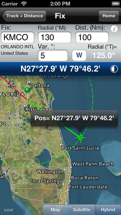
- Fix. Calculate a map point based on a Fix, Radial and Distance.
- Rate One Turn
- Radius of Turn
- Turning Stall Speed
- DME Arc distance and time.
Conversions:
- Distance:
Nautical Miles/ Knots
Statute Miles/ Mph
Kilometers/ Kph
Feet
Meters
Meters/Second
Feet/Second
- Volume:
US Gallons
Imperial Gallons
Liters
- Temperature:
Celsius
Fahrenheit
Kelvin
- Weight:
Pounds
Kilograms
- Altimeter:
Inches Hg
Millibars/Hectopascals
mmHg
- Fuel, Temperature Corrected, JetA, JetB, AvGas:
US Gallons
Imperial Gallons
Liters
Pounds
Kilograms
- QFE/QNH airfield altitude conversion
- DMS/DM.m/DM.m and D.d coordinate conversion
- VNAV
Gradient%
Feet per NM
Angle
Weather:
- Relative Humidity, Heat Index, Cumulus cloud base, Wind Chill
- NOAA METAR and TAF access
- ISA Temperature Deviation
Other Functions:
- Linear Interpolation
- Minimum Floor Load Limit (Cargo)
- Maximum Cargo Weight
- Runway Slope
- PAX Weight
- Sunrise/Sunset: Civil Day/Night, Azimuth, Apex, Elevation, for any location and time/date. Includes a unique sunset ETA function that calculates your current flights sunset time. Let your crew and passengers know when that amazing sunset photo opportunity will happen!
更新履歴
Thanks as always for all your feedback and suggestions.
This version update includes many Cold Weather Altitude function additions and enhancements. If you have a large number of approaches saved you can now quickly organize them with the automatic sort feature.
v2.61 February 2015
Cold Weather Altitude function:
-Added "Sort" feature to automatically sort the airport list.
-Added 100 NM Safe, TOCA (Take-off Obstacle Correction Altitude), and a custom altitude.
-Added iPad Chart View to easily visualize corrected approach altitudes.
- Added iPhone 6 Plus images.
- Enhanced Favorite menu icons. "Add to Favorite" star button added to all function screens. If you find a function you want quick access to you can select the Favorite "star" right from the function screen.
- Enabled swipe left and edit to delete favorite item.
- Fixed main menu background image not updating on iPhone.
- Updated World Magnetic Variation model years 2015-2019.
If you are considering a career in aviation FlyBy E6B has functions that you can use in every aircraft you will fly.
Always improving:
FlyBy E6B was one of the very first applications of its kind published for the Palm Pilot. Used by thousands of pilots the world over, it has evolved from the suggestions and feedback we have received.
Please select the "Show All Versions" item on this page to see all the features we have added from suggestions we have received.
Please visit our web site for more detail and screen shots.
FlyBy E6B Features (60+):
Airspeed Calculations:
- True Airspeed using Calibrated Airspeed
- True Airspeed using Mach#
- Calibrated Airspeed using TAS
- IAS Using MACH#
- Equivalent Airspeed using CAS
- Mach# Using TAS
- Mach Crossover Altitude
- Planned MACH#
- Planned TAS
- Vref CAS
Wind Calculation:
- Find Wind Direction and Speed
- Find Wind Component (headwind and crosswind)
Heading and Ground Speed:
- Find Heading, Ground Speed, ETE and Fuel Burned
Time-Speed-Distance:
- Find Estimated Time Enroute
- Find Ground Speed
- Find Distance
- Find Fuel Time
- Find Fuel Flow
- Find Fuel Burned
- Find Estimated Time of Arrival
- Journey Log Time
- Time Adder
- Fixed GroundSpeed (Find a True Airspeed given a track, wind and required groundspeed)
Altitude Calculations:
- Density Altitude
- Pressure Altitude
- True Altitude
- Cold Temperature Altitude Correction
Vertical Navigation Calculations:
- Distance and Time using Altitude Change, Ground Speed, Vertical Speed
- Rate of Descent using Altitude Change, Ground Speed, Distance
- Rate of Descent using Altitude Change, Ground Speed, Descent Angle
- Feet/Nm using Vertical Speed, Ground Speed
- Feet/Nm (%) using Gradient %, Ground Speed
- Rate of Climb using Required Climb Gradient and Ground Speed
- SCDA (Constant Descent Angle)
- VDP (Visual Descent Point)
- VPA Deviation (Vertical Path Angle Deviation)
Navigation Calculations:
- Critical Point
- Point of No Return
- Time to Minimum Descent Altitude
- Track and Distance between two points with map plotting of the great circle track. Map plotting includes movable pin locations with instant trip information: Distance, Track and time enroute.
- Map GPS mode. Displays device Speed, True Course, Altitude, Distance Remaining, Track to Destination, cross track error, estimated time remaining and estimated time of arrival.
- Map closest airport feature will display airports close to your current GPS location or a dropped pin location.
- Fix. Calculate a map point based on a Fix, Radial and Distance.
- Rate One Turn
- Radius of Turn
- Turning Stall Speed
- DME Arc distance and time.
Conversions:
- Distance:
Nautical Miles/ Knots
Statute Miles/ Mph
Kilometers/ Kph
Feet
Meters
Meters/Second
Feet/Second
- Volume:
US Gallons
Imperial Gallons
Liters
- Temperature:
Celsius
Fahrenheit
Kelvin
- Weight:
Pounds
Kilograms
- Altimeter:
Inches Hg
Millibars/Hectopascals
mmHg
- Fuel, Temperature Corrected, JetA, JetB, AvGas:
US Gallons
Imperial Gallons
Liters
Pounds
Kilograms
- QFE/QNH airfield altitude conversion
- DMS/DM.m/DM.m and D.d coordinate conversion
- VNAV
Gradient%
Feet per NM
Angle
Weather:
- Relative Humidity, Heat Index, Cumulus cloud base, Wind Chill
- NOAA METAR and TAF access
- ISA Temperature Deviation
Other Functions:
- Linear Interpolation
- Minimum Floor Load Limit (Cargo)
- Maximum Cargo Weight
- Runway Slope
- PAX Weight
- Sunrise/Sunset: Civil Day/Night, Azimuth, Apex, Elevation, for any location and time/date. Includes a unique sunset ETA function that calculates your current flights sunset time. Let your crew and passengers know when that amazing sunset photo opportunity will happen!
更新履歴
Thanks as always for all your feedback and suggestions.
This version update includes many Cold Weather Altitude function additions and enhancements. If you have a large number of approaches saved you can now quickly organize them with the automatic sort feature.
v2.61 February 2015
Cold Weather Altitude function:
-Added "Sort" feature to automatically sort the airport list.
-Added 100 NM Safe, TOCA (Take-off Obstacle Correction Altitude), and a custom altitude.
-Added iPad Chart View to easily visualize corrected approach altitudes.
- Added iPhone 6 Plus images.
- Enhanced Favorite menu icons. "Add to Favorite" star button added to all function screens. If you find a function you want quick access to you can select the Favorite "star" right from the function screen.
- Enabled swipe left and edit to delete favorite item.
- Fixed main menu background image not updating on iPhone.
- Updated World Magnetic Variation model years 2015-2019.
ブログパーツ第二弾を公開しました!ホームページでアプリの順位・価格・周辺ランキングをご紹介頂けます。
ブログパーツ第2弾!
アプリの周辺ランキングを表示するブログパーツです。価格・順位共に自動で最新情報に更新されるのでアプリの状態チェックにも最適です。
ランキング圏外の場合でも周辺ランキングの代わりに説明文を表示にするので安心です。
サンプルが気に入りましたら、下に表示されたHTMLタグをそのままページに貼り付けることでご利用頂けます。ただし、一般公開されているページでご使用頂かないと表示されませんのでご注意ください。
幅200px版
幅320px版
お気に入りのアプリをご紹介頂くためのブログパーツです。アプリの価格や順位表示は毎日自動更新♪
サンプルが気に入りましたら、下に表示されたHTMLタグをそのままページに貼り付けることでご利用頂けます。
※配信を停止させていただく可能性もございますので、タグの改変はご遠慮ください。

Now Loading...

「iPhone & iPad アプリランキング」は、最新かつ詳細なアプリ情報をご紹介しているサイトです。
お探しのアプリに出会えるように様々な切り口でページをご用意しております。
「メニュー」よりぜひアプリ探しにお役立て下さい。
Presents by $$308413110 スマホからのアクセスにはQRコードをご活用ください。 →
Now loading...