Hunting Map - Minnesota GPS |
| この情報はストアのものより古い可能性がございます。 | ||||
|
価格 | 600円 | ダウンロード |
|
|---|---|---|---|---|
| ジャンル | ナビゲーション | |||
サイズ | 168.2MB (ダウンロードにWIFIが必要) | |||
| 開発者 | Flytomap | |||
| 順位 |
| |||
| リリース日 | 2010-01-21 07:54:59 | 評価 | 評価が取得できませんでした。 | |
| 互換性 | iOS 9.0以降が必要です。 iPhone、iPad および iPod touch 対応。 | |||
TRY before BUY
Try now the new FlyToMap web viewer to see all available maps worldwide.
Visit viewer.flytomap.com
"With Latest Updated information"
!! Watch "Flytomap GPS" app video on www.flytomap.com and www.youtube.com !!
iHunt - Pennsylvania is the best hunting map product available today on the market.
You can Navigate in real time looking your position on the map, you don't need internet connection, switch off the 3G and double your iPhone battery life.
It is a collection of best hunting maps available for Pennsylvania.
- State Game Lands
- State Forest Lands
- State Parks
- the Allegheny National Forest
- the Erie National Wildlife Refuge
- Cooperative Farm-Game Program
- Cooperative Forest-Game Program
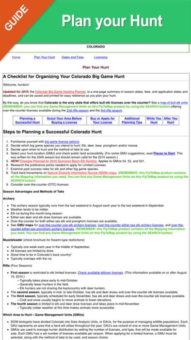
A full hunting guide that you can explore like an internet page, BUT WITHOUT ANY INTERNET CONNECTION:
- Hunting in Pennsylvania general information
- Where to Hunt ?
- Seasons and Limits for each hunting activity
- Laws
- Licensing (License Applications, License Types, License Fees)
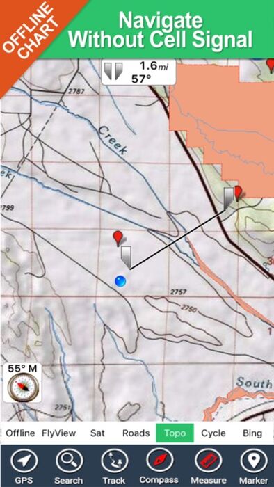
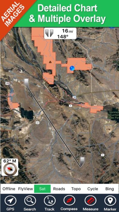
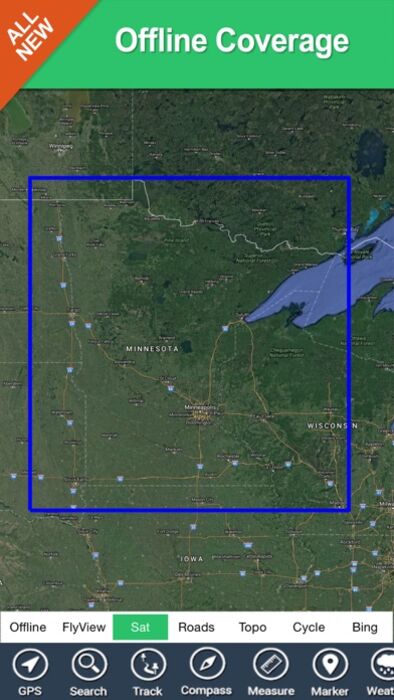
All the above fully integrated in a very detailed topographic map, using the same symbology of the best local hunting paper maps, including:
- Parks and Forests boundaries
- Natural areas boudaries
- Elevation contours (10mt step)
- roads
- trails
- very detailed Mines areas
- rivers and lakes
- Mountain peaks
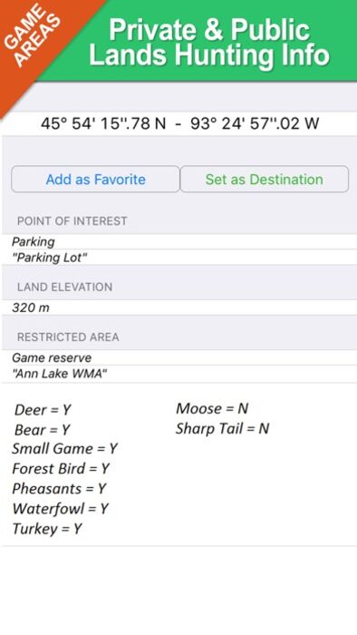
- Point of Interests
Imagine the above mapping data, fully availabe on your iPhone, without the need of any internet connection, used in conjunction with great application functionalities like:
- Shot your favorite picture and store its position on your map. Add a name and comments and retrive it in the future (....shortly you will be also able to share both pictures and position with your friends....)
- Search for any place, including hunting areas, or your favorite spots and retrive them on the map together with your pictures
-Track and store your path.
-Use latitudes and longitudes to go to your favorite places
- See your position on the map in real time, using your iPhone GPS and without any internet connection
- and many others....
Note:
"Continued use of GPS running in the background can dramatically decrease battery life."
"Turn off GPS when not in use"
更新履歴
Track improvement
Marine Weather algorithm update
Try now the new FlyToMap web viewer to see all available maps worldwide.
Visit viewer.flytomap.com
"With Latest Updated information"
!! Watch "Flytomap GPS" app video on www.flytomap.com and www.youtube.com !!
iHunt - Pennsylvania is the best hunting map product available today on the market.
You can Navigate in real time looking your position on the map, you don't need internet connection, switch off the 3G and double your iPhone battery life.
It is a collection of best hunting maps available for Pennsylvania.
- State Game Lands
- State Forest Lands
- State Parks
- the Allegheny National Forest
- the Erie National Wildlife Refuge
- Cooperative Farm-Game Program
- Cooperative Forest-Game Program
A full hunting guide that you can explore like an internet page, BUT WITHOUT ANY INTERNET CONNECTION:
- Hunting in Pennsylvania general information
- Where to Hunt ?
- Seasons and Limits for each hunting activity
- Laws
- Licensing (License Applications, License Types, License Fees)
All the above fully integrated in a very detailed topographic map, using the same symbology of the best local hunting paper maps, including:
- Parks and Forests boundaries
- Natural areas boudaries
- Elevation contours (10mt step)
- roads
- trails
- very detailed Mines areas
- rivers and lakes
- Mountain peaks
- Point of Interests
Imagine the above mapping data, fully availabe on your iPhone, without the need of any internet connection, used in conjunction with great application functionalities like:
- Shot your favorite picture and store its position on your map. Add a name and comments and retrive it in the future (....shortly you will be also able to share both pictures and position with your friends....)
- Search for any place, including hunting areas, or your favorite spots and retrive them on the map together with your pictures
-Track and store your path.
-Use latitudes and longitudes to go to your favorite places
- See your position on the map in real time, using your iPhone GPS and without any internet connection
- and many others....
Note:
"Continued use of GPS running in the background can dramatically decrease battery life."
"Turn off GPS when not in use"
更新履歴
Track improvement
Marine Weather algorithm update
ブログパーツ第二弾を公開しました!ホームページでアプリの順位・価格・周辺ランキングをご紹介頂けます。
ブログパーツ第2弾!
アプリの周辺ランキングを表示するブログパーツです。価格・順位共に自動で最新情報に更新されるのでアプリの状態チェックにも最適です。
ランキング圏外の場合でも周辺ランキングの代わりに説明文を表示にするので安心です。
サンプルが気に入りましたら、下に表示されたHTMLタグをそのままページに貼り付けることでご利用頂けます。ただし、一般公開されているページでご使用頂かないと表示されませんのでご注意ください。
幅200px版
幅320px版
お気に入りのアプリをご紹介頂くためのブログパーツです。アプリの価格や順位表示は毎日自動更新♪
サンプルが気に入りましたら、下に表示されたHTMLタグをそのままページに貼り付けることでご利用頂けます。
※配信を停止させていただく可能性もございますので、タグの改変はご遠慮ください。

Now Loading...

「iPhone & iPad アプリランキング」は、最新かつ詳細なアプリ情報をご紹介しているサイトです。
お探しのアプリに出会えるように様々な切り口でページをご用意しております。
「メニュー」よりぜひアプリ探しにお役立て下さい。
Presents by $$308413110 スマホからのアクセスにはQRコードをご活用ください。 →
Now loading...