NOAA Nautical Charts & Map |
| この情報はストアのものより古い可能性がございます。 | ||||
|
価格 | 900円 | ダウンロード |
|
|---|---|---|---|---|
| ジャンル | ナビゲーション | |||
サイズ | 894.0KB | |||
| 開発者 | Amni LLC | |||
| 順位 |
| |||
| リリース日 | 2020-11-16 17:00:00 | 評価 | 評価が取得できませんでした。 | |
| 互換性 | iOS 13.0以降が必要です。 iPhone、iPad および iPod touch 対応。 | |||
The premium and best app for Nautical Navigation Charts and Maps:
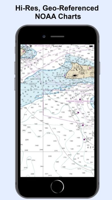
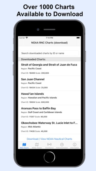
* 1000+ NOAA Raster Navigational Charts (RNC) available for download and for offline use. RNC are high resolution, full-color, geo-referenced, digital images of NOAA paper nautical charts.
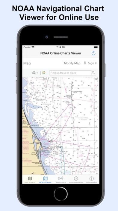
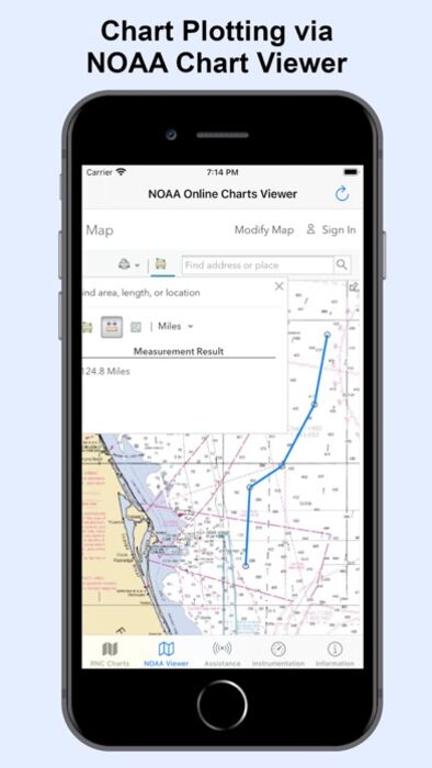
* 1000+ NOAA Navigational Charts for online use that includes GPS location, navigation plotting and more.
* Basic instrumentation - GPS location, Longitude, Latitude and Device Compass.
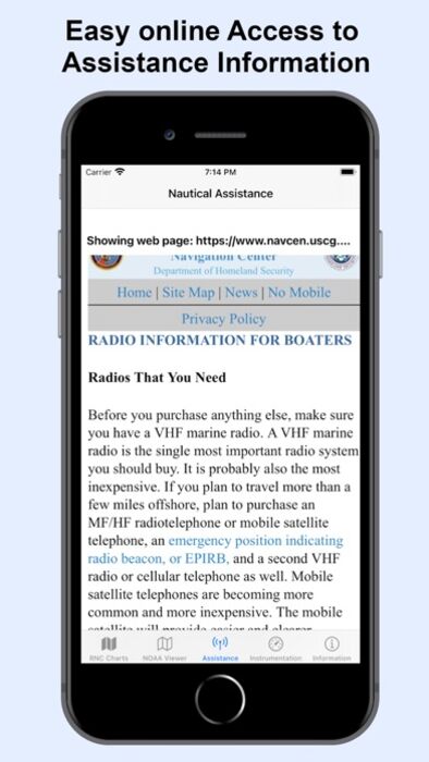
* Assitance Support - Link to Navigation Center, Radio Information.for Boaters.
Additional information about the charts and data provided with this app:
NOAA RNC® charts are full-color, geo-referenced, digital images of NOAA paper nautical charts.
RNCs can be used with global positioning system (GPS) enabled electronic chart systems or other “chart plotter” display systems to provide real-time vessel positioning.
NOAA RNCs comply with the International Hydrographic Organization RNC Product Specification.
RNCs are approved for use by IMO ECDIS mandated vessels only if adequate ENC data is not available. Since complete ENC coverage is available in all U.S. waters, vessels required to use ECDIS may not navigate with NOAA RNCs.
NOAA RNCs DO NOT meet USCG chart carriage requirements for commercial vessels.
NOAA RNCs may be downloaded free from the NOAA chart locator or the NOAA nautical chart catalog.
----------
Electronic Navigational Charts (ENC) are vector data sets that support all types of marine navigation. Originally designed for large commercial vessels using a sophisticated navigational computer called an Electronic Chart Display and Information System (ECDIS), ENCs are now also being used on simpler electronic chart systems and “chart plotters” on many types of ships and by recreational boaters. NOAA ENCs help provide real-time ship positioning, as well as collision and grounding avoidance.
NOAA ENCs comply with the International Hydrographic Organization ENC Product Specification. ENCs are produced around the world by many different countries’ national hydrographic or charting agencies. NOAA maintains more than 1,000 NOAA ENC® datasets over U.S. coastal waters and the Great Lakes. The U.S. Army Corps of Engineers produces a similar product, called Inland ENC (IENC) for many U.S. rivers.
更新履歴
RNC Viewer integration for online Charts
* 1000+ NOAA Raster Navigational Charts (RNC) available for download and for offline use. RNC are high resolution, full-color, geo-referenced, digital images of NOAA paper nautical charts.
* 1000+ NOAA Navigational Charts for online use that includes GPS location, navigation plotting and more.
* Basic instrumentation - GPS location, Longitude, Latitude and Device Compass.
* Assitance Support - Link to Navigation Center, Radio Information.for Boaters.
Additional information about the charts and data provided with this app:
NOAA RNC® charts are full-color, geo-referenced, digital images of NOAA paper nautical charts.
RNCs can be used with global positioning system (GPS) enabled electronic chart systems or other “chart plotter” display systems to provide real-time vessel positioning.
NOAA RNCs comply with the International Hydrographic Organization RNC Product Specification.
RNCs are approved for use by IMO ECDIS mandated vessels only if adequate ENC data is not available. Since complete ENC coverage is available in all U.S. waters, vessels required to use ECDIS may not navigate with NOAA RNCs.
NOAA RNCs DO NOT meet USCG chart carriage requirements for commercial vessels.
NOAA RNCs may be downloaded free from the NOAA chart locator or the NOAA nautical chart catalog.
----------
Electronic Navigational Charts (ENC) are vector data sets that support all types of marine navigation. Originally designed for large commercial vessels using a sophisticated navigational computer called an Electronic Chart Display and Information System (ECDIS), ENCs are now also being used on simpler electronic chart systems and “chart plotters” on many types of ships and by recreational boaters. NOAA ENCs help provide real-time ship positioning, as well as collision and grounding avoidance.
NOAA ENCs comply with the International Hydrographic Organization ENC Product Specification. ENCs are produced around the world by many different countries’ national hydrographic or charting agencies. NOAA maintains more than 1,000 NOAA ENC® datasets over U.S. coastal waters and the Great Lakes. The U.S. Army Corps of Engineers produces a similar product, called Inland ENC (IENC) for many U.S. rivers.
更新履歴
RNC Viewer integration for online Charts
ブログパーツ第二弾を公開しました!ホームページでアプリの順位・価格・周辺ランキングをご紹介頂けます。
ブログパーツ第2弾!
アプリの周辺ランキングを表示するブログパーツです。価格・順位共に自動で最新情報に更新されるのでアプリの状態チェックにも最適です。
ランキング圏外の場合でも周辺ランキングの代わりに説明文を表示にするので安心です。
サンプルが気に入りましたら、下に表示されたHTMLタグをそのままページに貼り付けることでご利用頂けます。ただし、一般公開されているページでご使用頂かないと表示されませんのでご注意ください。
幅200px版
幅320px版
お気に入りのアプリをご紹介頂くためのブログパーツです。アプリの価格や順位表示は毎日自動更新♪
サンプルが気に入りましたら、下に表示されたHTMLタグをそのままページに貼り付けることでご利用頂けます。
※配信を停止させていただく可能性もございますので、タグの改変はご遠慮ください。

Now Loading...

「iPhone & iPad アプリランキング」は、最新かつ詳細なアプリ情報をご紹介しているサイトです。
お探しのアプリに出会えるように様々な切り口でページをご用意しております。
「メニュー」よりぜひアプリ探しにお役立て下さい。
Presents by $$308413110 スマホからのアクセスにはQRコードをご活用ください。 →
Now loading...