Wonderland Trail by Tami Asars |
| このアプリは現在ストアで閲覧することができません。 | ||||

|
価格 | 1200円 | ダウンロード |
|
|---|---|---|---|---|
| ジャンル | 旅行 | |||
サイズ | 14.0MB | |||
| 開発者 | Guthook Hikes, LLC | |||
| 順位 |
| |||
| リリース日 | 2016-04-14 10:34:37 | 評価 | 評価が取得できませんでした。 | |
| 互換性 | iOS 8.1以降が必要です。 iPhone、iPad および iPod touch 対応。 | |||
|
||||
Wonderland Trail by Tami Asars is built through a collaboration of the creators of Guthook's Guides hiking guide apps and Tami Asars, author of the popular guidebook "Hiking the Wonderland Trail: The Complete Guide to Mount Rainier's Premier Trail."
The Wonderland Trail app is a GPS- and map-based guide for your Wonderland Trail hiking experience.
NO MOBILE OR INTERNET service is required to use it after the initial setup.
Features:
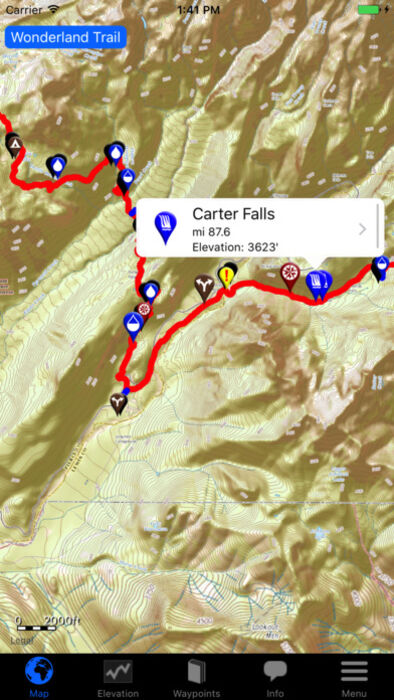
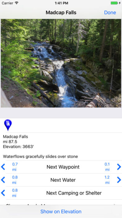
*GPS-enabled map of the Wonderland Trail and side trails
*400+ waypoints with over 500 photos
*Offline topo maps and satellite imagery.
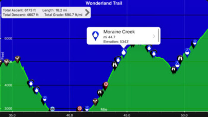
*GPS-enabled elevation profile with waypoints
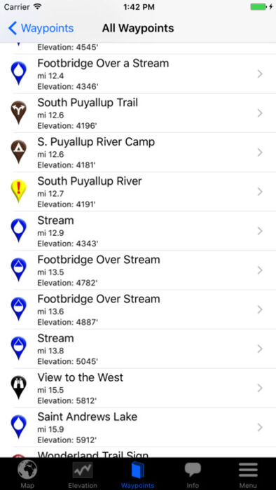
*GPS-enabled data book listing of all waypoints
The types of waypoints include:
-->Water sources (including the reliability of each water source)
-->Designated Wonderland Trail camping sites
-->Trail junctions
-->Parking areas
-->Ranger cabins
-->Road crossings
-->Natural landmarks
-->Privies
-->Views
更新履歴
v6.0:
-Major interface update, with a new main menu, de-cluttered map and elevation views, and more intuitive settings, route, and account management.
-Custom routes now have directional arrows to show which way you’re heading.
-Info display in Elevation Profile shows ascent, descent, length, and grade of currently displayed trail section.
-Settings include an option to keep map and elevation views synced at all times.
-Stability and speed improvements.
-Groundwork for several other new features to be added this year!
As always, you can email us directly (support@atlasguides.com) if you want to leave feedback that we can respond to (App Store reviews don’t allow us to respond since we don’t get your contact info).
The Wonderland Trail app is a GPS- and map-based guide for your Wonderland Trail hiking experience.
NO MOBILE OR INTERNET service is required to use it after the initial setup.
Features:
*GPS-enabled map of the Wonderland Trail and side trails
*400+ waypoints with over 500 photos
*Offline topo maps and satellite imagery.
*GPS-enabled elevation profile with waypoints
*GPS-enabled data book listing of all waypoints
The types of waypoints include:
-->Water sources (including the reliability of each water source)
-->Designated Wonderland Trail camping sites
-->Trail junctions
-->Parking areas
-->Ranger cabins
-->Road crossings
-->Natural landmarks
-->Privies
-->Views
更新履歴
v6.0:
-Major interface update, with a new main menu, de-cluttered map and elevation views, and more intuitive settings, route, and account management.
-Custom routes now have directional arrows to show which way you’re heading.
-Info display in Elevation Profile shows ascent, descent, length, and grade of currently displayed trail section.
-Settings include an option to keep map and elevation views synced at all times.
-Stability and speed improvements.
-Groundwork for several other new features to be added this year!
As always, you can email us directly (support@atlasguides.com) if you want to leave feedback that we can respond to (App Store reviews don’t allow us to respond since we don’t get your contact info).
ブログパーツ第二弾を公開しました!ホームページでアプリの順位・価格・周辺ランキングをご紹介頂けます。
ブログパーツ第2弾!
アプリの周辺ランキングを表示するブログパーツです。価格・順位共に自動で最新情報に更新されるのでアプリの状態チェックにも最適です。
ランキング圏外の場合でも周辺ランキングの代わりに説明文を表示にするので安心です。
サンプルが気に入りましたら、下に表示されたHTMLタグをそのままページに貼り付けることでご利用頂けます。ただし、一般公開されているページでご使用頂かないと表示されませんのでご注意ください。
幅200px版
幅320px版
お気に入りのアプリをご紹介頂くためのブログパーツです。アプリの価格や順位表示は毎日自動更新♪
サンプルが気に入りましたら、下に表示されたHTMLタグをそのままページに貼り付けることでご利用頂けます。
※配信を停止させていただく可能性もございますので、タグの改変はご遠慮ください。

Now Loading...

「iPhone & iPad アプリランキング」は、最新かつ詳細なアプリ情報をご紹介しているサイトです。
お探しのアプリに出会えるように様々な切り口でページをご用意しております。
「メニュー」よりぜひアプリ探しにお役立て下さい。
Presents by $$308413110 スマホからのアクセスにはQRコードをご活用ください。 →
Now loading...