Yorkshire Dales Maps Offline |


|
価格 | 300円 | ダウンロード |
|
|---|---|---|---|---|
| ジャンル | ナビゲーション | |||
サイズ | 551.5MB (ダウンロードにWIFIが必要) | |||
| 開発者 | JOMO Solutions Ltd | |||
| 順位 |
| |||
| リリース日 | 2015-05-09 12:38:47 | 評価 | 評価が取得できませんでした。 | |
| 互換性 | iOS 8.0以降が必要です。 iPhone、iPad および iPod touch 対応。 | |||
From the producers of GB Maps (featured in Ordnance Survey's OS OpenData innovative application showcase)
Beautifully detailed maps supplied by Ordnance Survey.
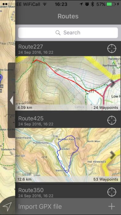
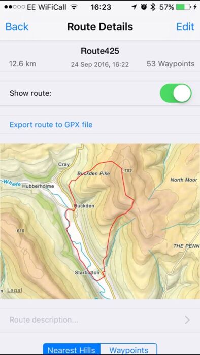
Yorkshire Dales Maps provides a useful offline mapping reference and navigation aid whilst travelling throughout the Yorkshire Dales by footpath, road, rail, canal, lake and river. Intuitive route and waypoint management features are implemented enabling creation, modification, deletion, import and export of routes.
A powerful offline search facility can locate places, roads, post codes and hills within the region. Worldwide online Apple maps (Standard, Satellite and Hybrid). Map features that you are used to with Apple maps are available on both offline and online maps as well as providing 3D buildings on Apple maps (where available).
Maps
7 different levels of offline 2014/5 Ordnance Survey map detail from national overview to street view within the region. (No data connection required)
Progressively more detailed maps are automatically loaded as the map view is zoomed. The OS recommended viewing scales for the more detailed maps are approximately as follows:
1:1000,000 (Whole of GB is covered)
1:250,000
1:50,000
1:25,000
1:10,000 ( Roads/streets are labelled)
The map region of the more detailed maps covers a rectangular region around the national park boundary (ref. http://jomosolutions.com/Maps)
- Contours with height information and annotated height points
- Extensive footpaths from ©OpenStreetMap contributors
- National Park boundary demarkation
App
- Route/Waypoint management
- Offline search functionality with searchable locations (places, roads, post codes and hills). (For the place search a location's latitude and longitude is accurate to 0.1 of a minute of the centre point of the 1x1 km National Grid square in which the name falls)
- Detailed hill information, including height, OS Grid Ref, latitude and longitude, region, parent, classification, drop and hill specific links to Streetmap, Geograph and Hill Bagging web sites
- Display of current GPS position as OS Grid Reference or WGS84 latitude and longitude
- "Share My Location" allowing users to share an image of their current location and location references. Buttons are provided to share location information by Facebook, Twitter, iMessage/SMS and e-mail
- Online access to worldwide Apple Standard, Satellite and Hybrid maps
- Apple 3D Buildings are displayed on Apple Standard maps
- Apple maps contain Points of Interest
- User location can be tracked with or without heading on all online and offline maps (GPS capable devices only)
- Display of scale bar in either metric or imperial units
- Display of current speed
- Zoom, pan, rotation of all maps
- Pitch of Apple Standard and Ordnance Survey maps
- Selection of current location annotation for display of speed and location data
- User setting for speed display in Miles per Hour (mph) or Kilometres per Hour (kph)
- Selection of search result pin annotations to display location information
- Collective deletion of search result annotation pins
- A user guide is provided within
The OS search data was published by Ordnance Survey in 2014.
Extracts from "The Database of British and Irish Hills" v14 published 22/04/2014 (ref. http://www.hills-database.co.uk/index.html )
No warranty
The data is supplied by Apple, Ordnance Survey, contributors to OpenStreetMap and Database of British and Irish Hills.
The Information is licensed 'as is' and the Information Provider and/or Licensor excludes all representations, warranties, obligations and liabilities in relation to the Information to the maximum extent permitted by law.
The Information Provider and/or Licensor are not liable for any errors or omissions in the Information and shall not be liable for any loss, injury or damage of any kind caused by its use.
This app is not a substitute for a paper map and compass.
更新履歴
Fixed intermittent failures within the search functionality.
If you like the app please leave an app review.
Beautifully detailed maps supplied by Ordnance Survey.
Yorkshire Dales Maps provides a useful offline mapping reference and navigation aid whilst travelling throughout the Yorkshire Dales by footpath, road, rail, canal, lake and river. Intuitive route and waypoint management features are implemented enabling creation, modification, deletion, import and export of routes.
A powerful offline search facility can locate places, roads, post codes and hills within the region. Worldwide online Apple maps (Standard, Satellite and Hybrid). Map features that you are used to with Apple maps are available on both offline and online maps as well as providing 3D buildings on Apple maps (where available).
Maps
7 different levels of offline 2014/5 Ordnance Survey map detail from national overview to street view within the region. (No data connection required)
Progressively more detailed maps are automatically loaded as the map view is zoomed. The OS recommended viewing scales for the more detailed maps are approximately as follows:
1:1000,000 (Whole of GB is covered)
1:250,000
1:50,000
1:25,000
1:10,000 ( Roads/streets are labelled)
The map region of the more detailed maps covers a rectangular region around the national park boundary (ref. http://jomosolutions.com/Maps)
- Contours with height information and annotated height points
- Extensive footpaths from ©OpenStreetMap contributors
- National Park boundary demarkation
App
- Route/Waypoint management
- Offline search functionality with searchable locations (places, roads, post codes and hills). (For the place search a location's latitude and longitude is accurate to 0.1 of a minute of the centre point of the 1x1 km National Grid square in which the name falls)
- Detailed hill information, including height, OS Grid Ref, latitude and longitude, region, parent, classification, drop and hill specific links to Streetmap, Geograph and Hill Bagging web sites
- Display of current GPS position as OS Grid Reference or WGS84 latitude and longitude
- "Share My Location" allowing users to share an image of their current location and location references. Buttons are provided to share location information by Facebook, Twitter, iMessage/SMS and e-mail
- Online access to worldwide Apple Standard, Satellite and Hybrid maps
- Apple 3D Buildings are displayed on Apple Standard maps
- Apple maps contain Points of Interest
- User location can be tracked with or without heading on all online and offline maps (GPS capable devices only)
- Display of scale bar in either metric or imperial units
- Display of current speed
- Zoom, pan, rotation of all maps
- Pitch of Apple Standard and Ordnance Survey maps
- Selection of current location annotation for display of speed and location data
- User setting for speed display in Miles per Hour (mph) or Kilometres per Hour (kph)
- Selection of search result pin annotations to display location information
- Collective deletion of search result annotation pins
- A user guide is provided within
The OS search data was published by Ordnance Survey in 2014.
Extracts from "The Database of British and Irish Hills" v14 published 22/04/2014 (ref. http://www.hills-database.co.uk/index.html )
No warranty
The data is supplied by Apple, Ordnance Survey, contributors to OpenStreetMap and Database of British and Irish Hills.
The Information is licensed 'as is' and the Information Provider and/or Licensor excludes all representations, warranties, obligations and liabilities in relation to the Information to the maximum extent permitted by law.
The Information Provider and/or Licensor are not liable for any errors or omissions in the Information and shall not be liable for any loss, injury or damage of any kind caused by its use.
This app is not a substitute for a paper map and compass.
更新履歴
Fixed intermittent failures within the search functionality.
If you like the app please leave an app review.
ブログパーツ第二弾を公開しました!ホームページでアプリの順位・価格・周辺ランキングをご紹介頂けます。
ブログパーツ第2弾!
アプリの周辺ランキングを表示するブログパーツです。価格・順位共に自動で最新情報に更新されるのでアプリの状態チェックにも最適です。
ランキング圏外の場合でも周辺ランキングの代わりに説明文を表示にするので安心です。
サンプルが気に入りましたら、下に表示されたHTMLタグをそのままページに貼り付けることでご利用頂けます。ただし、一般公開されているページでご使用頂かないと表示されませんのでご注意ください。
幅200px版
幅320px版
お気に入りのアプリをご紹介頂くためのブログパーツです。アプリの価格や順位表示は毎日自動更新♪
サンプルが気に入りましたら、下に表示されたHTMLタグをそのままページに貼り付けることでご利用頂けます。
※配信を停止させていただく可能性もございますので、タグの改変はご遠慮ください。

Now Loading...

「iPhone & iPad アプリランキング」は、最新かつ詳細なアプリ情報をご紹介しているサイトです。
お探しのアプリに出会えるように様々な切り口でページをご用意しております。
「メニュー」よりぜひアプリ探しにお役立て下さい。
Presents by $$308413110 スマホからのアクセスにはQRコードをご活用ください。 →
Now loading...