Pix4Dcapture |
| このアプリは現在ストアで閲覧することができません。 | ||||


|
価格 | 無料 | ダウンロード |
|
|---|---|---|---|---|
| ジャンル | ユーティリティ | |||
サイズ | 213.2MB (ダウンロードにWIFIが必要) | |||
| 開発者 | Pix4D | |||
| 順位 |
| |||
| リリース日 | 2015-01-06 13:47:44 | 評価 |
|
|
| 互換性 | iOS 10.3以降が必要です。 iPhone、iPad および iPod touch 対応。 | |||
|
||||
 (15人)
(15人)
Pix4Dcapture turns your consumer drone into a professional drone mapping tool. A free companion to Pix4D photogrammetry software, Pix4Dcapture is the perfect tool to automatically capture image data - RGB, multispectral, thermal - for optimal 3D models and maps.
Process post-flight images easily on the cloud or desktop applications, producing georeferenced maps and models that are tailored to many industry needs.
Currently, the app supports and was tested for the following drones:
• DJI
- Phantom 4 Pro V2
- Phantom 4 Pro
- Phantom 4
- Mavic Air
- Mavic Pro
- Mavic 2 Pro
- Mavic 2 Enterprise Dual (Only RGB Images)
- Inspire 1 (Pro)
- Inspire 2
- Matrice 200, 210, 210 RTK
- Matrice 100
- Matrice 600
- Phantom 3 Professional
- Phantom 3 Advanced
- Phantom 3 Standard
- Spark
• Parrot
- Anafi USA with Skycontroller 3 (RGB Images)
- Anafi with Skycontroller 3
- Anafi Thermal with Skycontroller 3 (RGB + Thermal Images)
- Bebop 2 with Skycontroller 2
- Disco-Pro AG with Skycontroller 2
- Bluegrass with Skycontroller 2
Features and benefits:
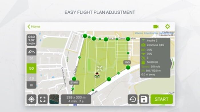
• Fully automated drone mapping
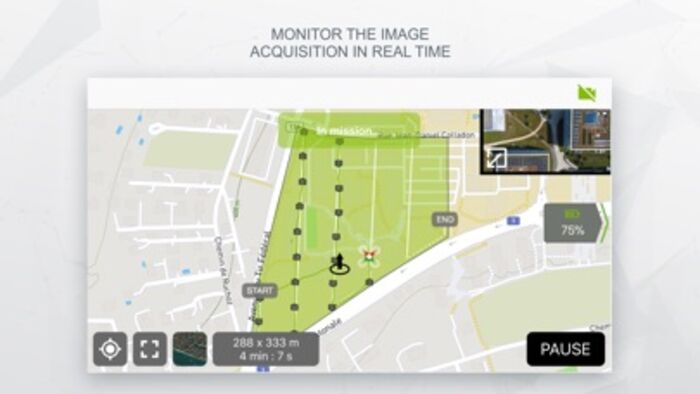
• Drone telemetry and camera live feed during the image acquisition
• Different flight plans for different needs
- Polygon Mission for general mapping
- Grid Mission for general mapping
- Double Grid Mission for better 3D model reconstruction
- Circular Mission for point-of-interest 3D model reconstruction
- Free Flight Mission for vertical object mapping with manual flight control
• Flight parameters for each mission - front & side image overlap, camera angle, altitude, GSD, flight speed - can be adjusted based on the requirements of the area.
• Save or duplicate missions to fly the same area of interest several times
• Store the basemap with your flight plan using offline maps
• Change street/satellite basemap provider
• Seamless workflow with Pix4D’s processing software
• Automated image transfer from drone-to-device
• Upload images directly from the device to Pix4D software in the cloud for processing
(license required)
Post-flight processing & analysis using Pix4D’s software on cloud or desktop:
• Achieve survey-grade results from lightweight and compact cameras to large-frame metric cameras
• Usage of Ground Control Points (GCPs) for improving the relative and absolute accuracy of the model
• Generate and modify
- Point clouds
- Orthomosaics
- Digital elevation models (DSM/DTM)
- Index maps (e.g. NDVI)
- And more
• Measure distances, surfaces, and volumes
Usage information
Ensure you have the latest firmware installed and the app is up to date.
The app follows the flight plan and does not avoid obstacles automatically.
Pix4D accepts no liability for damage, injuries or legalities from the misuse of this app. Use only in safe environments.
更新履歴
Fixed a crash when pressing the info button in the take off checklist
Process post-flight images easily on the cloud or desktop applications, producing georeferenced maps and models that are tailored to many industry needs.
Currently, the app supports and was tested for the following drones:
• DJI
- Phantom 4 Pro V2
- Phantom 4 Pro
- Phantom 4
- Mavic Air
- Mavic Pro
- Mavic 2 Pro
- Mavic 2 Enterprise Dual (Only RGB Images)
- Inspire 1 (Pro)
- Inspire 2
- Matrice 200, 210, 210 RTK
- Matrice 100
- Matrice 600
- Phantom 3 Professional
- Phantom 3 Advanced
- Phantom 3 Standard
- Spark
• Parrot
- Anafi USA with Skycontroller 3 (RGB Images)
- Anafi with Skycontroller 3
- Anafi Thermal with Skycontroller 3 (RGB + Thermal Images)
- Bebop 2 with Skycontroller 2
- Disco-Pro AG with Skycontroller 2
- Bluegrass with Skycontroller 2
Features and benefits:
• Fully automated drone mapping
• Drone telemetry and camera live feed during the image acquisition
• Different flight plans for different needs
- Polygon Mission for general mapping
- Grid Mission for general mapping
- Double Grid Mission for better 3D model reconstruction
- Circular Mission for point-of-interest 3D model reconstruction
- Free Flight Mission for vertical object mapping with manual flight control
• Flight parameters for each mission - front & side image overlap, camera angle, altitude, GSD, flight speed - can be adjusted based on the requirements of the area.
• Save or duplicate missions to fly the same area of interest several times
• Store the basemap with your flight plan using offline maps
• Change street/satellite basemap provider
• Seamless workflow with Pix4D’s processing software
• Automated image transfer from drone-to-device
• Upload images directly from the device to Pix4D software in the cloud for processing
(license required)
Post-flight processing & analysis using Pix4D’s software on cloud or desktop:
• Achieve survey-grade results from lightweight and compact cameras to large-frame metric cameras
• Usage of Ground Control Points (GCPs) for improving the relative and absolute accuracy of the model
• Generate and modify
- Point clouds
- Orthomosaics
- Digital elevation models (DSM/DTM)
- Index maps (e.g. NDVI)
- And more
• Measure distances, surfaces, and volumes
Usage information
Ensure you have the latest firmware installed and the app is up to date.
The app follows the flight plan and does not avoid obstacles automatically.
Pix4D accepts no liability for damage, injuries or legalities from the misuse of this app. Use only in safe environments.
更新履歴
Fixed a crash when pressing the info button in the take off checklist
ブログパーツ第二弾を公開しました!ホームページでアプリの順位・価格・周辺ランキングをご紹介頂けます。
ブログパーツ第2弾!
アプリの周辺ランキングを表示するブログパーツです。価格・順位共に自動で最新情報に更新されるのでアプリの状態チェックにも最適です。
ランキング圏外の場合でも周辺ランキングの代わりに説明文を表示にするので安心です。
サンプルが気に入りましたら、下に表示されたHTMLタグをそのままページに貼り付けることでご利用頂けます。ただし、一般公開されているページでご使用頂かないと表示されませんのでご注意ください。
幅200px版
幅320px版
お気に入りのアプリをご紹介頂くためのブログパーツです。アプリの価格や順位表示は毎日自動更新♪
サンプルが気に入りましたら、下に表示されたHTMLタグをそのままページに貼り付けることでご利用頂けます。
※配信を停止させていただく可能性もございますので、タグの改変はご遠慮ください。

Now Loading...

「iPhone & iPad アプリランキング」は、最新かつ詳細なアプリ情報をご紹介しているサイトです。
お探しのアプリに出会えるように様々な切り口でページをご用意しております。
「メニュー」よりぜひアプリ探しにお役立て下さい。
Presents by $$308413110 スマホからのアクセスにはQRコードをご活用ください。 →
Now loading...