John Muir Trail Map Offline |
| この情報はストアのものより古い可能性がございます。 | ||||
|
価格 | 240円 | ダウンロード |
|
|---|---|---|---|---|
| ジャンル | 旅行 | |||
サイズ | 355.1MB (ダウンロードにWIFIが必要) | |||
| 開発者 | John Buttery | |||
| 順位 |
| |||
| リリース日 | 2014-12-30 21:34:15 | 評価 | 評価が取得できませんでした。 | |
| 互換性 | iOS 8.0以降が必要です。 iPhone、iPad および iPod touch 対応。 | |||
Going hiking on the John Muir Trail?
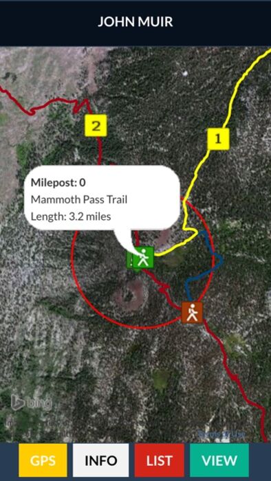
The app has trails with mile markers for all 10 trails in the system.
Agate Creek, Bishop Pass Trail, JMT Alternate, John Muir Trail, Kearsarge Trail, Mammoth Pass Trail, Panorama Trail, Whitney Trail, Whitney Portal Trail and Yosemite Valley Trail.
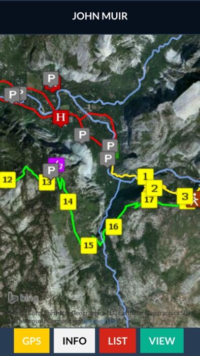
The app has all 70 campsites along the John Muir Trail.
Arrowhead Lake, Aspen Meadow, Bear Creek, Big Pete Meadow, Selden Pass, Bubbs Creek, Campground Soda Springs, Crabtree Meadow, Crabtree Ranger, Crater Creek, Deer Creek, Dollar Lake, Evolution Creek Ford, Evolution Creek, Evolution Lake, Fish Creek, Forester Pass, Garnet Lake, Gladys Lake, Glen Aulin, Grouse Meadow, Guitar Lake, Lake Marjorie, Lake Virginia, Little Yosemite Valley, Lone Pine Creek, Lower Palisade Lake, Lower Rae Lake, Lyell Fork Ford, Lyell Fork, Marie Lake, McClure Meadow, Middle Fork Kings River, Middle Rae Lake, Middle Vidette Meadow, Mono Creek, Mono Pass Trail, Muir Ranch, No Camping 4 miles N of Tuolumne Meadows, No Camping Lone Pine Creek, No Camping Mirror Lake, No Camping South Fork Kings River, No Camping Timberline Lake, North Fork Mono Creek, Palisade Creek, Piute Creek, Purple Lake, Reds Meadow Store, Rosalie Lake, Ruby Lake, Rush Creek Ford, Sallie Keyes Lake, Shadow Creek, Shadow Lake, Silver Pass Creek, Silver Pass, South Fork of Kings River, South Fork San Joaquin River, Sunrise Creek, Sunrise High Sierra Trail, Trinity Lakes Campsite, Tuolumne Meadows, Tyndall Creek, Tyndall Frog Ponds, Upper Vidette Meadow Campsite, Wallace Creek Ford, Wanda Lake, West Fork Bear Creek, Woods Creek and Wright Creek Ford
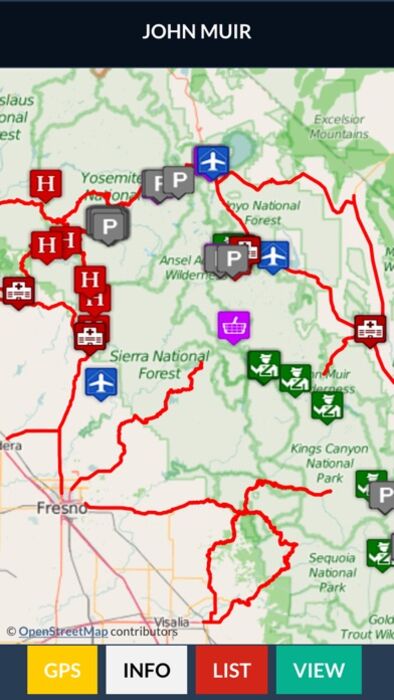
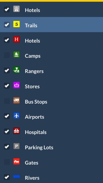
It includes all Highways, Trails, Milepost Markers, Hotels, Parking, Peaks, Parks, Gates, Airports, Hospitals and more.
John Muir Trail Map Offline has it all!!! This App works great with or without an internet connection.
Offline Maps - The app includes 2 OFFLINE maps (satellite and topo) for the region. Full GPS support. All the geographic data like trails, hotels and peaks are on your device. No internet connection required.
Online Maps - When internet is available, the App links to 3 other base maps from three internet map providers. Streets and Satellite maps are available.
The app provides Videos, Hotels, Gallery, Facebook, About Us and Contact Information. There is also info about the John Muir Trail and other geographic features.
Our cartographers design maps that look wonderful on your iPhone, iTouch and iPad.
更新履歴
Improved performance
Software update
Flat interface
New icons
The app has trails with mile markers for all 10 trails in the system.
Agate Creek, Bishop Pass Trail, JMT Alternate, John Muir Trail, Kearsarge Trail, Mammoth Pass Trail, Panorama Trail, Whitney Trail, Whitney Portal Trail and Yosemite Valley Trail.
The app has all 70 campsites along the John Muir Trail.
Arrowhead Lake, Aspen Meadow, Bear Creek, Big Pete Meadow, Selden Pass, Bubbs Creek, Campground Soda Springs, Crabtree Meadow, Crabtree Ranger, Crater Creek, Deer Creek, Dollar Lake, Evolution Creek Ford, Evolution Creek, Evolution Lake, Fish Creek, Forester Pass, Garnet Lake, Gladys Lake, Glen Aulin, Grouse Meadow, Guitar Lake, Lake Marjorie, Lake Virginia, Little Yosemite Valley, Lone Pine Creek, Lower Palisade Lake, Lower Rae Lake, Lyell Fork Ford, Lyell Fork, Marie Lake, McClure Meadow, Middle Fork Kings River, Middle Rae Lake, Middle Vidette Meadow, Mono Creek, Mono Pass Trail, Muir Ranch, No Camping 4 miles N of Tuolumne Meadows, No Camping Lone Pine Creek, No Camping Mirror Lake, No Camping South Fork Kings River, No Camping Timberline Lake, North Fork Mono Creek, Palisade Creek, Piute Creek, Purple Lake, Reds Meadow Store, Rosalie Lake, Ruby Lake, Rush Creek Ford, Sallie Keyes Lake, Shadow Creek, Shadow Lake, Silver Pass Creek, Silver Pass, South Fork of Kings River, South Fork San Joaquin River, Sunrise Creek, Sunrise High Sierra Trail, Trinity Lakes Campsite, Tuolumne Meadows, Tyndall Creek, Tyndall Frog Ponds, Upper Vidette Meadow Campsite, Wallace Creek Ford, Wanda Lake, West Fork Bear Creek, Woods Creek and Wright Creek Ford
It includes all Highways, Trails, Milepost Markers, Hotels, Parking, Peaks, Parks, Gates, Airports, Hospitals and more.
John Muir Trail Map Offline has it all!!! This App works great with or without an internet connection.
Offline Maps - The app includes 2 OFFLINE maps (satellite and topo) for the region. Full GPS support. All the geographic data like trails, hotels and peaks are on your device. No internet connection required.
Online Maps - When internet is available, the App links to 3 other base maps from three internet map providers. Streets and Satellite maps are available.
The app provides Videos, Hotels, Gallery, Facebook, About Us and Contact Information. There is also info about the John Muir Trail and other geographic features.
Our cartographers design maps that look wonderful on your iPhone, iTouch and iPad.
更新履歴
Improved performance
Software update
Flat interface
New icons
ブログパーツ第二弾を公開しました!ホームページでアプリの順位・価格・周辺ランキングをご紹介頂けます。
ブログパーツ第2弾!
アプリの周辺ランキングを表示するブログパーツです。価格・順位共に自動で最新情報に更新されるのでアプリの状態チェックにも最適です。
ランキング圏外の場合でも周辺ランキングの代わりに説明文を表示にするので安心です。
サンプルが気に入りましたら、下に表示されたHTMLタグをそのままページに貼り付けることでご利用頂けます。ただし、一般公開されているページでご使用頂かないと表示されませんのでご注意ください。
幅200px版
幅320px版
お気に入りのアプリをご紹介頂くためのブログパーツです。アプリの価格や順位表示は毎日自動更新♪
サンプルが気に入りましたら、下に表示されたHTMLタグをそのままページに貼り付けることでご利用頂けます。
※配信を停止させていただく可能性もございますので、タグの改変はご遠慮ください。

Now Loading...

「iPhone & iPad アプリランキング」は、最新かつ詳細なアプリ情報をご紹介しているサイトです。
お探しのアプリに出会えるように様々な切り口でページをご用意しております。
「メニュー」よりぜひアプリ探しにお役立て下さい。
Presents by $$308413110 スマホからのアクセスにはQRコードをご活用ください。 →
Now loading...