OkMap Mobile |
| この情報はストアのものより古い可能性がございます。 | ||||
|
価格 | 600円 | ダウンロード |
|
|---|---|---|---|---|
| ジャンル | ナビゲーション | |||
サイズ | 177.1MB (ダウンロードにWIFIが必要) | |||
| 開発者 | Gian Paolo Saliola | |||
| 順位 |
| |||
| リリース日 | 2015-01-16 14:23:56 | 評価 | 評価が取得できませんでした。 | |
| 互換性 | iOS 8.0以降が必要です。 iPhone、iPad および iPod touch 対応。 | |||
OkMap Mobile is easy to use and its features are similar to those of the most popular GPS handhelds.
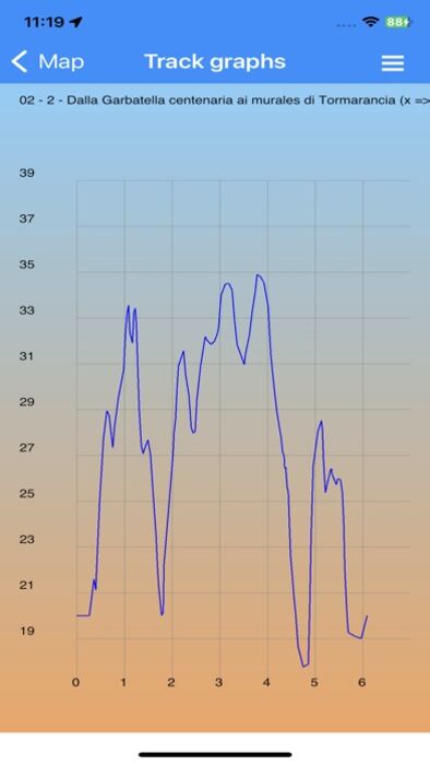
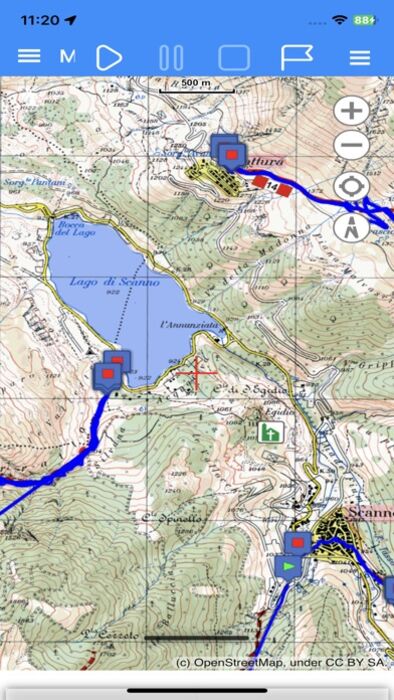
Plan your routes on the map! OkMap calculates the height differences and travel times for you and produces statistics and graphics.
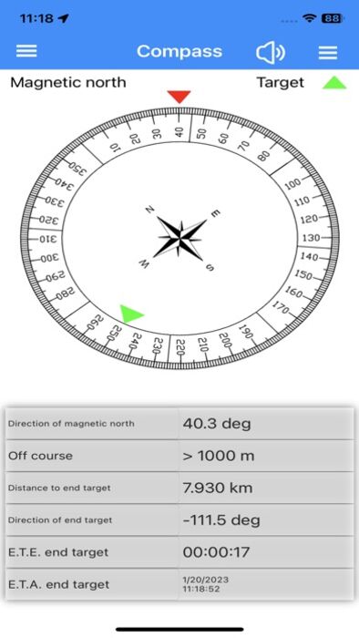
A compass shows you the direction and you will be warned if you are going off course.
OkMap is specially designed for those who do outdoor activities such as search and rescue, hiking, mountain biking, off road, boating, flying, hunting and fishing, mushroom hunting, geocaching, soft air and much more.
OkMap works with different online maps and offline custom maps in MbTiles format.
You can use your favorite digital maps both acquired and scanned!
Furthermore OkMap works with GPX files, the standard format for storing waypoints, tracks and routes.
These files can be copied to and from the PC via cable or via Google Drive.
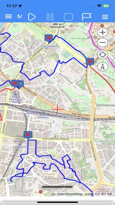
You can record the track while walking on a trail and/or follow a previously recorded or created track.
All waypoints, tracks and routes are displayed on the map; the recording track is drawn in real time.
OkMap records the tracks even in standby and with the app closed. A notification alerts you when the GPS is working.
You can create and edit waypoints, tracks and routes directly on the map.
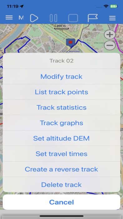
It is also possible to produce different types of statistics and graphs on your own tracks.
Finally, an augmented reality function displays all waypoints with altitude in the device's camera.
FUNCTIONS
Maps
- Offline custom map in MbTiles format
- Online maps from different TMS and WMS web servers (Google, Apple, OpenStreetMap, ESRI, Nokia, etc ...)
- Addition of new custom web servers
- 6 customizable navigation and status indicators (from over 60)
- Coordinates in different datums and formats: Degrees, Degrees-Minutes, Degrees-Minutes-Seconds, UTM, ECEF, OLC, GeoRef, USNG, MGRS, BNG, IG, metrics according to many projections
- Zoom on: GPX data, copied coordinates
- Mode: follow the user's position, distance calculation
- Grids: geographic, metric and DEM data
- Find: waypoint, track, route, address, coordinates
- Reverse geocoding
- Waypoint generation
- Download and management of elevation data (DEM) from the SRTM project
- Integration with: Google Maps, Geocaching.com, Peakfinder.org
- Download waypoints from OpenStreetMap
- Create and edit waypoints, tracks and routes on the map
Navigation
- GPS activation/deactivation
- Start, pause and stop recording of the track
- Stores waypoint at current location
- Navigate to a waypoint and follow a track or a route
- Waypoint proximity function
- Anchor alarm
- Off course alarm
- Sending values via email
- Sending current position and waypoints to a remote OkMap server
Trip Computer
- On-board computer with over 60 navigation and status indicators
Compass
- 6 customizable navigation and status indicators (from over 60)
- Graphic compass with direction of north and destination
- Speech synthesizer when pointing the device
Waypoints, Tracks and Routes
- Lists of various kinds
- Edit and delete functions
- Sorting and filtering functions
- Information detail pages
- Track graphs
- Track statistics
- Track and route inversion
- Automatic attribution of altitudes
- Travel time estimation function
Utility
- List of GPX file
- List of custom maps
- List of downloaded DEM files
- List of web maps
- List of datum
- List of projections
- Preferences
- Reset to factory settings
- Information and links
- Download the online manual
更新履歴
Updated EPSG database to version 11.016.
FIX: Display coordinates in Irish Grid format.
Plan your routes on the map! OkMap calculates the height differences and travel times for you and produces statistics and graphics.
A compass shows you the direction and you will be warned if you are going off course.
OkMap is specially designed for those who do outdoor activities such as search and rescue, hiking, mountain biking, off road, boating, flying, hunting and fishing, mushroom hunting, geocaching, soft air and much more.
OkMap works with different online maps and offline custom maps in MbTiles format.
You can use your favorite digital maps both acquired and scanned!
Furthermore OkMap works with GPX files, the standard format for storing waypoints, tracks and routes.
These files can be copied to and from the PC via cable or via Google Drive.
You can record the track while walking on a trail and/or follow a previously recorded or created track.
All waypoints, tracks and routes are displayed on the map; the recording track is drawn in real time.
OkMap records the tracks even in standby and with the app closed. A notification alerts you when the GPS is working.
You can create and edit waypoints, tracks and routes directly on the map.
It is also possible to produce different types of statistics and graphs on your own tracks.
Finally, an augmented reality function displays all waypoints with altitude in the device's camera.
FUNCTIONS
Maps
- Offline custom map in MbTiles format
- Online maps from different TMS and WMS web servers (Google, Apple, OpenStreetMap, ESRI, Nokia, etc ...)
- Addition of new custom web servers
- 6 customizable navigation and status indicators (from over 60)
- Coordinates in different datums and formats: Degrees, Degrees-Minutes, Degrees-Minutes-Seconds, UTM, ECEF, OLC, GeoRef, USNG, MGRS, BNG, IG, metrics according to many projections
- Zoom on: GPX data, copied coordinates
- Mode: follow the user's position, distance calculation
- Grids: geographic, metric and DEM data
- Find: waypoint, track, route, address, coordinates
- Reverse geocoding
- Waypoint generation
- Download and management of elevation data (DEM) from the SRTM project
- Integration with: Google Maps, Geocaching.com, Peakfinder.org
- Download waypoints from OpenStreetMap
- Create and edit waypoints, tracks and routes on the map
Navigation
- GPS activation/deactivation
- Start, pause and stop recording of the track
- Stores waypoint at current location
- Navigate to a waypoint and follow a track or a route
- Waypoint proximity function
- Anchor alarm
- Off course alarm
- Sending values via email
- Sending current position and waypoints to a remote OkMap server
Trip Computer
- On-board computer with over 60 navigation and status indicators
Compass
- 6 customizable navigation and status indicators (from over 60)
- Graphic compass with direction of north and destination
- Speech synthesizer when pointing the device
Waypoints, Tracks and Routes
- Lists of various kinds
- Edit and delete functions
- Sorting and filtering functions
- Information detail pages
- Track graphs
- Track statistics
- Track and route inversion
- Automatic attribution of altitudes
- Travel time estimation function
Utility
- List of GPX file
- List of custom maps
- List of downloaded DEM files
- List of web maps
- List of datum
- List of projections
- Preferences
- Reset to factory settings
- Information and links
- Download the online manual
更新履歴
Updated EPSG database to version 11.016.
FIX: Display coordinates in Irish Grid format.
ブログパーツ第二弾を公開しました!ホームページでアプリの順位・価格・周辺ランキングをご紹介頂けます。
ブログパーツ第2弾!
アプリの周辺ランキングを表示するブログパーツです。価格・順位共に自動で最新情報に更新されるのでアプリの状態チェックにも最適です。
ランキング圏外の場合でも周辺ランキングの代わりに説明文を表示にするので安心です。
サンプルが気に入りましたら、下に表示されたHTMLタグをそのままページに貼り付けることでご利用頂けます。ただし、一般公開されているページでご使用頂かないと表示されませんのでご注意ください。
幅200px版
幅320px版
お気に入りのアプリをご紹介頂くためのブログパーツです。アプリの価格や順位表示は毎日自動更新♪
サンプルが気に入りましたら、下に表示されたHTMLタグをそのままページに貼り付けることでご利用頂けます。
※配信を停止させていただく可能性もございますので、タグの改変はご遠慮ください。

Now Loading...

「iPhone & iPad アプリランキング」は、最新かつ詳細なアプリ情報をご紹介しているサイトです。
お探しのアプリに出会えるように様々な切り口でページをご用意しております。
「メニュー」よりぜひアプリ探しにお役立て下さい。
Presents by $$308413110 スマホからのアクセスにはQRコードをご活用ください。 →
Now loading...