GeoFlyer Europe 3D Maps |
| この情報はストアのものより古い可能性がございます。 | ||||
|
価格 | 600円 | ダウンロード |
|
|---|---|---|---|---|
| ジャンル | ナビゲーション | |||
サイズ | 55.8MB | |||
| 開発者 | GeoMind | |||
| 順位 |
| |||
| リリース日 | 2014-08-15 03:36:33 | 評価 | 評価が取得できませんでした。 | |
| 互換性 | iOS 8.0以降が必要です。 iPhone、iPad および iPod touch 対応。 | |||
How would you like a mapping app with routing and GPS tracking that offers you the BEST 3D VISUALIZATION for the outdoors?
How would you like a mapping app that shows points of interest in 3D with info or links to embedded Wikipedia pages?
How would you like a mapping app that works OFFLINE, too?
GeoFlyer 3D Maps offers you all this and more!
If you love hiking, biking, horseback riding, or any other outdoor activity, GeoFlyer 3D Maps is the app you need.
MAIN FEATURES
- Online and Offline modes (with preloading of selected areas)
- Highly-detailed 3D terrain
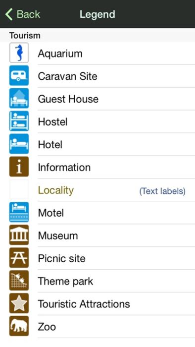
- 3D labels/icons of Points of Interest (POIs)
- Integrated Wikipedia descriptions
- Place searching by name (Online and Offline)
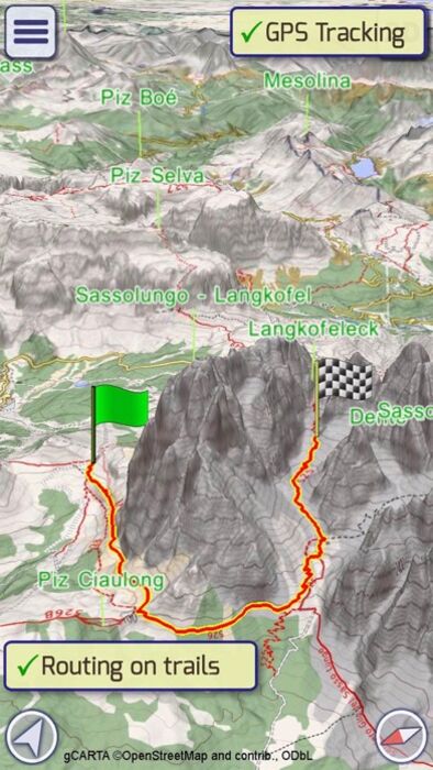
- GPS tracking
- Routing
- Personal Points of Interest (POIs)
- Sync of tracks and routes on all your devices (iCloud)
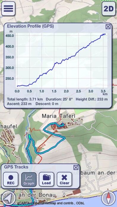
- Altimetry graph and statistics
- Custom-made gCARTA topographic chart
- Gyroscope features: GyroPilot and First Person View (Immersive Reality)
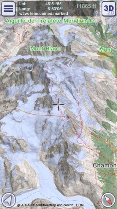
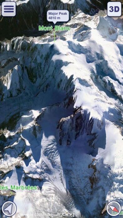
GeoFlyer 3D Maps Europe reproduces the terrain in 3D with stunning details, using the best available digital elevation models from NASA and various European mapping agencies.
The terrain is overlaid with a custom-made topographic chart (gCARTA) that shows trails and accurate elevation contour lines, or aerial images if you prefer.
Find out more about a POI using the labels and icons. Wikipedia geo-tagged entries and other associated content are integrated right into the 3D map.
Plan your trip using multiple routing options, and save your routes for later use.
Record your GPS tracks and share them with your friends through Facebook or other social media.
Get the best from your outdoor experience with the “First Person View” mode, a sort of augmented reality feature that enables you to see a virtual 3D view of what is in front of you, allowing you to identify peaks and other landmarks.
And it’s fun! Try the GyroPilot mode: dive into the valleys with a low level flyby, handling your device like a virtual plane, and explore the maps like a top-gun pilot!
GeoFlyer 3D Maps… your outdoor companion!
WARNING
Continued use of GPS running in the background can dramatically decrease battery life.
更新履歴
* Added Hiking Mode to the Routing tool
* Improved the iCloud synchronization of tracks
* Improved the height graph of GPS tracks
How would you like a mapping app that shows points of interest in 3D with info or links to embedded Wikipedia pages?
How would you like a mapping app that works OFFLINE, too?
GeoFlyer 3D Maps offers you all this and more!
If you love hiking, biking, horseback riding, or any other outdoor activity, GeoFlyer 3D Maps is the app you need.
MAIN FEATURES
- Online and Offline modes (with preloading of selected areas)
- Highly-detailed 3D terrain
- 3D labels/icons of Points of Interest (POIs)
- Integrated Wikipedia descriptions
- Place searching by name (Online and Offline)
- GPS tracking
- Routing
- Personal Points of Interest (POIs)
- Sync of tracks and routes on all your devices (iCloud)
- Altimetry graph and statistics
- Custom-made gCARTA topographic chart
- Gyroscope features: GyroPilot and First Person View (Immersive Reality)
GeoFlyer 3D Maps Europe reproduces the terrain in 3D with stunning details, using the best available digital elevation models from NASA and various European mapping agencies.
The terrain is overlaid with a custom-made topographic chart (gCARTA) that shows trails and accurate elevation contour lines, or aerial images if you prefer.
Find out more about a POI using the labels and icons. Wikipedia geo-tagged entries and other associated content are integrated right into the 3D map.
Plan your trip using multiple routing options, and save your routes for later use.
Record your GPS tracks and share them with your friends through Facebook or other social media.
Get the best from your outdoor experience with the “First Person View” mode, a sort of augmented reality feature that enables you to see a virtual 3D view of what is in front of you, allowing you to identify peaks and other landmarks.
And it’s fun! Try the GyroPilot mode: dive into the valleys with a low level flyby, handling your device like a virtual plane, and explore the maps like a top-gun pilot!
GeoFlyer 3D Maps… your outdoor companion!
WARNING
Continued use of GPS running in the background can dramatically decrease battery life.
更新履歴
* Added Hiking Mode to the Routing tool
* Improved the iCloud synchronization of tracks
* Improved the height graph of GPS tracks
ブログパーツ第二弾を公開しました!ホームページでアプリの順位・価格・周辺ランキングをご紹介頂けます。
ブログパーツ第2弾!
アプリの周辺ランキングを表示するブログパーツです。価格・順位共に自動で最新情報に更新されるのでアプリの状態チェックにも最適です。
ランキング圏外の場合でも周辺ランキングの代わりに説明文を表示にするので安心です。
サンプルが気に入りましたら、下に表示されたHTMLタグをそのままページに貼り付けることでご利用頂けます。ただし、一般公開されているページでご使用頂かないと表示されませんのでご注意ください。
幅200px版
幅320px版
お気に入りのアプリをご紹介頂くためのブログパーツです。アプリの価格や順位表示は毎日自動更新♪
サンプルが気に入りましたら、下に表示されたHTMLタグをそのままページに貼り付けることでご利用頂けます。
※配信を停止させていただく可能性もございますので、タグの改変はご遠慮ください。

Now Loading...

「iPhone & iPad アプリランキング」は、最新かつ詳細なアプリ情報をご紹介しているサイトです。
お探しのアプリに出会えるように様々な切り口でページをご用意しております。
「メニュー」よりぜひアプリ探しにお役立て下さい。
Presents by $$308413110 スマホからのアクセスにはQRコードをご活用ください。 →
Now loading...