ForumApp |
| この情報はストアのものより古い可能性がございます。 | ||||


|
価格 | 無料 | ダウンロード |
|
|---|---|---|---|---|
| ジャンル | 旅行 | |||
サイズ | 96.7MB | |||
| 開発者 | Mondadori Electa S.p.A. | |||
| 順位 |
| |||
| リリース日 | 2014-09-16 16:00:00 | 評価 | 評価が取得できませんでした。 | |
| 互換性 | iOS 7.0以降が必要です。 iPhone、iPad および iPod touch 対応。 | |||
(see below for app description in English)
[ITALIANO]
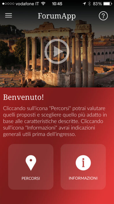
La Soprintendenza per i Beni Archeologici di Roma, in collaborazione con Electa, presenta Forum App, la mappa interattiva per visitare il Foro Romano e il colle Palatino: il cuore di un impero che per secoli ha dominato il mondo e ne ha plasmato la storia.
E’ lo strumento indispensabile che aiuta a orientarsi in tutta l’area e a individuare sempre i servizi disponibili, inoltre fornisce le informazioni di base sui principali monumenti.
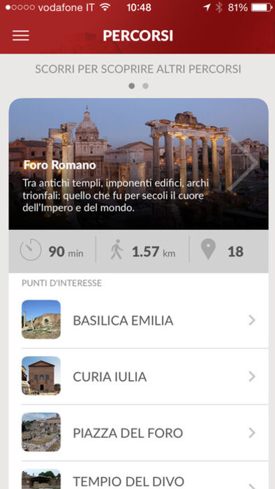
Potrai scegliere tra i percorsi proposti, i monumenti da vedere sono segnalati da icone e quando sarai in prossimità di uno di questi sarai avvisato da un segnale sonoro. I monumenti sono descritti con foto e testi che potrai leggere o ascoltare cliccando sull'apposito tasto. La tua posizione verrà sempre segnalata sulla mappa da un puntino luminoso.
Con un semplice comando potrai sempre decidere di visualizzare sulla mappa anche i servizi disponibili come: fontanelle d’acqua, toilette, punti di raccolta, percorsi accessibili e uscite/entrate.
L'uso continuato del GPS in background può causare una drammatica riduzione della durata della batteria.
[ENGLISH]
Soprintendenza Speciale per i Beni Archeologici di Roma, in partnership with Electa, presents Forum App, the interactive map for visiting the Roman Forum and the Palatine Hill: the heart of an empire that dominated the world for centuries and shaped its history.
This must-have tool helps you get your bearings in the entire area and will always trace available services, as well as providing basic information about main monuments.
Choose from suggested routes, monuments worth seeing are indicated with icons, and when you’re near one of these you’ll be alerted by a beep. The monuments are described by entries complete with photos and text that you can read or listen to by clicking on the specific button. Your position will always be indicated on the map by a bright dot.
With a simple command you can also display on the map the position of facilities like water fountains, toilets, assembly points, accessible paths, entrances and exits.
Continued use of GPS running in the background can dramatically decrease battery life.
更新履歴
ottimizzazione dei contenuti
bug fixing
[ITALIANO]
La Soprintendenza per i Beni Archeologici di Roma, in collaborazione con Electa, presenta Forum App, la mappa interattiva per visitare il Foro Romano e il colle Palatino: il cuore di un impero che per secoli ha dominato il mondo e ne ha plasmato la storia.
E’ lo strumento indispensabile che aiuta a orientarsi in tutta l’area e a individuare sempre i servizi disponibili, inoltre fornisce le informazioni di base sui principali monumenti.
Potrai scegliere tra i percorsi proposti, i monumenti da vedere sono segnalati da icone e quando sarai in prossimità di uno di questi sarai avvisato da un segnale sonoro. I monumenti sono descritti con foto e testi che potrai leggere o ascoltare cliccando sull'apposito tasto. La tua posizione verrà sempre segnalata sulla mappa da un puntino luminoso.
Con un semplice comando potrai sempre decidere di visualizzare sulla mappa anche i servizi disponibili come: fontanelle d’acqua, toilette, punti di raccolta, percorsi accessibili e uscite/entrate.
L'uso continuato del GPS in background può causare una drammatica riduzione della durata della batteria.
[ENGLISH]
Soprintendenza Speciale per i Beni Archeologici di Roma, in partnership with Electa, presents Forum App, the interactive map for visiting the Roman Forum and the Palatine Hill: the heart of an empire that dominated the world for centuries and shaped its history.
This must-have tool helps you get your bearings in the entire area and will always trace available services, as well as providing basic information about main monuments.
Choose from suggested routes, monuments worth seeing are indicated with icons, and when you’re near one of these you’ll be alerted by a beep. The monuments are described by entries complete with photos and text that you can read or listen to by clicking on the specific button. Your position will always be indicated on the map by a bright dot.
With a simple command you can also display on the map the position of facilities like water fountains, toilets, assembly points, accessible paths, entrances and exits.
Continued use of GPS running in the background can dramatically decrease battery life.
更新履歴
ottimizzazione dei contenuti
bug fixing
ブログパーツ第二弾を公開しました!ホームページでアプリの順位・価格・周辺ランキングをご紹介頂けます。
ブログパーツ第2弾!
アプリの周辺ランキングを表示するブログパーツです。価格・順位共に自動で最新情報に更新されるのでアプリの状態チェックにも最適です。
ランキング圏外の場合でも周辺ランキングの代わりに説明文を表示にするので安心です。
サンプルが気に入りましたら、下に表示されたHTMLタグをそのままページに貼り付けることでご利用頂けます。ただし、一般公開されているページでご使用頂かないと表示されませんのでご注意ください。
幅200px版
幅320px版
お気に入りのアプリをご紹介頂くためのブログパーツです。アプリの価格や順位表示は毎日自動更新♪
サンプルが気に入りましたら、下に表示されたHTMLタグをそのままページに貼り付けることでご利用頂けます。
※配信を停止させていただく可能性もございますので、タグの改変はご遠慮ください。

Now Loading...

「iPhone & iPad アプリランキング」は、最新かつ詳細なアプリ情報をご紹介しているサイトです。
お探しのアプリに出会えるように様々な切り口でページをご用意しております。
「メニュー」よりぜひアプリ探しにお役立て下さい。
Presents by $$308413110 スマホからのアクセスにはQRコードをご活用ください。 →
Now loading...