Cruise Ports -Europe Zoomable Atlas |
| この情報はストアのものより古い可能性がございます。 | ||||
|
価格 | 250円 | ダウンロード |
|
|---|---|---|---|---|
| ジャンル | 旅行 | |||
サイズ | 15.6MB | |||
| 開発者 | Henry Vaughan | |||
| 順位 |
| |||
| リリース日 | 2014-05-09 06:25:34 | 評価 | 評価が取得できませんでした。 | |
| 互換性 | iOS 7.1以降が必要です。 iPhone、iPad および iPod touch 対応。 | |||
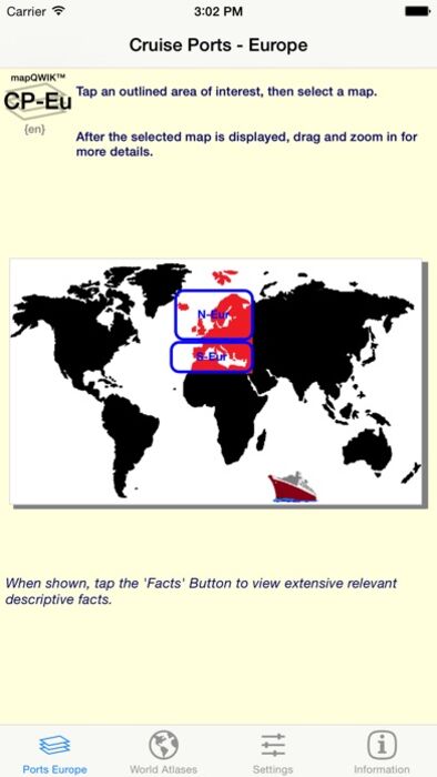
Our zoomable 'Cruise Ports -Europe' map atlas is a specialized product that covers popular saltwater cruise ship ports in 'Europe' (from Reykjavík in Iceland to Port Said in northern Egypt) and is available in the languages of English [the Default], Spanish, French, German, Italian, Netherlands [Dutch], Portuguese (Europe), and Portuguese (Brazil). It generates a series of custom real-time regional maps showing colored markers where popular cruise ports (and related destinations) are located. Also included are maps and facts for each of these ports [red & orange markers] and for related slow-cruising locations [blue markers] and nearby popular land destinations [yellow markers].
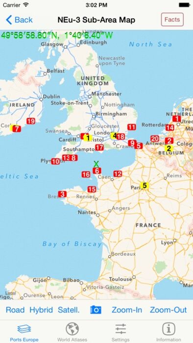
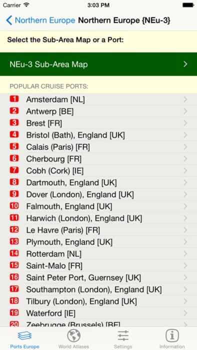
Using the 'Ports Europe' tab, select the region of general interest by tapping the desired area on the red map of 'Europe'. Choose a sub-area of interest. A list of available numbered destinations in that selected region will then be displayed, as well as a button to display an overview map of the selected area showing colored markers at the locations of all of the popular destinations in that area. Tap the name of the desired destination in the list to display a detail map of that destination.
If you give permission in the Privacy Settings of your device, this version will also show your current location on the maps as a pulsating blue circular marker. If you adjust the map being displayed, your current location will be automatically updated using your device's GPS location.
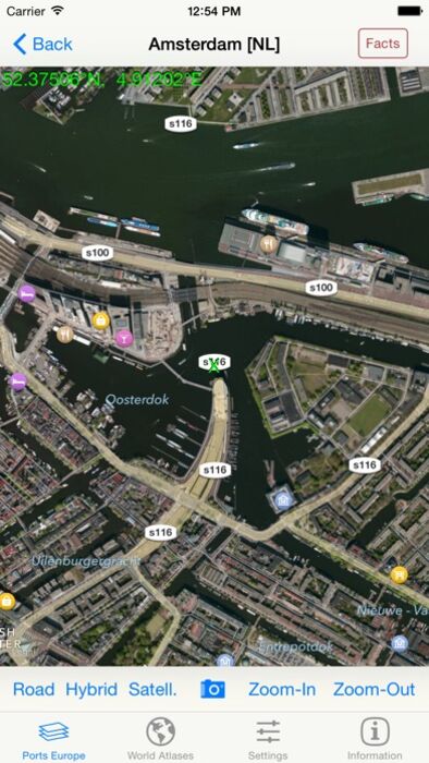
Easily switch between 'Road', 'Hybrid', or 'Satellite' maps, and zoom in (and out) to any detail level desired -- down to the house level! Change to a different area of focus with the drag of a finger and your display is instantly updated.
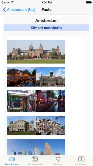
Tapping a 'Facts' Button, when shown, displays extensive relevant interactive descriptive information from Wikipedia. By following indicated links, more facts and photos are available in a specific areas of interest.
Using a new 'Settings' tab, you can select the GPS Coordinates format to be displayed on all maps, or omit it. Three different popular display formats are supported: Traditional [dddmmss.xx] , Modern [ddd.xxxxx], and Geocaching [dddmm.xxx]. As you drag or zoom on a map display, the GPS coordinates of the center of the display are automatically updated.
Tap the camera icon to quickly capture the created map image to your device's Photo Gallery. [Later you can print or share this image with others via Facebook, Twitter, Flickr, or email using the Apple-provided 'Photo' app.]
Using the 'World' tab, tap an appropriate button to launch any of the other component apps in our World Atlas series that are installed on the device.
更新履歴
revised and added new app links per revised iOS specs; if you grant permission, adds new current location marker on maps; minor bug and performance fixes;
Using the 'Ports Europe' tab, select the region of general interest by tapping the desired area on the red map of 'Europe'. Choose a sub-area of interest. A list of available numbered destinations in that selected region will then be displayed, as well as a button to display an overview map of the selected area showing colored markers at the locations of all of the popular destinations in that area. Tap the name of the desired destination in the list to display a detail map of that destination.
If you give permission in the Privacy Settings of your device, this version will also show your current location on the maps as a pulsating blue circular marker. If you adjust the map being displayed, your current location will be automatically updated using your device's GPS location.
Easily switch between 'Road', 'Hybrid', or 'Satellite' maps, and zoom in (and out) to any detail level desired -- down to the house level! Change to a different area of focus with the drag of a finger and your display is instantly updated.
Tapping a 'Facts' Button, when shown, displays extensive relevant interactive descriptive information from Wikipedia. By following indicated links, more facts and photos are available in a specific areas of interest.
Using a new 'Settings' tab, you can select the GPS Coordinates format to be displayed on all maps, or omit it. Three different popular display formats are supported: Traditional [dddmmss.xx] , Modern [ddd.xxxxx], and Geocaching [dddmm.xxx]. As you drag or zoom on a map display, the GPS coordinates of the center of the display are automatically updated.
Tap the camera icon to quickly capture the created map image to your device's Photo Gallery. [Later you can print or share this image with others via Facebook, Twitter, Flickr, or email using the Apple-provided 'Photo' app.]
Using the 'World' tab, tap an appropriate button to launch any of the other component apps in our World Atlas series that are installed on the device.
更新履歴
revised and added new app links per revised iOS specs; if you grant permission, adds new current location marker on maps; minor bug and performance fixes;
ブログパーツ第二弾を公開しました!ホームページでアプリの順位・価格・周辺ランキングをご紹介頂けます。
ブログパーツ第2弾!
アプリの周辺ランキングを表示するブログパーツです。価格・順位共に自動で最新情報に更新されるのでアプリの状態チェックにも最適です。
ランキング圏外の場合でも周辺ランキングの代わりに説明文を表示にするので安心です。
サンプルが気に入りましたら、下に表示されたHTMLタグをそのままページに貼り付けることでご利用頂けます。ただし、一般公開されているページでご使用頂かないと表示されませんのでご注意ください。
幅200px版
幅320px版
お気に入りのアプリをご紹介頂くためのブログパーツです。アプリの価格や順位表示は毎日自動更新♪
サンプルが気に入りましたら、下に表示されたHTMLタグをそのままページに貼り付けることでご利用頂けます。
※配信を停止させていただく可能性もございますので、タグの改変はご遠慮ください。

Now Loading...

「iPhone & iPad アプリランキング」は、最新かつ詳細なアプリ情報をご紹介しているサイトです。
お探しのアプリに出会えるように様々な切り口でページをご用意しております。
「メニュー」よりぜひアプリ探しにお役立て下さい。
Presents by $$308413110 スマホからのアクセスにはQRコードをご活用ください。 →
Now loading...