The Photographer's Transit |
| この情報はストアのものより古い可能性がございます。 | ||||
|
価格 | 1300円 | ダウンロード |
|
|---|---|---|---|---|
| ジャンル | 写真/ビデオ | |||
サイズ | 73.7MB | |||
| 開発者 | Crookneck Consulting LLC | |||
| 順位 |
| |||
| リリース日 | 2013-09-02 16:00:00 | 評価 |
|
|
| 互換性 | iOS 10.0以降が必要です。 iPhone、iPad および iPod touch 対応。 | |||
 (2人)
(2人)
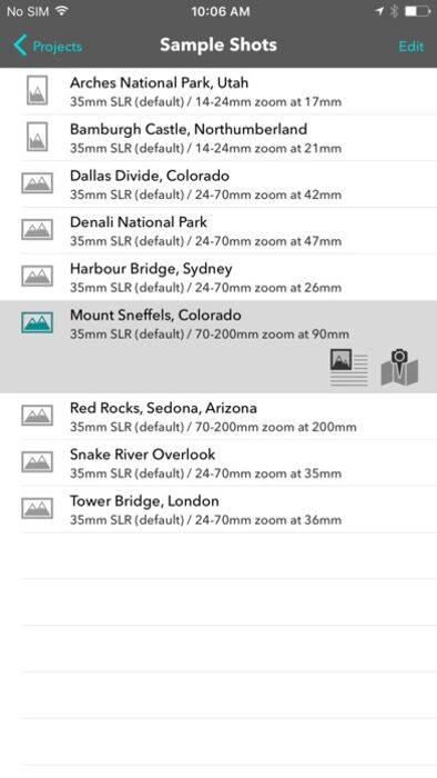
Visual field-of-view calculator and shot planner for outdoor photographers.
The Photographer's Transit ("Photo Transit") is a map-based shot planning tool for outdoor photographers who use interchangeable lens cameras (such as SLRs). Plan the best possible camera, lenses and shooting locations for your photo trip or assignment using the sophisticated built-in field of view simulator.
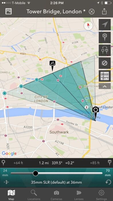
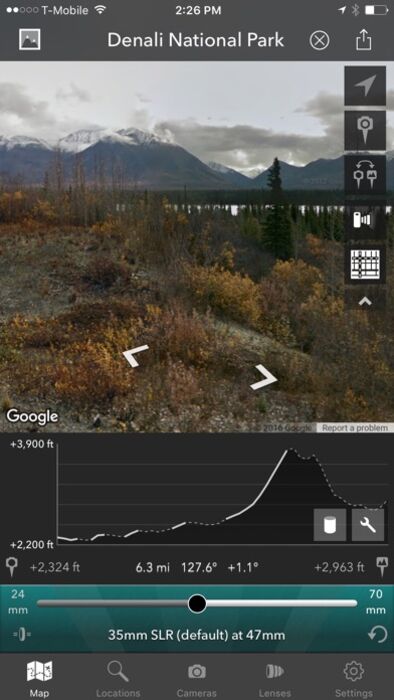
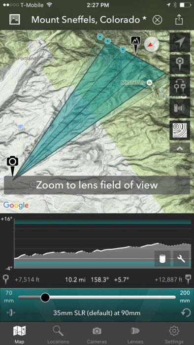
Photo Transit includes detailed elevation profile information so you can scout your sightlines ahead of time, and check whether your planned focal length will capture your subject. Photo Transit's vertical field of view chart lets you see if your subject will be visible or obstructed by the local terrain.
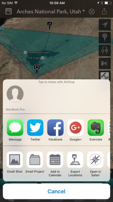
Create projects containing detailed shot lists, including camera and subject location, height above the ground, pitch, orientation and focal length. Share your planned shots with colleagues and friends via email and social media, or export them as KML for use in your favourite GPS app.
With a rich feature set including Google Street View, and offline maps and elevation data, and a choice of elevation data sources, The Photographer's Transit is a powerful tool for any photographer who likes to be well prepared.
Key features:
- Define your own camera and lens kits
- 5 available map types, including 2 offline map choices
- Adjustable field of view map overlay
- Google Street View camera control
- Elevation profile from camera to subject location
- Apparent altitude profile to visualize the effect of local terrain
- Find and save your favorite locations
- Shot lists and projects
- Integrates with TPE (The Photographer's Ephemeris)
- Sample project with example shots and reference photos
Sharing + Export:
- Twitter, Facebook, Message
- View in Safari
- Email Shot
- Email Project
- Add shot to calendar
- Import/export locations
- All sharing options include link to website so you can freely share your photo plans with friends and colleagues
Advanced features:
- Teleconverter support
- Add custom sensor/film type
- Show field of view for multiple prime lenses
- Simulate lens zoom directly
- Camera-subject distance, bearing, altitude
- Camera orientation, pitch and height above ground
- Subject height above ground
- Map tilt and rotate, autorotate
- Magnetic north option
- Multiple elevation data sources available (Google, SRTM1, SRTM3, AsterGDEM, GTOPO30)
- SRTM1, SRTM3, AsterGDEM and GTOPO30 elevation data is saved for offline use
- KML project and shot export
Available map types include:
- Google Maps Standard, Hybrid, Terrain
- OpenCycleMap Topographic (available offline)
- OpenStreetMap (available offline)
Note:
- This app is designed for photographers using interchangeable lens cameras (e.g. SLR, Micro 4/3rds, Medium/Large format film)
- Maps and elevation-based calculations require a data connection unless an offline data source is used
- Maps and elevation data must be viewed while connected to the internet in order to be saved for later use offline
- Not all map types and elevation data sources are available offline
- Topographic map data is available only between 60°N and 47°S
- Overlay maps are not always available for the highest zoom levels
- Topographic maps courtesy of OpenCycleMap.org
- OSM map tiles courtesy of CartoDB
- Google Elevation data is subject to daily usage limits per IP address
- Availability of specific map types and Google Street View is dependent on 3rd party map service availability, terms and conditions, and is subject to change
- Google Maps, Google Street View and Google Earth are trademarks owned by Google Inc.
- Future updates may require iOS 9 or higher
Plan the perfect vantage point for your photographic subjects and enjoy a better field of view!
更新履歴
- Fixes errors on location search
- Updated SDKs and libraries
The Photographer's Transit ("Photo Transit") is a map-based shot planning tool for outdoor photographers who use interchangeable lens cameras (such as SLRs). Plan the best possible camera, lenses and shooting locations for your photo trip or assignment using the sophisticated built-in field of view simulator.
Photo Transit includes detailed elevation profile information so you can scout your sightlines ahead of time, and check whether your planned focal length will capture your subject. Photo Transit's vertical field of view chart lets you see if your subject will be visible or obstructed by the local terrain.
Create projects containing detailed shot lists, including camera and subject location, height above the ground, pitch, orientation and focal length. Share your planned shots with colleagues and friends via email and social media, or export them as KML for use in your favourite GPS app.
With a rich feature set including Google Street View, and offline maps and elevation data, and a choice of elevation data sources, The Photographer's Transit is a powerful tool for any photographer who likes to be well prepared.
Key features:
- Define your own camera and lens kits
- 5 available map types, including 2 offline map choices
- Adjustable field of view map overlay
- Google Street View camera control
- Elevation profile from camera to subject location
- Apparent altitude profile to visualize the effect of local terrain
- Find and save your favorite locations
- Shot lists and projects
- Integrates with TPE (The Photographer's Ephemeris)
- Sample project with example shots and reference photos
Sharing + Export:
- Twitter, Facebook, Message
- View in Safari
- Email Shot
- Email Project
- Add shot to calendar
- Import/export locations
- All sharing options include link to website so you can freely share your photo plans with friends and colleagues
Advanced features:
- Teleconverter support
- Add custom sensor/film type
- Show field of view for multiple prime lenses
- Simulate lens zoom directly
- Camera-subject distance, bearing, altitude
- Camera orientation, pitch and height above ground
- Subject height above ground
- Map tilt and rotate, autorotate
- Magnetic north option
- Multiple elevation data sources available (Google, SRTM1, SRTM3, AsterGDEM, GTOPO30)
- SRTM1, SRTM3, AsterGDEM and GTOPO30 elevation data is saved for offline use
- KML project and shot export
Available map types include:
- Google Maps Standard, Hybrid, Terrain
- OpenCycleMap Topographic (available offline)
- OpenStreetMap (available offline)
Note:
- This app is designed for photographers using interchangeable lens cameras (e.g. SLR, Micro 4/3rds, Medium/Large format film)
- Maps and elevation-based calculations require a data connection unless an offline data source is used
- Maps and elevation data must be viewed while connected to the internet in order to be saved for later use offline
- Not all map types and elevation data sources are available offline
- Topographic map data is available only between 60°N and 47°S
- Overlay maps are not always available for the highest zoom levels
- Topographic maps courtesy of OpenCycleMap.org
- OSM map tiles courtesy of CartoDB
- Google Elevation data is subject to daily usage limits per IP address
- Availability of specific map types and Google Street View is dependent on 3rd party map service availability, terms and conditions, and is subject to change
- Google Maps, Google Street View and Google Earth are trademarks owned by Google Inc.
- Future updates may require iOS 9 or higher
Plan the perfect vantage point for your photographic subjects and enjoy a better field of view!
更新履歴
- Fixes errors on location search
- Updated SDKs and libraries
ブログパーツ第二弾を公開しました!ホームページでアプリの順位・価格・周辺ランキングをご紹介頂けます。
ブログパーツ第2弾!
アプリの周辺ランキングを表示するブログパーツです。価格・順位共に自動で最新情報に更新されるのでアプリの状態チェックにも最適です。
ランキング圏外の場合でも周辺ランキングの代わりに説明文を表示にするので安心です。
サンプルが気に入りましたら、下に表示されたHTMLタグをそのままページに貼り付けることでご利用頂けます。ただし、一般公開されているページでご使用頂かないと表示されませんのでご注意ください。
幅200px版
幅320px版
お気に入りのアプリをご紹介頂くためのブログパーツです。アプリの価格や順位表示は毎日自動更新♪
サンプルが気に入りましたら、下に表示されたHTMLタグをそのままページに貼り付けることでご利用頂けます。
※配信を停止させていただく可能性もございますので、タグの改変はご遠慮ください。

Now Loading...

「iPhone & iPad アプリランキング」は、最新かつ詳細なアプリ情報をご紹介しているサイトです。
お探しのアプリに出会えるように様々な切り口でページをご用意しております。
「メニュー」よりぜひアプリ探しにお役立て下さい。
Presents by $$308413110 スマホからのアクセスにはQRコードをご活用ください。 →
Now loading...