GPX viewer 2 |

|
価格 | 無料 | ダウンロード |
|
|---|---|---|---|---|
| ジャンル | ナビゲーション | |||
サイズ | 3.9MB | |||
| 開発者 | Jonathan Gander | |||
| 順位 |
| |||
| リリース日 | 2023-01-04 17:00:00 | 評価 |
|
|
| 互換性 | iOS 16.0以降が必要です。 iPhone、iPad および iPod touch 対応。 | |||
 (1人)
(1人)
GPX viewer 2 is the brand new version of my first GPX viewer app! With new features, a new modern user interface and new interactions. I've listened to your needs and built a new app just for you!
Import your tracks from GPX files (tracks or routes) into the app. Even if your file contains many tracks.
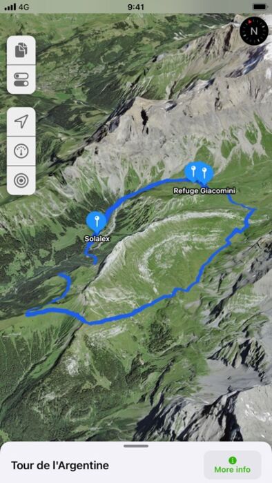
Display their tracks on different preset base maps (plan, satellite, OpenStreetMap, OpenTopoMap, Swisstopo, IGN) or on any of your own custom base maps.
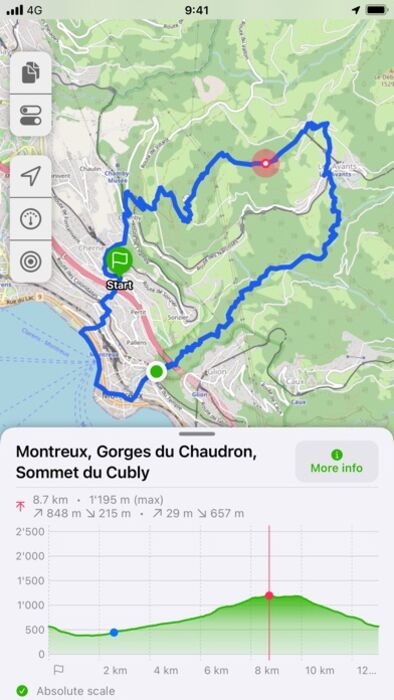
Display an interactive elevation profile to evaluate track difficulty. And check out all of information contained into your GPX file (such as description, images, links, waypoints and stats).
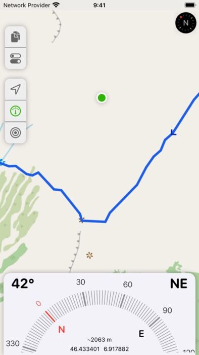
Track your position along the route during your hike by following the path on the interactive map. You can also view GPX points of interest, navigation tools (compass, GPS location, altitude) and a speedometer. The app even provides weather conditions at the starting point of your itinerary.
All what you need to go hiking and follow your route... without ads! The only in-app purchases are tips for few other features, just take a look.
GPX viewer is the app you need for your hikes and bike or motorcycle trips!
Features details:
- Import of GPX files via file, web link or from your Fitness app
- Management of imported GPX (library)
- Display GPX track on the map (track and route, also support multi-tracks)
- Several base maps: map, hybrid, satellite 3D, OpenStreetMap, OpenTopoMap, Swisstopo
- Possibility to set your own custom maps from a library or manually
- Possibility to download maps for offline use
- Displayed on the map: current position, start and end of the route, points of interest along the route, scale, route direction
- Choice of color and size of the route
- Locking of screen standby to better follow the route
- Map cache system
- Display of GPX details: name, description, elevation profile, elevation differences, distance, altitudes, image gallery, link, points of interest
- Display details of a point of interest: name, description, image gallery, links, distance on the track
- Navigation tools: compass, GPS location, altitude
- Weather condition at starting point
- Access to the route via Maps, Google Maps or Waze
- Sharing a GPX
- GPX editor
- Speedometer
Note: Hey! If you can't open a file from my app, please contact me and provide me the file, I will take a look.
What about GPX viewer 1? The app is still available on the App Store if your device is not compatible with GPX viewer 2.
更新履歴
- New: You can now choose between 4 coordinates formats (thanks Patrick!)
Import your tracks from GPX files (tracks or routes) into the app. Even if your file contains many tracks.
Display their tracks on different preset base maps (plan, satellite, OpenStreetMap, OpenTopoMap, Swisstopo, IGN) or on any of your own custom base maps.
Display an interactive elevation profile to evaluate track difficulty. And check out all of information contained into your GPX file (such as description, images, links, waypoints and stats).
Track your position along the route during your hike by following the path on the interactive map. You can also view GPX points of interest, navigation tools (compass, GPS location, altitude) and a speedometer. The app even provides weather conditions at the starting point of your itinerary.
All what you need to go hiking and follow your route... without ads! The only in-app purchases are tips for few other features, just take a look.
GPX viewer is the app you need for your hikes and bike or motorcycle trips!
Features details:
- Import of GPX files via file, web link or from your Fitness app
- Management of imported GPX (library)
- Display GPX track on the map (track and route, also support multi-tracks)
- Several base maps: map, hybrid, satellite 3D, OpenStreetMap, OpenTopoMap, Swisstopo
- Possibility to set your own custom maps from a library or manually
- Possibility to download maps for offline use
- Displayed on the map: current position, start and end of the route, points of interest along the route, scale, route direction
- Choice of color and size of the route
- Locking of screen standby to better follow the route
- Map cache system
- Display of GPX details: name, description, elevation profile, elevation differences, distance, altitudes, image gallery, link, points of interest
- Display details of a point of interest: name, description, image gallery, links, distance on the track
- Navigation tools: compass, GPS location, altitude
- Weather condition at starting point
- Access to the route via Maps, Google Maps or Waze
- Sharing a GPX
- GPX editor
- Speedometer
Note: Hey! If you can't open a file from my app, please contact me and provide me the file, I will take a look.
What about GPX viewer 1? The app is still available on the App Store if your device is not compatible with GPX viewer 2.
更新履歴
- New: You can now choose between 4 coordinates formats (thanks Patrick!)
ブログパーツ第二弾を公開しました!ホームページでアプリの順位・価格・周辺ランキングをご紹介頂けます。
ブログパーツ第2弾!
アプリの周辺ランキングを表示するブログパーツです。価格・順位共に自動で最新情報に更新されるのでアプリの状態チェックにも最適です。
ランキング圏外の場合でも周辺ランキングの代わりに説明文を表示にするので安心です。
サンプルが気に入りましたら、下に表示されたHTMLタグをそのままページに貼り付けることでご利用頂けます。ただし、一般公開されているページでご使用頂かないと表示されませんのでご注意ください。
幅200px版
幅320px版
お気に入りのアプリをご紹介頂くためのブログパーツです。アプリの価格や順位表示は毎日自動更新♪
サンプルが気に入りましたら、下に表示されたHTMLタグをそのままページに貼り付けることでご利用頂けます。
※配信を停止させていただく可能性もございますので、タグの改変はご遠慮ください。

Now Loading...

「iPhone & iPad アプリランキング」は、最新かつ詳細なアプリ情報をご紹介しているサイトです。
お探しのアプリに出会えるように様々な切り口でページをご用意しております。
「メニュー」よりぜひアプリ探しにお役立て下さい。
Presents by $$308413110 スマホからのアクセスにはQRコードをご活用ください。 →
Now loading...