Nobeltec Marine Navigation |
| この情報はストアのものより古い可能性がございます。 | ||||
| 価格 | 無料 | ダウンロード |
||
|---|---|---|---|---|
| ジャンル | ナビゲーション | |||
サイズ | 260.0MB (ダウンロードにWIFIが必要) | |||
| 開発者 | MaxSea International | |||
| 順位 |
| |||
| リリース日 | 2013-06-13 00:04:35 | 評価 | 評価が取得できませんでした。 | |
| 互換性 | iOS 8.0以降が必要です。 iPad 対応。 | |||
"Picking routes, waypoints, and marks on the TZ screen always seem easy and I always seem to find whatever option I might need." Ben Ellison, Panbo.com
"If you're a basic coastal cruiser this app will be a great addition to your Marine navigation tool box." Mark Messerli, i-marineapps.blogspot.com
Nobeltec TimeZero is the ultimate App for marine navigation. More than 95.000 customers around the world already trust TimeZero!
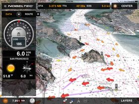
Nobeltec TimeZero is a marine navigation App specially designed for coastal sailors with the most cutting-edge and useful tools & data needed.
Thanks to the outstanding TimeZero technology and PhotoFusion feature, Nobeltec’s marine chart App has a powerful 3D chart engine allowing you to scroll, zoom and rotate the MapMedia Raster charts in no time.
ROBUST TECHNOLOGY & DATA
• 2D/3D chart display engine
• Complete navigation functions in full 2D/3D
• Patented PhotoFusion technology
• MapMedia Raster mm3d charts
BASIC FEATURES
• Your position on the chart
• Course (COG)
• Speed (SOG)
• Real-time weather and weather trends
• Tides and tidal currents
WHAT’S INSIDE?
• Plot your position in real-time on the most accurate Raster marine charts thanks to the built-in geolocation features of your iPad (GPS and/or WiFi);
• Easily create waypoints and routes;
• Keep as many as 50 routes and display them easily at any time;
• Overlay complete tidal information (tide heights and tidal currents) directly on the chart;
• Thanks to PhotoFusion, overlay satellite photos for a perfect understanding of the coast line;
• Enjoy native compatibility with the FURUNO 1st Watch Wireless Radar (DRS4W) for radar overlay directly across your App's chart - Radar Module required;
• View AIS targets directly on your App's chart in real-time - AIS Module required;
• Configure your NavData panel to keep on screen the specific instrument readings that are most useful to you: COG, SOG, Pos, Accu., CTS, NEXT, TTG, DTW, XTE, VMC, ETA, TTA, DTA, Weather;
• Navigate instantly to a waypoint (Go-To tool);
• Choose the chart orientation (Course-Up or North-Up), go back instantly to your vessel (Center On vessel) and switch from 2D to a 3D full view in just one click;
• Undo/Redo feature, don’t worry about doing mistakes;
• Share your position and comments on Facebook.
The ultimate App for marine navigation.
Important Notice: Continued use of GPS running in the background can dramatically decrease battery life.
更新履歴
Various bug fixes.
Cloud backup and restore of user data.
ブログパーツ第二弾を公開しました!ホームページでアプリの順位・価格・周辺ランキングをご紹介頂けます。
ブログパーツ第2弾!
アプリの周辺ランキングを表示するブログパーツです。価格・順位共に自動で最新情報に更新されるのでアプリの状態チェックにも最適です。
ランキング圏外の場合でも周辺ランキングの代わりに説明文を表示にするので安心です。
サンプルが気に入りましたら、下に表示されたHTMLタグをそのままページに貼り付けることでご利用頂けます。ただし、一般公開されているページでご使用頂かないと表示されませんのでご注意ください。
幅200px版
幅320px版
Now Loading...

「iPhone & iPad アプリランキング」は、最新かつ詳細なアプリ情報をご紹介しているサイトです。
お探しのアプリに出会えるように様々な切り口でページをご用意しております。
「メニュー」よりぜひアプリ探しにお役立て下さい。
Presents by $$308413110 スマホからのアクセスにはQRコードをご活用ください。 →
Now loading...


