i-Boating:Oman,Arabian/Persian Gulf & Red Sea Maps |
| このアプリは現在ストアで閲覧することができません。 | ||||


|
価格 | 3680円 | ダウンロード |
|
|---|---|---|---|---|
| ジャンル | ナビゲーション | |||
サイズ | 49.9MB | |||
| 開発者 | Bist LLC | |||
| 順位 |
| |||
| リリース日 | 2013-03-06 10:58:47 | 評価 | 評価が取得できませんでした。 | |
| 互換性 | iOS 7.0以降が必要です。 iPhone、iPad および iPod touch 対応。 | |||
|
||||
GPS Marine Charts App offers access to charts covering Oman. Only marine GPS app to have route assistance with Voice Prompts for marine navigation. It has route manager to create new boating routes or import existing GPX/KML routes. It supports Nautical Charts course up orientation.
* Voice Prompts for marine navigation (requires GPS )
-prompts when approaching a boating route marker
-Continous distance and ETA updates
-Alerts when sailing/boating off route
-Alerts when boating in wrong direction
*** For any question, contact support at gpsnauticalcharts.com / http://www.gpsnauticalcharts.com ***
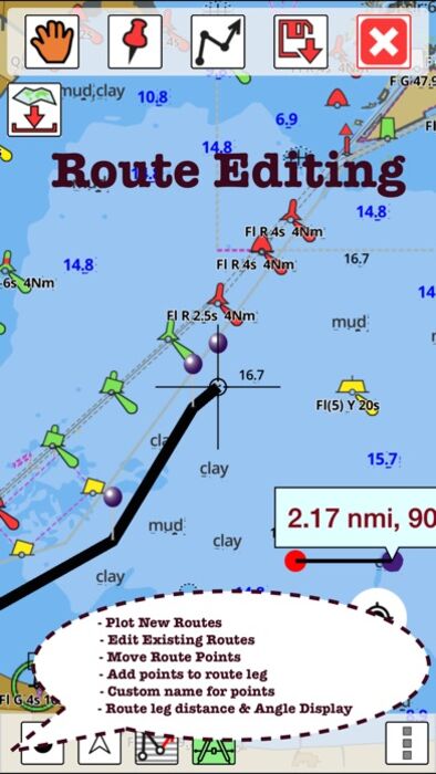
*Route Editing/Creation
-Create routes from scratch
-Edit existing GPX/KML routes.
-Add custom description to any route point.
-Drop markers along route.
* Offline Oman charts.
-Visually draw area to download
-Textual search
-Catalog
-Charts reprojected for WGS84 datum
*Seamless chart quilting of marine charts
*Distance Bearing tool
*Create custom way points
- Using GPS
-Select point on map
-Manually enter latitude & longitude coordinates
*POI layer for marine charts
- Overlay POIs
- POI list derived from the equivalent ENC and contains all categories including Buoy, Light, Harbour facility, Obstr.
*Search POIs/Way points
*Pan/Zoom/My Location
* Record Marine GPS tracks
* View tracks overlay
* Live track animation
* Track analytics/stats
* Export GPX tracks.
-Export to SDCard
-Share GPX trakcs with friends.
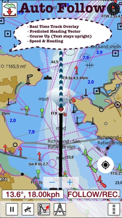
* Auto Follow Mode (Course up)
-Continuously updates boat's location on chart
- Adjustable update frequency
Sample Nautical Charts (please visit http://gpsnauticalcharts.com/main/folio-catalog-nautical-charts-app for complete list)
A Bandar-e Moqam
A Khalij-e Chabahar
A Muscat (Masqat) to Mina' al Fahl
Approaches to Said Bin Sultan Naval Base
B Chiruyeh
B Port Sohar
B Port Sultan Qaboos and Muscat (Masqat)
C Bandar-e Charak
C Bandar Jissah
D Bandar Khayran
D Sir Abu Nu'ayr
E Lavan Oil Terminal
E Qalhat LNG and OMIFCO Terminals
F Khawr al Quway' Anchorage
F Sur
G Qeys Anchorage
H Sirri Oil Terminal
I Bandar-e Lengeh
Masirah to the Strait of Hormuz
Northern Approaches to Masirah
Outer Approaches to Port Salalah (Mina Raysut)
Ra's Hilf Anchorage
Said Bin Sultan Naval Base
Southern Approaches to the Strait of Hormuz
PLEASE NOTE: Continued use of GPS running in the background can dramatically decrease battery life.
更新履歴
- Compiled with latest version of Xcode
- New vector renderer
* Voice Prompts for marine navigation (requires GPS )
-prompts when approaching a boating route marker
-Continous distance and ETA updates
-Alerts when sailing/boating off route
-Alerts when boating in wrong direction
*** For any question, contact support at gpsnauticalcharts.com / http://www.gpsnauticalcharts.com ***
*Route Editing/Creation
-Create routes from scratch
-Edit existing GPX/KML routes.
-Add custom description to any route point.
-Drop markers along route.
* Offline Oman charts.
-Visually draw area to download
-Textual search
-Catalog
-Charts reprojected for WGS84 datum
*Seamless chart quilting of marine charts
*Distance Bearing tool
*Create custom way points
- Using GPS
-Select point on map
-Manually enter latitude & longitude coordinates
*POI layer for marine charts
- Overlay POIs
- POI list derived from the equivalent ENC and contains all categories including Buoy, Light, Harbour facility, Obstr.
*Search POIs/Way points
*Pan/Zoom/My Location
* Record Marine GPS tracks
* View tracks overlay
* Live track animation
* Track analytics/stats
* Export GPX tracks.
-Export to SDCard
-Share GPX trakcs with friends.
* Auto Follow Mode (Course up)
-Continuously updates boat's location on chart
- Adjustable update frequency
Sample Nautical Charts (please visit http://gpsnauticalcharts.com/main/folio-catalog-nautical-charts-app for complete list)
A Bandar-e Moqam
A Khalij-e Chabahar
A Muscat (Masqat) to Mina' al Fahl
Approaches to Said Bin Sultan Naval Base
B Chiruyeh
B Port Sohar
B Port Sultan Qaboos and Muscat (Masqat)
C Bandar-e Charak
C Bandar Jissah
D Bandar Khayran
D Sir Abu Nu'ayr
E Lavan Oil Terminal
E Qalhat LNG and OMIFCO Terminals
F Khawr al Quway' Anchorage
F Sur
G Qeys Anchorage
H Sirri Oil Terminal
I Bandar-e Lengeh
Masirah to the Strait of Hormuz
Northern Approaches to Masirah
Outer Approaches to Port Salalah (Mina Raysut)
Ra's Hilf Anchorage
Said Bin Sultan Naval Base
Southern Approaches to the Strait of Hormuz
PLEASE NOTE: Continued use of GPS running in the background can dramatically decrease battery life.
更新履歴
- Compiled with latest version of Xcode
- New vector renderer
ブログパーツ第二弾を公開しました!ホームページでアプリの順位・価格・周辺ランキングをご紹介頂けます。
ブログパーツ第2弾!
アプリの周辺ランキングを表示するブログパーツです。価格・順位共に自動で最新情報に更新されるのでアプリの状態チェックにも最適です。
ランキング圏外の場合でも周辺ランキングの代わりに説明文を表示にするので安心です。
サンプルが気に入りましたら、下に表示されたHTMLタグをそのままページに貼り付けることでご利用頂けます。ただし、一般公開されているページでご使用頂かないと表示されませんのでご注意ください。
幅200px版
幅320px版
お気に入りのアプリをご紹介頂くためのブログパーツです。アプリの価格や順位表示は毎日自動更新♪
サンプルが気に入りましたら、下に表示されたHTMLタグをそのままページに貼り付けることでご利用頂けます。
※配信を停止させていただく可能性もございますので、タグの改変はご遠慮ください。

Now Loading...

「iPhone & iPad アプリランキング」は、最新かつ詳細なアプリ情報をご紹介しているサイトです。
お探しのアプリに出会えるように様々な切り口でページをご用意しております。
「メニュー」よりぜひアプリ探しにお役立て下さい。
Presents by $$308413110 スマホからのアクセスにはQRコードをご活用ください。 →
Now loading...