Tracks4Africa Navigator |
| このアプリは現在ストアで閲覧することができません。 | ||||


|
価格 | 6000円 | ダウンロード |
|
|---|---|---|---|---|
| ジャンル | ナビゲーション | |||
サイズ | 714.3MB (ダウンロードにWIFIが必要) | |||
| 開発者 | Tracks4Africa | |||
| 順位 |
| |||
| リリース日 | 2013-03-17 08:54:14 | 評価 | 評価が取得できませんでした。 | |
| 互換性 | iOS 7.0以降が必要です。 iPhone、iPad および iPod touch 対応。 | |||
|
||||
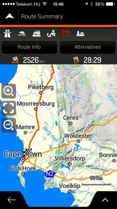
Tracks4Africa Overland Navigator is the iOS version of the Tracks4Africa GPS maps which has been used by travellers for over 10 years to safely navigate them across Africa. This version includes the coverage for the entire Africa. The app provides offline navigation once installed.
For those of you who do not know the Tracks4Africa maps, please note that Tracks4Africa maps are not for common city navigation in South Africa nor does it provide full wall to wall coverage of all countries in Africa. Our maps are compiled from the data contributions of real travellers who are serious about creating a navigation resource which only contains verified roads and points of interest that are useful to the self-drive tourist in Africa. If you intend travelling overland in Africa our maps will work for you.
A Traveller’s Africa is the term we use to describe our map coverage. Where we probably do not cover even 10% of the roads in Africa we know that, after 12 years of community mapping, we cover more than 90% of the roads travelled by self-drive visitors to Africa.
What can you expect from Tracks4Africa maps?
•Integrity. Our maps are built to the standard imposed by the Tracks4Africa Community. This community comprise of serious overland or self-drive travellers in Africa and they visit the most remote destinations in Africa by 4WD, normal car, motorbike, on foot, MTB or even by boat or kayak – some even fly their own aircraft. For this reason our maps can only contain roads and destinations for which we can vouch.
•Relevance. Because the map content is derived from the data contributions of real travellers, our maps are relevant to overland travellers. The maps will answer the most important questions asked by any traveller; where do we sleep, where do we find fuel, where do we eat or buy stuff, what can we see or do here, where do we go in case of an emergency and what should we be aware of, and then a whole lot more.
•Accuracy. All roads are GPS recorded, especially the most remote tracks. We do not lift roads from paper maps hoping they still exist. The ETA calculation of our navigation is based on the average travel times as we get them from real travellers. We have over 14 million km of tracks supporting around 800 000km of roads, so there is a lot of data we can use to calculate these travel times.
List of countries:
South Africa, Namibia, Lesotho, Swaziland, Mozambique, Malawi, Zimbabwe, Zambia, Botswana, Angola, Tanzania, Uganda, Rwanda, Burundi, Kenya, Ethiopia, Egypt, Morocco, Tunisia and many more in between. Countries in between may be limited to overland routes connecting the classic overland destinations in Africa.
The map data in this app is from Tracks4Africa, but we have partnered with NNG to supply the actual application for navigation. If you are familiar with the iGO software you will be right at home with this app as well. If not, we are sure you will find it easy to familiarise yourself with the controls.
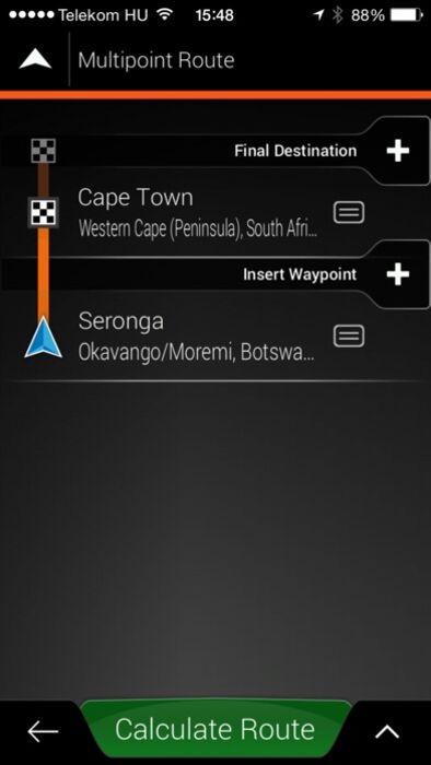
We know that many overland travellers like to plan their trip out in advance and then transfer points to their GPS. The app does not support this feature, but it allows you to plan a route between two destinations so you can see the distance and travel time. Also note that the app is not part of the Garmin GPS ecosystem and you cannot use PC based software to plan trips and transfer to this app, it is a stand-alone navigation and information app.
For more information on our map data and our company please visit our web page or post a question on Facebook.
Please note:
Continued use of GPS running in the background can dramatically decrease battery life.
iPod Touch and iPad with WiFi only:
Note that iPod Touch and iPad with WiFi only, does not have an integrated GPS chip. If you want to use these devices as a navigation device then you need to pair it with an external GPS device. WiFi is not a reliable location service and will yield any navigation app useless in remote areas.
更新履歴
- new version (1807) of T4A maps
For those of you who do not know the Tracks4Africa maps, please note that Tracks4Africa maps are not for common city navigation in South Africa nor does it provide full wall to wall coverage of all countries in Africa. Our maps are compiled from the data contributions of real travellers who are serious about creating a navigation resource which only contains verified roads and points of interest that are useful to the self-drive tourist in Africa. If you intend travelling overland in Africa our maps will work for you.
A Traveller’s Africa is the term we use to describe our map coverage. Where we probably do not cover even 10% of the roads in Africa we know that, after 12 years of community mapping, we cover more than 90% of the roads travelled by self-drive visitors to Africa.
What can you expect from Tracks4Africa maps?
•Integrity. Our maps are built to the standard imposed by the Tracks4Africa Community. This community comprise of serious overland or self-drive travellers in Africa and they visit the most remote destinations in Africa by 4WD, normal car, motorbike, on foot, MTB or even by boat or kayak – some even fly their own aircraft. For this reason our maps can only contain roads and destinations for which we can vouch.
•Relevance. Because the map content is derived from the data contributions of real travellers, our maps are relevant to overland travellers. The maps will answer the most important questions asked by any traveller; where do we sleep, where do we find fuel, where do we eat or buy stuff, what can we see or do here, where do we go in case of an emergency and what should we be aware of, and then a whole lot more.
•Accuracy. All roads are GPS recorded, especially the most remote tracks. We do not lift roads from paper maps hoping they still exist. The ETA calculation of our navigation is based on the average travel times as we get them from real travellers. We have over 14 million km of tracks supporting around 800 000km of roads, so there is a lot of data we can use to calculate these travel times.
List of countries:
South Africa, Namibia, Lesotho, Swaziland, Mozambique, Malawi, Zimbabwe, Zambia, Botswana, Angola, Tanzania, Uganda, Rwanda, Burundi, Kenya, Ethiopia, Egypt, Morocco, Tunisia and many more in between. Countries in between may be limited to overland routes connecting the classic overland destinations in Africa.
The map data in this app is from Tracks4Africa, but we have partnered with NNG to supply the actual application for navigation. If you are familiar with the iGO software you will be right at home with this app as well. If not, we are sure you will find it easy to familiarise yourself with the controls.
We know that many overland travellers like to plan their trip out in advance and then transfer points to their GPS. The app does not support this feature, but it allows you to plan a route between two destinations so you can see the distance and travel time. Also note that the app is not part of the Garmin GPS ecosystem and you cannot use PC based software to plan trips and transfer to this app, it is a stand-alone navigation and information app.
For more information on our map data and our company please visit our web page or post a question on Facebook.
Please note:
Continued use of GPS running in the background can dramatically decrease battery life.
iPod Touch and iPad with WiFi only:
Note that iPod Touch and iPad with WiFi only, does not have an integrated GPS chip. If you want to use these devices as a navigation device then you need to pair it with an external GPS device. WiFi is not a reliable location service and will yield any navigation app useless in remote areas.
更新履歴
- new version (1807) of T4A maps
ブログパーツ第二弾を公開しました!ホームページでアプリの順位・価格・周辺ランキングをご紹介頂けます。
ブログパーツ第2弾!
アプリの周辺ランキングを表示するブログパーツです。価格・順位共に自動で最新情報に更新されるのでアプリの状態チェックにも最適です。
ランキング圏外の場合でも周辺ランキングの代わりに説明文を表示にするので安心です。
サンプルが気に入りましたら、下に表示されたHTMLタグをそのままページに貼り付けることでご利用頂けます。ただし、一般公開されているページでご使用頂かないと表示されませんのでご注意ください。
幅200px版
幅320px版
お気に入りのアプリをご紹介頂くためのブログパーツです。アプリの価格や順位表示は毎日自動更新♪
サンプルが気に入りましたら、下に表示されたHTMLタグをそのままページに貼り付けることでご利用頂けます。
※配信を停止させていただく可能性もございますので、タグの改変はご遠慮ください。

Now Loading...

「iPhone & iPad アプリランキング」は、最新かつ詳細なアプリ情報をご紹介しているサイトです。
お探しのアプリに出会えるように様々な切り口でページをご用意しております。
「メニュー」よりぜひアプリ探しにお役立て下さい。
Presents by $$308413110 スマホからのアクセスにはQRコードをご活用ください。 →
Now loading...