FSWidgets QuickPlan |
| 価格 | 4000円 | ダウンロード |
||
|---|---|---|---|---|
| ジャンル | ナビゲーション | |||
サイズ | 14.9MB | |||
| 開発者 | Fermin Fernandez | |||
| 順位 |
| |||
| リリース日 | 2012-06-20 04:03:42 | 評価 | 評価が取得できませんでした。 | |
| 互換性 | iOS 12.0以降が必要です。 iPad 対応。 | |||
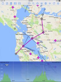
QuickPlan for iPad is a visual touch enabled flight planner that makes it easy to generate flight plans in native FSX, FS2004 or X-Plane formats. It makes a great companion for our moving map app - FSWidgets Navigator.
The entire route is generated visually, by tapping the map to add the departure airport, intermediate waypoints and arrival airport in the same order that you intend flying the plan.
During plan creation and after adding the final arrival waypoint you also have the opportunity to remove any of the intermediate waypoints before saving the plan in your preferred format.
Flight plans are saved to the apps Documents folder, accessible on macOS via the Finder window, or on Windows PC using the iTunes File Sharing feature. For a more convenient file export solution you can use the built-in Dropbox support to easily transfer flight plans to your Mac or PC.
Now includes 40 Aero Chart overlays and Worldwide Nav Data icons (airport, ILS, VOR, NDB, fix).
FEATURE LIST:
- Generates native FSX (.pln), FS2004 (.pln) and X-Plane (.fms) format flight plans
- Saves flight plans to the Documents folder, can be exported/imported
- macOS - Flight plans are accessible on macOS via the Finder window
- Windows PC - Flight plans can be exported via iTunes File Sharing feature
- Includes optional Dropbox support for easy transfer of flight plans to Mac or PC
- Dropbox feature syncs to the folder "Dropbox/Apps/FSWidgets - QuickPlan" on your Mac or PC
- Search for airport by ICAO identifier
- Map powered by Leaflet API (using OpenStreetMap & custom data)
- Includes many world-wide maps styles
- Includes 40 aero chart overlays
- Worldwide Nav Data icons (airport, ILS, VOR, NDB, fix)
- World-wide Metar and TAF Data icons
- US Nexrad (Next-Gen Radar) Data
REQUIREMENTS:
- iPad with iOS 12.0 or later.
- MSFS, FSX, FS2004 or X-Plane.
- Free (or Pro) Dropbox account (if using that feature)
- Dropbox must be installed on Mac or Windows PC
- Wi-Fi network required
- Internet access required, to download map data
更新履歴
- Added 40 Aero Chart overlays (free)
- Added Worldwide Nav Data (free)
ブログパーツ第二弾を公開しました!ホームページでアプリの順位・価格・周辺ランキングをご紹介頂けます。
ブログパーツ第2弾!
アプリの周辺ランキングを表示するブログパーツです。価格・順位共に自動で最新情報に更新されるのでアプリの状態チェックにも最適です。
ランキング圏外の場合でも周辺ランキングの代わりに説明文を表示にするので安心です。
サンプルが気に入りましたら、下に表示されたHTMLタグをそのままページに貼り付けることでご利用頂けます。ただし、一般公開されているページでご使用頂かないと表示されませんのでご注意ください。
幅200px版
幅320px版
Now Loading...

「iPhone & iPad アプリランキング」は、最新かつ詳細なアプリ情報をご紹介しているサイトです。
お探しのアプリに出会えるように様々な切り口でページをご用意しております。
「メニュー」よりぜひアプリ探しにお役立て下さい。
Presents by $$308413110 スマホからのアクセスにはQRコードをご活用ください。 →
Now loading...


