Flyskyhy |


|
価格 | 1300円 | ダウンロード |
|
|---|---|---|---|---|
| ジャンル | スポーツ | |||
サイズ | 30.2MB | |||
| 開発者 | Renevision | |||
| 順位 |
| |||
| リリース日 | 2012-04-18 05:12:50 | 評価 |
|
|
| 互換性 | iOS 12.0以降が必要です。 iPhone、iPad および iPod touch 対応。 | |||
|
||||
 (7人)
(7人)
Flyskyhy forms your flight instrument during flight and shows all information you need for that. You get the normal data like altitude, climb rate, ground speed, and glide angle. But it also calculates and shows the current wind direction and strength, very important for your safety.
A moving and rotating map shows your current flying position and flight trail. It indicates where you have gone up (in a thermal), and where you have had faster than normal decline. With that, you can easily find back that thermal that you lost. The map also shows the nearest known landing spots, and whether they are reachable by normal glide, given your current altitude and wind direction.
Integration with Bluetooth varios SensBox, FlyNet, GoFly iPico, XC-Tracer, BlueFlyVario, or SkyDrop gives accurate altitude and lift information. That turns your iPhone into an full-fletched GPS-vario, including vario tones.
The app makes a full log of your flight, that can be analyzed afterwards. Besides normal data like start and landing positions, duration of flight, and an altitude graph of the flight, Flyskyhy also calculates the scoring distances for you. So you can immediately see whether you have broken that FAI triangle record.
Your live location is reported on livetrack24.com or loctome.com if you desire, so anybody can follow your flight while it is happening. If you are flying together with friends, then their location is shown on your map during your flight. So you never have to wonder anymore whether they are in front of or behind you.
The flight display has multiple screens which are all fully configurable. You can move all elements to other spots, delete and add elements, and resize them.
Through in-app purchases, the app also supports airspaces and waypoints.
The app is optimised for paragliding and hang gliders, but can be used with all kinds of airsports.
Main features during the flight;
• Altitude, climb rate, ground speed, air speed, direction, glide angle and many more
• Wind strength and direction
• Moving map of the flying area
• Spots where you have had lift, great for thermal coring
• Shows whether you can still reach a landing spot with the current altitude and wind
• Live tracking of your flight on livetrack24.com or loctome.com
• Shows live location of your friends during flight
After the flight:
• Full logbook of all your flights
• Basic flight data like start/landing, duration, height difference, distance flown, and many more
• Calculation of 5-points, open triangle, and FAI triangle distances
• Graph of altitude and climb rate
• Signed IGC and KML log files of flights
• Transfer the log to iTunes or send by email
• Upload the flight directly to XContest, ParaglidingForum, DHV-XC, and other Leonardo servers
• Open flight in Google Earth on the iPhone
• Replay the flight and relive it!
By purchasing the Waypoints Extension you get access to:
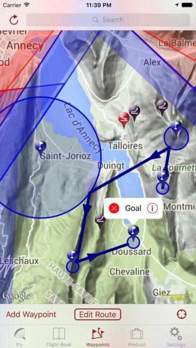
• A fully zoomable and scrollable map with the waypoints and optimised route. The map also shows start and landing spots, as well as restricted airspaces (with the Airspace Extension)
• Enter new waypoints, either on the map or by specifying the parameters
• Full route support with start time, goal, entry/exit points, etc.
• Many instruments to guide you along the route
• Visible and audible indication when a waypoint has been reached
• Complete waypoints organiser
• Import and export of various waypoint file formats
By purchasing the Airspace Extension you get access to:
• Airspaces of 30 countries
• Display of airspaces on the map with configurable colors and formats
• Display of your vertical position w.r.t. airspaces
• Visible and audible warnings when approaching and entering an airspace
• Shows local airspaces by touching a spot on the map
Note: a live internet connection is required for live tracking of your and your friends locations
Note: continuous GPS and screen usage makes the battery drain faster than normal
更新履歴
We keep fixing bugs and adding small improvements to make your experience better.
A moving and rotating map shows your current flying position and flight trail. It indicates where you have gone up (in a thermal), and where you have had faster than normal decline. With that, you can easily find back that thermal that you lost. The map also shows the nearest known landing spots, and whether they are reachable by normal glide, given your current altitude and wind direction.
Integration with Bluetooth varios SensBox, FlyNet, GoFly iPico, XC-Tracer, BlueFlyVario, or SkyDrop gives accurate altitude and lift information. That turns your iPhone into an full-fletched GPS-vario, including vario tones.
The app makes a full log of your flight, that can be analyzed afterwards. Besides normal data like start and landing positions, duration of flight, and an altitude graph of the flight, Flyskyhy also calculates the scoring distances for you. So you can immediately see whether you have broken that FAI triangle record.
Your live location is reported on livetrack24.com or loctome.com if you desire, so anybody can follow your flight while it is happening. If you are flying together with friends, then their location is shown on your map during your flight. So you never have to wonder anymore whether they are in front of or behind you.
The flight display has multiple screens which are all fully configurable. You can move all elements to other spots, delete and add elements, and resize them.
Through in-app purchases, the app also supports airspaces and waypoints.
The app is optimised for paragliding and hang gliders, but can be used with all kinds of airsports.
Main features during the flight;
• Altitude, climb rate, ground speed, air speed, direction, glide angle and many more
• Wind strength and direction
• Moving map of the flying area
• Spots where you have had lift, great for thermal coring
• Shows whether you can still reach a landing spot with the current altitude and wind
• Live tracking of your flight on livetrack24.com or loctome.com
• Shows live location of your friends during flight
After the flight:
• Full logbook of all your flights
• Basic flight data like start/landing, duration, height difference, distance flown, and many more
• Calculation of 5-points, open triangle, and FAI triangle distances
• Graph of altitude and climb rate
• Signed IGC and KML log files of flights
• Transfer the log to iTunes or send by email
• Upload the flight directly to XContest, ParaglidingForum, DHV-XC, and other Leonardo servers
• Open flight in Google Earth on the iPhone
• Replay the flight and relive it!
By purchasing the Waypoints Extension you get access to:
• A fully zoomable and scrollable map with the waypoints and optimised route. The map also shows start and landing spots, as well as restricted airspaces (with the Airspace Extension)
• Enter new waypoints, either on the map or by specifying the parameters
• Full route support with start time, goal, entry/exit points, etc.
• Many instruments to guide you along the route
• Visible and audible indication when a waypoint has been reached
• Complete waypoints organiser
• Import and export of various waypoint file formats
By purchasing the Airspace Extension you get access to:
• Airspaces of 30 countries
• Display of airspaces on the map with configurable colors and formats
• Display of your vertical position w.r.t. airspaces
• Visible and audible warnings when approaching and entering an airspace
• Shows local airspaces by touching a spot on the map
Note: a live internet connection is required for live tracking of your and your friends locations
Note: continuous GPS and screen usage makes the battery drain faster than normal
更新履歴
We keep fixing bugs and adding small improvements to make your experience better.
ブログパーツ第二弾を公開しました!ホームページでアプリの順位・価格・周辺ランキングをご紹介頂けます。
ブログパーツ第2弾!
アプリの周辺ランキングを表示するブログパーツです。価格・順位共に自動で最新情報に更新されるのでアプリの状態チェックにも最適です。
ランキング圏外の場合でも周辺ランキングの代わりに説明文を表示にするので安心です。
サンプルが気に入りましたら、下に表示されたHTMLタグをそのままページに貼り付けることでご利用頂けます。ただし、一般公開されているページでご使用頂かないと表示されませんのでご注意ください。
幅200px版
幅320px版
お気に入りのアプリをご紹介頂くためのブログパーツです。アプリの価格や順位表示は毎日自動更新♪
サンプルが気に入りましたら、下に表示されたHTMLタグをそのままページに貼り付けることでご利用頂けます。
※配信を停止させていただく可能性もございますので、タグの改変はご遠慮ください。

Now Loading...

「iPhone & iPad アプリランキング」は、最新かつ詳細なアプリ情報をご紹介しているサイトです。
お探しのアプリに出会えるように様々な切り口でページをご用意しております。
「メニュー」よりぜひアプリ探しにお役立て下さい。
Presents by $$308413110 スマホからのアクセスにはQRコードをご活用ください。 →
Now loading...