OvitalMap |
| この情報はストアのものより古い可能性がございます。 | ||||
|
価格 | 無料 | ダウンロード |
|
|---|---|---|---|---|
| ジャンル | ナビゲーション | |||
サイズ | 81.6MB | |||
| 開発者 | Beijing Ovital Software Co.,Ltd. | |||
| 順位 |
| |||
| リリース日 | 2012-05-10 10:13:23 | 評価 | 評価が取得できませんでした。 | |
| 互換性 | iOS 8.0以降が必要です。 iPhone、iPad および iPod touch 対応。 | |||
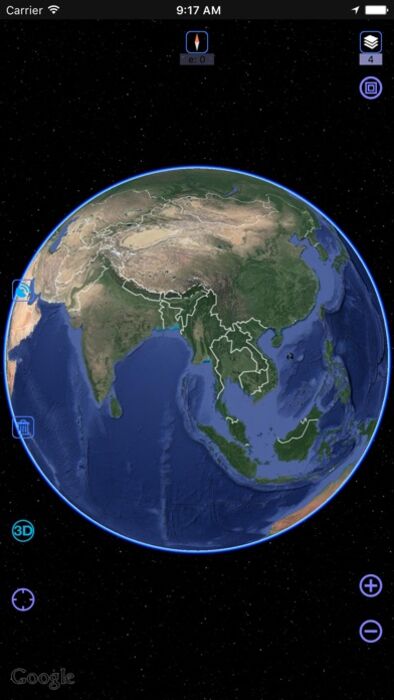
OvitalMap is a map browser developed by Beijing Ovital Software Co.,Ltd. based on Google API, supporting offline views of Google Map, satellite map and terrain map, as well as voice navigation.
OvitalMap has the following features:
1、 Support a variety of well-known maps
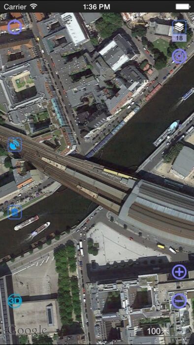
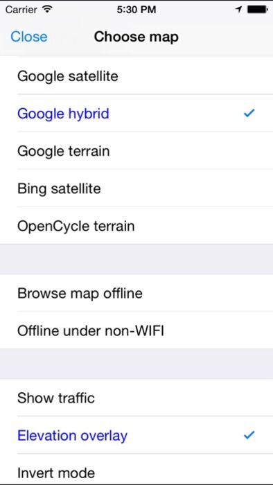
At present it supports Google map, Google satellite map and Google terrain map. The user can easily switch between these maps. The maps can be downloaded for offline applications to save 3G traffic.
2、 Route search
Google API offers a search engine to choose the best route for you. It will find an optimum solution for your travel, either by walk,bus or driving.
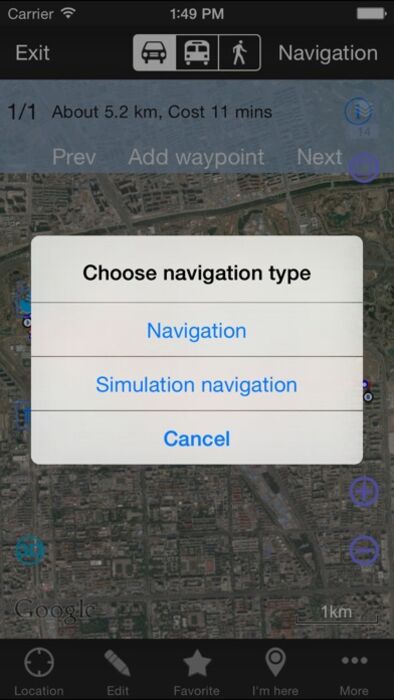
3、 Interactive voice navigation
There will be voice navigation for the walk or driving route suggested by the system. The location of friends will be shown on the map dynamically so that you can know where they are and don’t need to worry losing their positions any more. The system can highlight moving tracks of more than one friend with lines of different colors.
4、 Information search
The API search engine will offer information about your location, roads, and buses, as well as hotels, entertainment, banks, restaurants, supermarkets, gas stations, parking lots, and tourist attractions nearby a certain position. Catering and entertainment providers can also be sorted by price or customer ranking.
5、 Location sharing
You can share your location at a certain moment with selected relatives or friends so that they will know your position on the map.
6、 Communication with friends
When you are using the system to chat with a friend (just like using QQ or MSN), you can insert a location tag, travel solution, or a map created by yourself. After receiving the insertmessage, he can have it shown on his map by a simple click. Thus, if you know the position of your friend, you can draw a route on the map and send it to him. The route will be shown on his map for him to follow.
7、 Track record
The system can record your tracks, which can be saved and sent to friends.
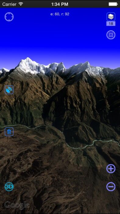
8. Elevation data service, the Cloud of Ovitalmap integrate SRTM3 elevation data around the world. You can quickly see about any place’s altitude in the world. We also can direct output the contour line in 10 meters on the satellite map, which helps you directly see the elevation data on satellite map.
9. Real 3D map, which is similar to Google Earth, combines the satellite map and elevation data, and can show the real terrain of the world.
-----------------------------------------------------------
Continued use of GPS running in the background can dramatically decrease battery life.
更新履歴
1. Adapt to iOS13
2. Add a quick design toolbar
3. Track adds two new line types
4. Support vector map format OSM (openstreetmap vector map)
5. Optimized 3D module
6. Other bug fixes and feature optimization
OvitalMap has the following features:
1、 Support a variety of well-known maps
At present it supports Google map, Google satellite map and Google terrain map. The user can easily switch between these maps. The maps can be downloaded for offline applications to save 3G traffic.
2、 Route search
Google API offers a search engine to choose the best route for you. It will find an optimum solution for your travel, either by walk,bus or driving.
3、 Interactive voice navigation
There will be voice navigation for the walk or driving route suggested by the system. The location of friends will be shown on the map dynamically so that you can know where they are and don’t need to worry losing their positions any more. The system can highlight moving tracks of more than one friend with lines of different colors.
4、 Information search
The API search engine will offer information about your location, roads, and buses, as well as hotels, entertainment, banks, restaurants, supermarkets, gas stations, parking lots, and tourist attractions nearby a certain position. Catering and entertainment providers can also be sorted by price or customer ranking.
5、 Location sharing
You can share your location at a certain moment with selected relatives or friends so that they will know your position on the map.
6、 Communication with friends
When you are using the system to chat with a friend (just like using QQ or MSN), you can insert a location tag, travel solution, or a map created by yourself. After receiving the insertmessage, he can have it shown on his map by a simple click. Thus, if you know the position of your friend, you can draw a route on the map and send it to him. The route will be shown on his map for him to follow.
7、 Track record
The system can record your tracks, which can be saved and sent to friends.
8. Elevation data service, the Cloud of Ovitalmap integrate SRTM3 elevation data around the world. You can quickly see about any place’s altitude in the world. We also can direct output the contour line in 10 meters on the satellite map, which helps you directly see the elevation data on satellite map.
9. Real 3D map, which is similar to Google Earth, combines the satellite map and elevation data, and can show the real terrain of the world.
-----------------------------------------------------------
Continued use of GPS running in the background can dramatically decrease battery life.
更新履歴
1. Adapt to iOS13
2. Add a quick design toolbar
3. Track adds two new line types
4. Support vector map format OSM (openstreetmap vector map)
5. Optimized 3D module
6. Other bug fixes and feature optimization
ブログパーツ第二弾を公開しました!ホームページでアプリの順位・価格・周辺ランキングをご紹介頂けます。
ブログパーツ第2弾!
アプリの周辺ランキングを表示するブログパーツです。価格・順位共に自動で最新情報に更新されるのでアプリの状態チェックにも最適です。
ランキング圏外の場合でも周辺ランキングの代わりに説明文を表示にするので安心です。
サンプルが気に入りましたら、下に表示されたHTMLタグをそのままページに貼り付けることでご利用頂けます。ただし、一般公開されているページでご使用頂かないと表示されませんのでご注意ください。
幅200px版
幅320px版
お気に入りのアプリをご紹介頂くためのブログパーツです。アプリの価格や順位表示は毎日自動更新♪
サンプルが気に入りましたら、下に表示されたHTMLタグをそのままページに貼り付けることでご利用頂けます。
※配信を停止させていただく可能性もございますので、タグの改変はご遠慮ください。

Now Loading...

「iPhone & iPad アプリランキング」は、最新かつ詳細なアプリ情報をご紹介しているサイトです。
お探しのアプリに出会えるように様々な切り口でページをご用意しております。
「メニュー」よりぜひアプリ探しにお役立て下さい。
Presents by $$308413110 スマホからのアクセスにはQRコードをご活用ください。 →
Now loading...