InFlight - attitude, flight instruments, terrain, obstacles and airports on a glass cockpit display with moving map |
| この情報はストアのものより古い可能性がございます。 | ||||
|
価格 | 600円 | ダウンロード |
|
|---|---|---|---|---|
| ジャンル | ナビゲーション | |||
サイズ | 864.4KB | |||
| 開発者 | BBFlight LLC | |||
| 順位 |
| |||
| リリース日 | 2010-12-17 06:01:45 | |||
| 評価 | 評価が取得できませんでした。 | |||
| 互換性 | iOS 4.1以降が必要です。 iPhone、iPad および iPod touch 対応。 | |||
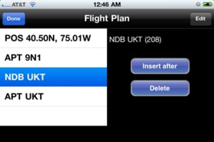
InFlight features gyro attitude and primary flight instruments on a glass-cockpit display, and a moving map with airports, navaids, terrain and obstacle warnings. InFlight offers graphical and text-based flight planning with easy flight plan modification.
InFlight has three main views:
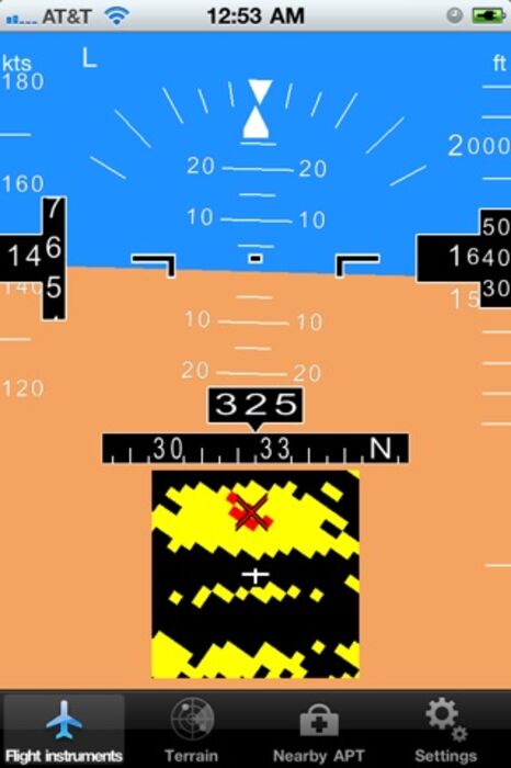
1) Primary Flight Display with gyro-based attitude indicator with slip and rate-of-turn indicators, speed, altitude and heading tapes, and nearby airport information. If nearby terrain or obstacles are within 1000ft of your aircraft, a pop-up terrain/obstacle map will appear on this screen. Heading tape shows track and bearing lines for navigation along your flight plan
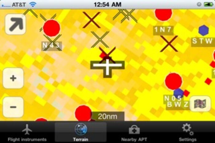
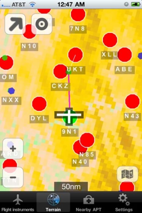
2) Moving map with airports, navaids (VOR/NDB), terrain and obstacles, and flight plan navigation. Airports are color-coded to indicate glide range. Terrain shows elevation shading and yellow/red warnings. Flight plans can be constructed by double-tapping items on the map, or through text entry of a series of waypoints
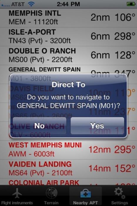
3) List of nearby airports, with color coding to determine which ones are within gliding range. Airport information includes distance, bearing, and length of longest runway
InFlight requires purchase of a regional database at minimal cost (~$2.99 per quarter), to maintain current terrain/navaid/obstacle/airport information. Databases expire every first day of the quarter and are available 10 days before the end of the quarter.
We offer databases for North America, Europe, Asia, Oceania (Australia & New Zealand) and South America. Airport, navaid and elevation data is available everywhere. Obstacle information is currently only available for North America.
DEVICE REQUIREMENTS: For full functionality this app requires a device with GPS. For gyro-based attitude indication, gyro sensors are required (currently only available for the iPhone 4). If no gyro sensors are available, attitude will be derived from GPS.
WARNING: This app and Apple products are not FAA approved and should not be used for primary navigation. All information is presented for reference only. You assume total responsibility and risk associated with this application
更新履歴
Further improved attitude algorithm, combining gyro, GPS and accelerometer data for stable and reliable attitude indication
InFlight has three main views:
1) Primary Flight Display with gyro-based attitude indicator with slip and rate-of-turn indicators, speed, altitude and heading tapes, and nearby airport information. If nearby terrain or obstacles are within 1000ft of your aircraft, a pop-up terrain/obstacle map will appear on this screen. Heading tape shows track and bearing lines for navigation along your flight plan
2) Moving map with airports, navaids (VOR/NDB), terrain and obstacles, and flight plan navigation. Airports are color-coded to indicate glide range. Terrain shows elevation shading and yellow/red warnings. Flight plans can be constructed by double-tapping items on the map, or through text entry of a series of waypoints
3) List of nearby airports, with color coding to determine which ones are within gliding range. Airport information includes distance, bearing, and length of longest runway
InFlight requires purchase of a regional database at minimal cost (~$2.99 per quarter), to maintain current terrain/navaid/obstacle/airport information. Databases expire every first day of the quarter and are available 10 days before the end of the quarter.
We offer databases for North America, Europe, Asia, Oceania (Australia & New Zealand) and South America. Airport, navaid and elevation data is available everywhere. Obstacle information is currently only available for North America.
DEVICE REQUIREMENTS: For full functionality this app requires a device with GPS. For gyro-based attitude indication, gyro sensors are required (currently only available for the iPhone 4). If no gyro sensors are available, attitude will be derived from GPS.
WARNING: This app and Apple products are not FAA approved and should not be used for primary navigation. All information is presented for reference only. You assume total responsibility and risk associated with this application
更新履歴
Further improved attitude algorithm, combining gyro, GPS and accelerometer data for stable and reliable attitude indication

InFlight - attitude, flight instruments, terrain, obstacles and airports on a glass cockpit display with moving map の
- アプリをゲット!
- このアプリは現在入手できません。
- アプリを教える


- アプリを探す
Now Loading...

「iPhone & iPad アプリランキング」は、最新かつ詳細なアプリ情報をご紹介しているサイトです。
お探しのアプリに出会えるように様々な切り口でページをご用意しております。
「メニュー」よりぜひアプリ探しにお役立て下さい。
Presents by $$308413110 スマホからのアクセスにはQRコードをご活用ください。 →
Now loading...