iGIS for iPad |


|
価格 | 無料 | ダウンロード |
|
|---|---|---|---|---|
| ジャンル | ナビゲーション | |||
サイズ | 74.6MB | |||
| 開発者 | Geometry | |||
| 順位 |
| |||
| リリース日 | 2010-08-26 05:59:10 | 評価 |
|
|
| 互換性 | iOS 9.0以降が必要です。 iPad 対応。 | |||
 (1人)
(1人)
iGIS - The world's first and leading iOS GIS.
True GIS functionality is now available on the iPad! Your iPad. Your data. Your maps.
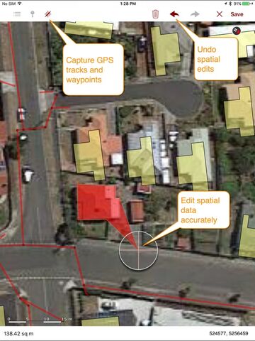
iGIS represents a new era in mobile GIS solutions by enabling users to load, view, investigate, create and export their own data over a background of map service imagery.
Importing data is easy with our unique data import facility supporting Mac, PC and Linux or via the USB cable. ESRI Shapefiles (.shp) are supported at the moment.
Great for field work as your spatial data is stored on the iPad, so there is no need for an Internet connection to see your data. We also support over 3000 projections, so there is no need for data re-projection.
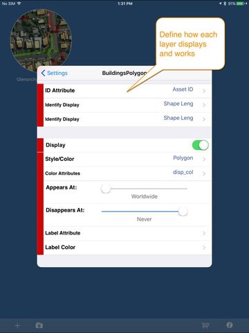
We include support for multiple layers of points, lines, and polygons and imagery – all styled as you like.
Add comments to your maps - A point layer is added with a name and description field. You can add or edit any of your layers - and even define your own data entry forms with dropdown lists for codes, etc.
Export your layers to ESRI shapefiles for use back in your enterprise.
Other features include:
- Great speed, using our multi-threaded map renderer.
- Support for large datasets.
- Add your own imagery
- Import and export of ESRI Shapefiles.
- Display current GPS location in your chosen projection ( + compass)
- Zoom to current location
- Zoom to data extent
- Map Pan, zoom in, zoom out
- Changeable drawing styles for a layer: size, color, transparency
- Set the draw order and visibility of map layers
- Set the zoom scale for layers via a simple slider
- Select and interrogate feature attributes via point and click
This application is designed for GIS professionals and an understanding of some basic GIS concepts such as layers, shapefiles, projections etc, would make using iGIS simpler. Please let us know if concepts in iGIS are unclear.
We know there’s a lot more functionality that we haven’t included. Let us know what features you’d like to see added or improved.
iGIS can use the GPS in the background. Continued use of GPS running in the background can dramatically decrease battery life.
Thanks for your interest,
The Geometry Team
更新履歴
Added support for GDA 2020
True GIS functionality is now available on the iPad! Your iPad. Your data. Your maps.
iGIS represents a new era in mobile GIS solutions by enabling users to load, view, investigate, create and export their own data over a background of map service imagery.
Importing data is easy with our unique data import facility supporting Mac, PC and Linux or via the USB cable. ESRI Shapefiles (.shp) are supported at the moment.
Great for field work as your spatial data is stored on the iPad, so there is no need for an Internet connection to see your data. We also support over 3000 projections, so there is no need for data re-projection.
We include support for multiple layers of points, lines, and polygons and imagery – all styled as you like.
Add comments to your maps - A point layer is added with a name and description field. You can add or edit any of your layers - and even define your own data entry forms with dropdown lists for codes, etc.
Export your layers to ESRI shapefiles for use back in your enterprise.
Other features include:
- Great speed, using our multi-threaded map renderer.
- Support for large datasets.
- Add your own imagery
- Import and export of ESRI Shapefiles.
- Display current GPS location in your chosen projection ( + compass)
- Zoom to current location
- Zoom to data extent
- Map Pan, zoom in, zoom out
- Changeable drawing styles for a layer: size, color, transparency
- Set the draw order and visibility of map layers
- Set the zoom scale for layers via a simple slider
- Select and interrogate feature attributes via point and click
This application is designed for GIS professionals and an understanding of some basic GIS concepts such as layers, shapefiles, projections etc, would make using iGIS simpler. Please let us know if concepts in iGIS are unclear.
We know there’s a lot more functionality that we haven’t included. Let us know what features you’d like to see added or improved.
iGIS can use the GPS in the background. Continued use of GPS running in the background can dramatically decrease battery life.
Thanks for your interest,
The Geometry Team
更新履歴
Added support for GDA 2020
ブログパーツ第二弾を公開しました!ホームページでアプリの順位・価格・周辺ランキングをご紹介頂けます。
ブログパーツ第2弾!
アプリの周辺ランキングを表示するブログパーツです。価格・順位共に自動で最新情報に更新されるのでアプリの状態チェックにも最適です。
ランキング圏外の場合でも周辺ランキングの代わりに説明文を表示にするので安心です。
サンプルが気に入りましたら、下に表示されたHTMLタグをそのままページに貼り付けることでご利用頂けます。ただし、一般公開されているページでご使用頂かないと表示されませんのでご注意ください。
幅200px版
幅320px版
お気に入りのアプリをご紹介頂くためのブログパーツです。アプリの価格や順位表示は毎日自動更新♪
サンプルが気に入りましたら、下に表示されたHTMLタグをそのままページに貼り付けることでご利用頂けます。
※配信を停止させていただく可能性もございますので、タグの改変はご遠慮ください。

Now Loading...

「iPhone & iPad アプリランキング」は、最新かつ詳細なアプリ情報をご紹介しているサイトです。
お探しのアプリに出会えるように様々な切り口でページをご用意しております。
「メニュー」よりぜひアプリ探しにお役立て下さい。
Presents by $$308413110 スマホからのアクセスにはQRコードをご活用ください。 →
Now loading...