London Bus by Zuti |


|
価格 | 無料 | ダウンロード |
|
|---|---|---|---|---|
| ジャンル | 旅行 | |||
サイズ | 74.2MB | |||
| 開発者 | Visual IT Ltd | |||
| 順位 |
| |||
| リリース日 | 2010-04-24 04:14:35 | 評価 |
|
|
| 互換性 | iOS 8.0以降が必要です。 iPhone、iPad および iPod touch 対応。 | |||
 (1人)
(1人)
Now travelling by bus in London has never been easier!
● Fast, simple and intuitive to use.
● Works anywhere, including on a plane, underground and with data roaming turned off.
● Live bus countdown information (internet required).
● The only bus app with a inbuilt bus map.
● Lists every street in 450 square miles.
● Map and routing data are all stored on the device.
● Animates the route and allows tracking of the journey using GPS.
● No waiting for an internet connection.
● Saves battery power and roaming charges.
● Streets, Places of interest etc built into the application.
● OVERVIEW
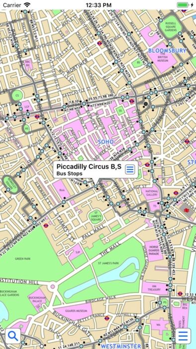
The new London bus application makes it easy to travel in and around the city by bus. Unlike old fashioned schematic style maps this product contains a geographically accurate map showing streets, parks and places of interest etc.
● MAP
The map is hand drawn by Visual IT and provides a unique geographically based view of London bus routes covering 450 square miles so you can easily get your bearings when travelling around the city. You can also use your inbuilt GPS to accurately locate and track yourself and see the nearest transportation stop and distance to it. This is the only public transportation route planner with this ability.
Tap on the map for location information, use the inbuilt search feature or choose from a list of locations. Places of interest, museums, hotels, parks, restaurant, shops, hospitals, streets, etc, are also included. The route planner will automatically suggest the nearest stop to any place of interest you select.
Now with the ability to place markers, routes and areas of interest directly on the map for future reference.
● MINUTE MAP
Another unique feature is the “Minute Map” option which allows you to see the travel times from a start point to all other locations on the map. This is a great way to view the topology of a city and gauge travelling times.
● ROUTING
The application does not require an internet connection and will always be available to display a clear and detailed view of the bus routes, plus list and animate the optimum route for your journey. This product provides the fastest route calculations of any mobile routing application using actual published journey times with the ability to select the quickest route or the route with the least changes.
● LIVE INFO
When an internet connection is available, optional "Live Information" on the current state of the transport services can be viewed allowing you to plan your journeys in advance and avoid any potential delays. Unique to this application is the ability to turn off services that are out of action and automatically calculate an alternative route.
● LIVE BUS DEPARTURES
Also included is the ability to view live bus departure (data supplied by TFL) for any of the bus stops supporting this data feed.
● MORE MAPS
This map is one in a series of Zuti worldwide city maps, if you like this product you may also enjoy some of our other offerings, please visit www.zuti.co.uk for further information.
更新履歴
This app has been updated by Apple to display the Apple Watch app icon.
Updated app for latest iOS
● Fast, simple and intuitive to use.
● Works anywhere, including on a plane, underground and with data roaming turned off.
● Live bus countdown information (internet required).
● The only bus app with a inbuilt bus map.
● Lists every street in 450 square miles.
● Map and routing data are all stored on the device.
● Animates the route and allows tracking of the journey using GPS.
● No waiting for an internet connection.
● Saves battery power and roaming charges.
● Streets, Places of interest etc built into the application.
● OVERVIEW
The new London bus application makes it easy to travel in and around the city by bus. Unlike old fashioned schematic style maps this product contains a geographically accurate map showing streets, parks and places of interest etc.
● MAP
The map is hand drawn by Visual IT and provides a unique geographically based view of London bus routes covering 450 square miles so you can easily get your bearings when travelling around the city. You can also use your inbuilt GPS to accurately locate and track yourself and see the nearest transportation stop and distance to it. This is the only public transportation route planner with this ability.
Tap on the map for location information, use the inbuilt search feature or choose from a list of locations. Places of interest, museums, hotels, parks, restaurant, shops, hospitals, streets, etc, are also included. The route planner will automatically suggest the nearest stop to any place of interest you select.
Now with the ability to place markers, routes and areas of interest directly on the map for future reference.
● MINUTE MAP
Another unique feature is the “Minute Map” option which allows you to see the travel times from a start point to all other locations on the map. This is a great way to view the topology of a city and gauge travelling times.
● ROUTING
The application does not require an internet connection and will always be available to display a clear and detailed view of the bus routes, plus list and animate the optimum route for your journey. This product provides the fastest route calculations of any mobile routing application using actual published journey times with the ability to select the quickest route or the route with the least changes.
● LIVE INFO
When an internet connection is available, optional "Live Information" on the current state of the transport services can be viewed allowing you to plan your journeys in advance and avoid any potential delays. Unique to this application is the ability to turn off services that are out of action and automatically calculate an alternative route.
● LIVE BUS DEPARTURES
Also included is the ability to view live bus departure (data supplied by TFL) for any of the bus stops supporting this data feed.
● MORE MAPS
This map is one in a series of Zuti worldwide city maps, if you like this product you may also enjoy some of our other offerings, please visit www.zuti.co.uk for further information.
更新履歴
This app has been updated by Apple to display the Apple Watch app icon.
Updated app for latest iOS
ブログパーツ第二弾を公開しました!ホームページでアプリの順位・価格・周辺ランキングをご紹介頂けます。
ブログパーツ第2弾!
アプリの周辺ランキングを表示するブログパーツです。価格・順位共に自動で最新情報に更新されるのでアプリの状態チェックにも最適です。
ランキング圏外の場合でも周辺ランキングの代わりに説明文を表示にするので安心です。
サンプルが気に入りましたら、下に表示されたHTMLタグをそのままページに貼り付けることでご利用頂けます。ただし、一般公開されているページでご使用頂かないと表示されませんのでご注意ください。
幅200px版
幅320px版
お気に入りのアプリをご紹介頂くためのブログパーツです。アプリの価格や順位表示は毎日自動更新♪
サンプルが気に入りましたら、下に表示されたHTMLタグをそのままページに貼り付けることでご利用頂けます。
※配信を停止させていただく可能性もございますので、タグの改変はご遠慮ください。

Now Loading...

「iPhone & iPad アプリランキング」は、最新かつ詳細なアプリ情報をご紹介しているサイトです。
お探しのアプリに出会えるように様々な切り口でページをご用意しております。
「メニュー」よりぜひアプリ探しにお役立て下さい。
Presents by $$308413110 スマホからのアクセスにはQRコードをご活用ください。 →
Now loading...