iHikeGPS : Classic Topo Maps |
| このアプリは現在ストアで閲覧することができません。 | ||||
|
価格 | 700円 | ダウンロード |
|
|---|---|---|---|---|
| ジャンル | ナビゲーション | |||
サイズ | 11.7MB | |||
| 開発者 | James Associates Inc. | |||
| 順位 |
| |||
| リリース日 | 2010-02-12 17:00:00 | 評価 | 評価が取得できませんでした。 | |
| 互換性 | iOS 12.0以降が必要です。 iPhone、iPad および iPod touch 対応。 | |||
|
||||
Unleash the navigation potential of your iPhone or iPad with iHikeGPS! Turn your device into a high-performance GPS receiver, equipped with USGS, US Forest Service & Canadian topo maps. These Classic topo map quads often have valuable back country details that vector maps in other hiking apps don't show.
Even in remote areas with no cell signal, iHikeGPS ensures you always know where you've been, where you are, and where you’re going. Experience the ultimate hiking companion, offering unparalleled track recording, route navigation & accurate Estimated Time of Arrival.
iHikeGPS eliminates sign-ups, ads, subscriptions & in-app purchases, making it more affordable, hassle-free & respectful of your privacy.
Discover the limitless possibilities of iHikeGPS while hiking, backpacking, biking, canoeing, geocaching, camping, sightseeing, 4WD exploring & hunting. Recommended as the top choice in “Essential Gear for Safe Hiking”, it's a must-have for outdoor enthusiasts.
TRACKS, WAYPOINTS & ROUTES
Record tracks as you hike, even in the background. View them on the map with a Trip Timer & Odometer.
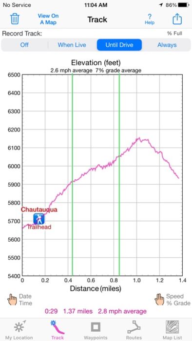
View elevation graphs of your tracks & routes. Show date, time, average speed and % grade. Measure the area inside a closed path.
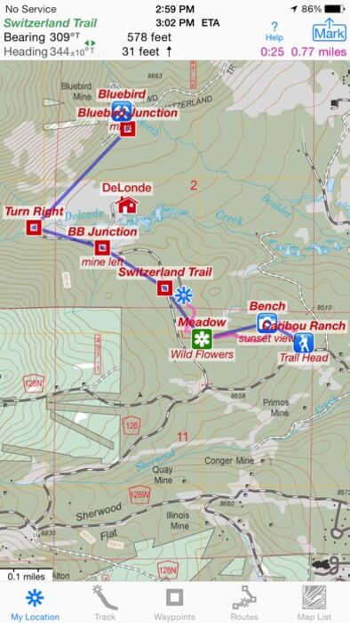
Mark waypoints precisely using topo or satellite maps, place names or addresses, geotagged photos or by projecting from a known point.
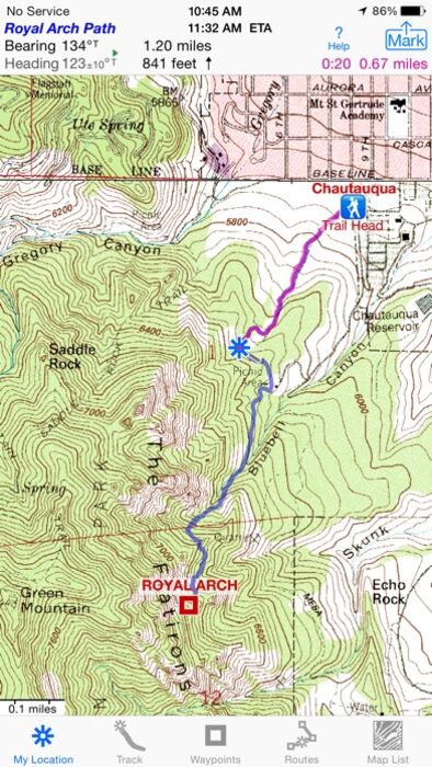
Set a quick GoTo waypoint or a full route & see the heading, direction, distance, elevation change and Estimated Time of Arrival at your destination & intermediate waypoints along the trail.
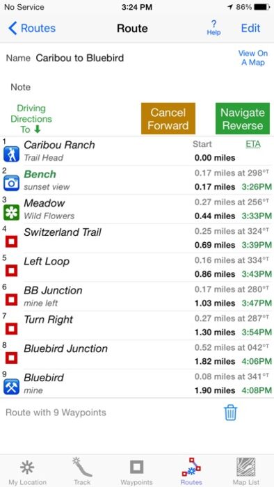
Create customized routes using waypoints, recorded tracks, or imported GPX, KML or TCX files. Advanced route editing.
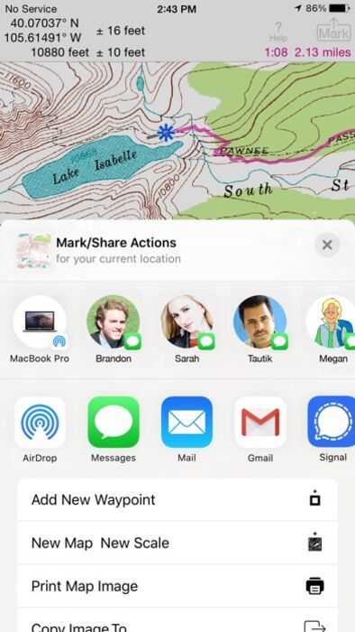
Send waypoint, route, track & map list files via AirDrop, eMail, Messages or iCloud Drive.
View the sun & moon position, rise times, & set times for any date & place on earth.
Send data to other apps such as Google Earth.
TOPO MAPS AT NO EXTRA COST
USA: Newest US Forest Service FSTopo 24K maps
USGS 24K maps for all 50 states, Guam, Puerto Rico & the US Virgin Islands
USGS 250K & 100K (63K for Alaska) maps for all states
Canada: National Resources Canada 50K maps for all areas south of 50° latitude. For Alberta, British Columbia & Newfoundland, coverage extends to 54° latitude.
Download using WiFi or cell service. Our maps are optimized to download faster & use less storage memory. Store up to 2200 maps to use in the wilderness without cell service.
These beautiful richly detailed offline topographic map images stitch together for seamless coverage across map boundaries.
Print & Share map images overlaid with waypoints, routes & tracks.
Measure distance and direction between any 2 points.
USE THE UNITS YOU PREFER
Miles, Nautical miles or Km
Feet or Meters
Degrees, Degrees/Minutes, Degrees/Minutes/Seconds, UTM or USNG-MGRS
°True or °Magnetic
HOW TOS
Comprehensive Help in the App
Online Manual on iHikeGPS.com
Email developer: lwjames@iHikeGPS.com
WHAT OTHERS SAY
“I am VERY impressed!!!…It pretty much blows…, my previous fave GPS app, out of the water. Your track recording features, fast map downloads, and well thought out interface make it a real winner. It's very sophisticated software, and makes my iPhone just about as good as $600 Garmin… Actually better, in a lot of ways”-John in OR
“Perfect for anyone camping, fishing & hiking, it'll provide great detail when you need it the most…for anyone who takes the great outdoors seriously”-David's review
“thank you for developing IHIKE GPS…what a great product it is. I am impressed!…I use it hiking, biking, skiing & Jeeping”-Ammon in CO
DEVICE REQUIREMENTS
Use iHikeGPS on any iOS device even if you don't have a cellular data plan for it. iPhones & WiFi+cellular iPads support full navigation. WiFi-only iPads & iPod touch can view maps, but require an iOS-compatible external GPS receiver to show your location & record tracks.
Join thousands of satisfied users who rely on iHikeGPS for their outdoor adventures!
更新履歴
I use this app daily on trails in Colorado. We're continually improving it to be even more useful! This version adds the ability to view a weather report for any location.
What's new in iHikeGPS when compared with other available USA and Canada topo map apps?
• Real Navigation Power: Unlike other apps that simply display waypoints and routes on a map, iHikeGPS empowers you to do real navigation to those waypoints and along those routes while receiving crucial information such as Estimated Time of Arrival, current bearing, and remaining distance and elevation gain to intermediate and final destinations. Use other available apps to find trails to hike. Use iHikeGPS when you are on the trail and away from cell service.
• With iHikeGPS, you receive the very latest US Forest Service maps at no additional charge. These maps show many new and more accurately placed trails, numbered Forest Service roads, buildings, and other important details. They show forested areas and inholdings so you know if you are on Forest Service land or private land. None of these maps are older than 2015, and many are even more recent. If you venture into Wilderness Areas or National Forest Service lands, these USFS maps will be invaluable to you. Don't settle for hiking apps which don't offer US Forest Service topo maps, or which say they include US Forest Service maps, but actually just give you the outdated 2013 versions.
• You can view an elevation graph of your tracks and your routes with speed, % grade, and nearby waypoints shown on it.
• You can create, import, edit, and navigate both on routes based on a recorded or imported path, and on routes based on a series of waypoints.
• iHikeGPS' s code size is kept very small by efficient programming, so in an emergency you can download it easily even over a weak cell connection.
• The current version of iHikeGPS runs on the latest devices and also on older devices with older versions of iOS , all the way back to devices such as the iPhone 6.
• There is never any confusion over what maps you have available offline. They are clearly listed by USGS quad name and shown on an overview map.
• Check the App Privacy section. We don't know who you are when you are using iHikeGPS. We never send your current location or your recorded track to our servers. Hence we cannot and don't use your location data. We cannot and don't provide your location data to anyone else. Unlike other mapping apps that profit from using your location data in ways that do not keep it private, iHikeGPS maintains the highest level of data confidentially.
Even in remote areas with no cell signal, iHikeGPS ensures you always know where you've been, where you are, and where you’re going. Experience the ultimate hiking companion, offering unparalleled track recording, route navigation & accurate Estimated Time of Arrival.
iHikeGPS eliminates sign-ups, ads, subscriptions & in-app purchases, making it more affordable, hassle-free & respectful of your privacy.
Discover the limitless possibilities of iHikeGPS while hiking, backpacking, biking, canoeing, geocaching, camping, sightseeing, 4WD exploring & hunting. Recommended as the top choice in “Essential Gear for Safe Hiking”, it's a must-have for outdoor enthusiasts.
TRACKS, WAYPOINTS & ROUTES
Record tracks as you hike, even in the background. View them on the map with a Trip Timer & Odometer.
View elevation graphs of your tracks & routes. Show date, time, average speed and % grade. Measure the area inside a closed path.
Mark waypoints precisely using topo or satellite maps, place names or addresses, geotagged photos or by projecting from a known point.
Set a quick GoTo waypoint or a full route & see the heading, direction, distance, elevation change and Estimated Time of Arrival at your destination & intermediate waypoints along the trail.
Create customized routes using waypoints, recorded tracks, or imported GPX, KML or TCX files. Advanced route editing.
Send waypoint, route, track & map list files via AirDrop, eMail, Messages or iCloud Drive.
View the sun & moon position, rise times, & set times for any date & place on earth.
Send data to other apps such as Google Earth.
TOPO MAPS AT NO EXTRA COST
USA: Newest US Forest Service FSTopo 24K maps
USGS 24K maps for all 50 states, Guam, Puerto Rico & the US Virgin Islands
USGS 250K & 100K (63K for Alaska) maps for all states
Canada: National Resources Canada 50K maps for all areas south of 50° latitude. For Alberta, British Columbia & Newfoundland, coverage extends to 54° latitude.
Download using WiFi or cell service. Our maps are optimized to download faster & use less storage memory. Store up to 2200 maps to use in the wilderness without cell service.
These beautiful richly detailed offline topographic map images stitch together for seamless coverage across map boundaries.
Print & Share map images overlaid with waypoints, routes & tracks.
Measure distance and direction between any 2 points.
USE THE UNITS YOU PREFER
Miles, Nautical miles or Km
Feet or Meters
Degrees, Degrees/Minutes, Degrees/Minutes/Seconds, UTM or USNG-MGRS
°True or °Magnetic
HOW TOS
Comprehensive Help in the App
Online Manual on iHikeGPS.com
Email developer: lwjames@iHikeGPS.com
WHAT OTHERS SAY
“I am VERY impressed!!!…It pretty much blows…, my previous fave GPS app, out of the water. Your track recording features, fast map downloads, and well thought out interface make it a real winner. It's very sophisticated software, and makes my iPhone just about as good as $600 Garmin… Actually better, in a lot of ways”-John in OR
“Perfect for anyone camping, fishing & hiking, it'll provide great detail when you need it the most…for anyone who takes the great outdoors seriously”-David's review
“thank you for developing IHIKE GPS…what a great product it is. I am impressed!…I use it hiking, biking, skiing & Jeeping”-Ammon in CO
DEVICE REQUIREMENTS
Use iHikeGPS on any iOS device even if you don't have a cellular data plan for it. iPhones & WiFi+cellular iPads support full navigation. WiFi-only iPads & iPod touch can view maps, but require an iOS-compatible external GPS receiver to show your location & record tracks.
Join thousands of satisfied users who rely on iHikeGPS for their outdoor adventures!
更新履歴
I use this app daily on trails in Colorado. We're continually improving it to be even more useful! This version adds the ability to view a weather report for any location.
What's new in iHikeGPS when compared with other available USA and Canada topo map apps?
• Real Navigation Power: Unlike other apps that simply display waypoints and routes on a map, iHikeGPS empowers you to do real navigation to those waypoints and along those routes while receiving crucial information such as Estimated Time of Arrival, current bearing, and remaining distance and elevation gain to intermediate and final destinations. Use other available apps to find trails to hike. Use iHikeGPS when you are on the trail and away from cell service.
• With iHikeGPS, you receive the very latest US Forest Service maps at no additional charge. These maps show many new and more accurately placed trails, numbered Forest Service roads, buildings, and other important details. They show forested areas and inholdings so you know if you are on Forest Service land or private land. None of these maps are older than 2015, and many are even more recent. If you venture into Wilderness Areas or National Forest Service lands, these USFS maps will be invaluable to you. Don't settle for hiking apps which don't offer US Forest Service topo maps, or which say they include US Forest Service maps, but actually just give you the outdated 2013 versions.
• You can view an elevation graph of your tracks and your routes with speed, % grade, and nearby waypoints shown on it.
• You can create, import, edit, and navigate both on routes based on a recorded or imported path, and on routes based on a series of waypoints.
• iHikeGPS' s code size is kept very small by efficient programming, so in an emergency you can download it easily even over a weak cell connection.
• The current version of iHikeGPS runs on the latest devices and also on older devices with older versions of iOS , all the way back to devices such as the iPhone 6.
• There is never any confusion over what maps you have available offline. They are clearly listed by USGS quad name and shown on an overview map.
• Check the App Privacy section. We don't know who you are when you are using iHikeGPS. We never send your current location or your recorded track to our servers. Hence we cannot and don't use your location data. We cannot and don't provide your location data to anyone else. Unlike other mapping apps that profit from using your location data in ways that do not keep it private, iHikeGPS maintains the highest level of data confidentially.
ブログパーツ第二弾を公開しました!ホームページでアプリの順位・価格・周辺ランキングをご紹介頂けます。
ブログパーツ第2弾!
アプリの周辺ランキングを表示するブログパーツです。価格・順位共に自動で最新情報に更新されるのでアプリの状態チェックにも最適です。
ランキング圏外の場合でも周辺ランキングの代わりに説明文を表示にするので安心です。
サンプルが気に入りましたら、下に表示されたHTMLタグをそのままページに貼り付けることでご利用頂けます。ただし、一般公開されているページでご使用頂かないと表示されませんのでご注意ください。
幅200px版
幅320px版
お気に入りのアプリをご紹介頂くためのブログパーツです。アプリの価格や順位表示は毎日自動更新♪
サンプルが気に入りましたら、下に表示されたHTMLタグをそのままページに貼り付けることでご利用頂けます。
※配信を停止させていただく可能性もございますので、タグの改変はご遠慮ください。

Now Loading...

「iPhone & iPad アプリランキング」は、最新かつ詳細なアプリ情報をご紹介しているサイトです。
お探しのアプリに出会えるように様々な切り口でページをご用意しております。
「メニュー」よりぜひアプリ探しにお役立て下さい。
Presents by $$308413110 スマホからのアクセスにはQRコードをご活用ください。 →
Now loading...