ForeFlight Mobile EFB |

|
価格 | 無料 | ダウンロード |
|
|---|---|---|---|---|
| ジャンル | 天気 | |||
サイズ | 433.5MB (ダウンロードにWIFIが必要) | |||
| 開発者 | ForeFlight | |||
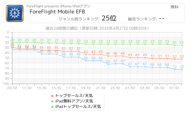
| 順位 |
| |||
| リリース日 | 2009-12-17 02:38:35 | 評価 |
|
|
| 互換性 | iOS 16.0以降が必要です。 iPhone、iPad および iPod touch 対応。 | |||
|
||||
 (12人)
(12人)
Download for a 30-day free trial. ForeFlight is the essential, integrated flight app that makes planning, flying, and logging flights a joy.
ForeFlight delivers advanced flight planning capabilities, terminal procedure charts, enroute navigation charts, moving map, synthetic vision, hazard awareness, optional Jeppesen charts, a comprehensive library of market-leading weather information and visualization features, a large library of advanced aircraft performance profiles, customizable checklists, integration with a wide range of certified avionics and portable ADS-B and GPS receivers for inflight weather and data, a built-in documents catalog and cloud document capability for management of aircraft and flight operations publications, an easy-to-use pilot logbook for keeping track of flight experience, and so much more. ForeFlight is backed by our Pilot Support Team who delivers amazingly fast, accurate, and friendly customer service.
Please note: Location is used to enable a moving map and to record track logs, the camera is used to attach photos to logbook, push notifications are used for important bulletins and flight alerts, and contacts are used to add people to flights.
ForeFlight requires a subscription. Visit our website for more information on the available plan levels.
FLIGHT PLANNING, BRIEFING, & FILING
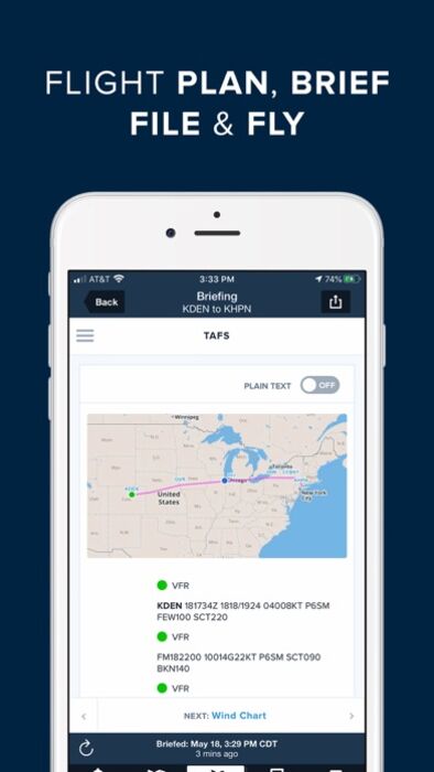
Plan flights with Touch Planning on the Map or full-featured form-based Flights view. Tap out a route in seconds and quickly see if flights will be affected by weather or TFRs. Helpful Route, Altitude, and Procedure Advisors make planning easy and accurate. Generate a graphical preflight briefing and file your flight plan directly from the app. Print a professional-grade Navlog for inflight reference.
WEATHER
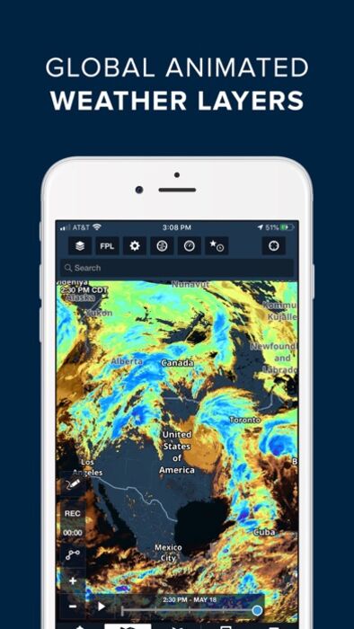
Interactive weather layers include animated radar, global satellite and winds aloft, global icing, turbulence, and surface analysis, graphical AIR/SIGMETs, flight category, visibility, and more. View decoded METARs, TAFs, and MOS forecasts. Thoughtfully organized Imagery view puts a full range of forecast tools at your fingertips.
PLATES, CHARTS, & MAPS
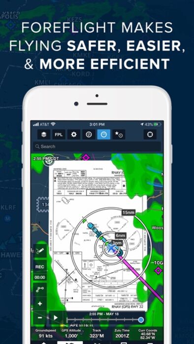
Both VFR and IFR operations are covered with all of the essentials required for planning and navigation: data-driven Aeronautical Maps, VFR Sectionals, High/Low Enroute charts, SIDs, STARs, approach and taxi charts, and terrain, satellite, and street map views.
GEO-REFERENCED APPROACHES & TAXI CHARTS
Plates and taxi charts enable the real time display of your GPS location on the chart. They can also be overlaid on the Maps view along with weather and hazards for the ultimate situational awareness.
GLOBAL HAZARD AWARENESS TECHNOLOGY
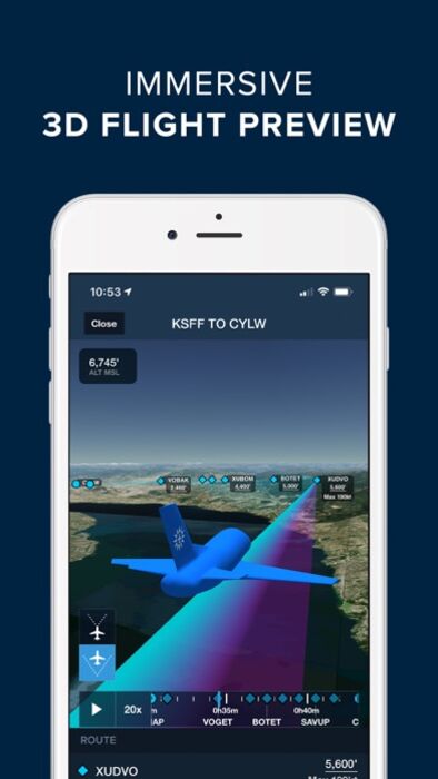
Plan and fly with more confidence in all conditions and terrain. Top-down-view Hazard Advisor map layer, Terrain Profile View, and 3D Synthetic Vision seamlessly integrate into the map display to depict a clear picture of terrain and obstacle hazards anywhere in the world. When paired with an AHRS source, Synthetic Vision provides a backup attitude display.
LOGBOOK
Logbook makes it easy to log and share flights, track hours, review currency, record certificates and ratings, receive electronic instructor endorsements, and create experience reports. Your data is automatically synced across all your devices and protected in secure cloud storage.
ADDITIONAL FEATURES INCLUDE:
Built-in documents catalog with FAR/AIM, charts supplements, and more
Airport, FBO, and fuel price information for thousands of locations
Dynamic data-driven Aeronautical Maps
Weight & Balance
Glide Advisor
Expected route and EDCT flight notifications
Automatic over-the-air data updates
Chart color inversion for better night flying experience
Access to web planner
REVIEWS
Flying Magazine Editor's Choice 2012, 2013, 2014, 2017
App of the Year, Aviation Consumer, July 2011
Best Selling iPad Aviation App: 2010, 2011, 2012
"Best app for IFR" - Aviation Consumer
"One of the most popular and most-respected aviation apps available" - Sporty's Pilot Shop
更新履歴
Discover - Events & Education
• Discover new fly-ins, new aviation communities, and new skills with the new Discover tab in More!
• Access an interactive map and list of upcoming events from AOPA and EAA in the Events tab. Filter the events list by date and type (Learn, Discover, or Gather) and tap on any event in the list or on the map to view its details.
• Access ForeFlight’s extensive video library for feature tutorials and more in the Education section. Videos are grouped into categories and playlists to make it easy to find videos on specific capabilities or areas of the ForeFlight app. Tap on each video to start playing it directly in the app and get more details from the video description below.
AI Airport Comments Summary
• Quickly learn what pilots are saying about an airport with a helpful AI-generated summary of pilot comments.
• Tap the Comments button in the top-right of an airport’s detail page to view the summary above the full list of comments.
Aeronautical Map - Waypoint Settings
• Customize which waypoints - VFR, IFR, or both - appear on the Aeronautical Map while in VFR Mode to access only the waypoints you need while decluttering the map.
• With the Aeronautical Map layer enabled and the VFR Mode selected, tap the Settings button at the bottom of the Aeronautical Map Drawer and scroll down to the new Waypoint Settings section to find separate toggles for “Fixes & RNAV” and “VFR Waypoints”.
• These toggles determine which waypoint types are enabled or disabled by the waypoint quick filter in the Aeronautical Map Drawer, allowing you to easily show only VFR waypoints, only IFR fixes and RNAV waypoints, or both using the waypoints quick filter while in VFR Mode.
U.S. LTA Documents
• Any FAA-published Letters to Airmen are now viewable in the FAA section of the Airport Procedures tab and saved for offline reference.
• Available for customers with the U.S. region as part of their subscription plan.
MFB One - ERAA Corridor
• Easily customize, calculate, and display the Emergency Route Abort Altitude and control point for a Low Level Corridor.
• Tap any route bubble in the FPL Editor and tap Low Level Corridor to enter the Low Level Corridor setup menu where you can set entry and exit fixes and customize the ERAA.
• In addition to setting the ERAA corridor width (44nm by default), you can also set both a mountainous and non-mountainous ERAA (1,000 feet and 2,000 feet respectively by default).
• Tap Apply to Route to add the Low Level Corridor to your route and display the ERAA corridor outline and ERAA control point directly on the map.
• ForeFlight also adds a badge in the bottom-right corner of the screen displaying the ERAA for quick reference, which you can tap to show or hide the ERAA corridor outline.
• Available with ForeFlight’s Military Flight Bag One subscription plan.
ForeFlight Trip Support - Services Tab
• Stay up to speed on trips and services you’ve contracted with ForeFlight’s Trip Support team directly in the app, with details on trip legs, crews and passengers, and up-to-date service status.
• ForeFlight Trip Support customers can select which of their pilots should have access to trip details and service status during the onboarding process.
• Pilots with access to the Services tab can view details for individual legs of upcoming or ongoing scheduled trips, including the assigned aircraft and crew members, passengers, and any services contracted for that leg. Tap into each service to view more information like the current status, the name of the contracted company for that service, notes provided by Trip Support staff, and more.
• Available in More > Services for ForeFlight Trip Support customers.
ForeFlight delivers advanced flight planning capabilities, terminal procedure charts, enroute navigation charts, moving map, synthetic vision, hazard awareness, optional Jeppesen charts, a comprehensive library of market-leading weather information and visualization features, a large library of advanced aircraft performance profiles, customizable checklists, integration with a wide range of certified avionics and portable ADS-B and GPS receivers for inflight weather and data, a built-in documents catalog and cloud document capability for management of aircraft and flight operations publications, an easy-to-use pilot logbook for keeping track of flight experience, and so much more. ForeFlight is backed by our Pilot Support Team who delivers amazingly fast, accurate, and friendly customer service.
Please note: Location is used to enable a moving map and to record track logs, the camera is used to attach photos to logbook, push notifications are used for important bulletins and flight alerts, and contacts are used to add people to flights.
ForeFlight requires a subscription. Visit our website for more information on the available plan levels.
FLIGHT PLANNING, BRIEFING, & FILING
Plan flights with Touch Planning on the Map or full-featured form-based Flights view. Tap out a route in seconds and quickly see if flights will be affected by weather or TFRs. Helpful Route, Altitude, and Procedure Advisors make planning easy and accurate. Generate a graphical preflight briefing and file your flight plan directly from the app. Print a professional-grade Navlog for inflight reference.
WEATHER
Interactive weather layers include animated radar, global satellite and winds aloft, global icing, turbulence, and surface analysis, graphical AIR/SIGMETs, flight category, visibility, and more. View decoded METARs, TAFs, and MOS forecasts. Thoughtfully organized Imagery view puts a full range of forecast tools at your fingertips.
PLATES, CHARTS, & MAPS
Both VFR and IFR operations are covered with all of the essentials required for planning and navigation: data-driven Aeronautical Maps, VFR Sectionals, High/Low Enroute charts, SIDs, STARs, approach and taxi charts, and terrain, satellite, and street map views.
GEO-REFERENCED APPROACHES & TAXI CHARTS
Plates and taxi charts enable the real time display of your GPS location on the chart. They can also be overlaid on the Maps view along with weather and hazards for the ultimate situational awareness.
GLOBAL HAZARD AWARENESS TECHNOLOGY
Plan and fly with more confidence in all conditions and terrain. Top-down-view Hazard Advisor map layer, Terrain Profile View, and 3D Synthetic Vision seamlessly integrate into the map display to depict a clear picture of terrain and obstacle hazards anywhere in the world. When paired with an AHRS source, Synthetic Vision provides a backup attitude display.
LOGBOOK
Logbook makes it easy to log and share flights, track hours, review currency, record certificates and ratings, receive electronic instructor endorsements, and create experience reports. Your data is automatically synced across all your devices and protected in secure cloud storage.
ADDITIONAL FEATURES INCLUDE:
Built-in documents catalog with FAR/AIM, charts supplements, and more
Airport, FBO, and fuel price information for thousands of locations
Dynamic data-driven Aeronautical Maps
Weight & Balance
Glide Advisor
Expected route and EDCT flight notifications
Automatic over-the-air data updates
Chart color inversion for better night flying experience
Access to web planner
REVIEWS
Flying Magazine Editor's Choice 2012, 2013, 2014, 2017
App of the Year, Aviation Consumer, July 2011
Best Selling iPad Aviation App: 2010, 2011, 2012
"Best app for IFR" - Aviation Consumer
"One of the most popular and most-respected aviation apps available" - Sporty's Pilot Shop
更新履歴
Discover - Events & Education
• Discover new fly-ins, new aviation communities, and new skills with the new Discover tab in More!
• Access an interactive map and list of upcoming events from AOPA and EAA in the Events tab. Filter the events list by date and type (Learn, Discover, or Gather) and tap on any event in the list or on the map to view its details.
• Access ForeFlight’s extensive video library for feature tutorials and more in the Education section. Videos are grouped into categories and playlists to make it easy to find videos on specific capabilities or areas of the ForeFlight app. Tap on each video to start playing it directly in the app and get more details from the video description below.
AI Airport Comments Summary
• Quickly learn what pilots are saying about an airport with a helpful AI-generated summary of pilot comments.
• Tap the Comments button in the top-right of an airport’s detail page to view the summary above the full list of comments.
Aeronautical Map - Waypoint Settings
• Customize which waypoints - VFR, IFR, or both - appear on the Aeronautical Map while in VFR Mode to access only the waypoints you need while decluttering the map.
• With the Aeronautical Map layer enabled and the VFR Mode selected, tap the Settings button at the bottom of the Aeronautical Map Drawer and scroll down to the new Waypoint Settings section to find separate toggles for “Fixes & RNAV” and “VFR Waypoints”.
• These toggles determine which waypoint types are enabled or disabled by the waypoint quick filter in the Aeronautical Map Drawer, allowing you to easily show only VFR waypoints, only IFR fixes and RNAV waypoints, or both using the waypoints quick filter while in VFR Mode.
U.S. LTA Documents
• Any FAA-published Letters to Airmen are now viewable in the FAA section of the Airport Procedures tab and saved for offline reference.
• Available for customers with the U.S. region as part of their subscription plan.
MFB One - ERAA Corridor
• Easily customize, calculate, and display the Emergency Route Abort Altitude and control point for a Low Level Corridor.
• Tap any route bubble in the FPL Editor and tap Low Level Corridor to enter the Low Level Corridor setup menu where you can set entry and exit fixes and customize the ERAA.
• In addition to setting the ERAA corridor width (44nm by default), you can also set both a mountainous and non-mountainous ERAA (1,000 feet and 2,000 feet respectively by default).
• Tap Apply to Route to add the Low Level Corridor to your route and display the ERAA corridor outline and ERAA control point directly on the map.
• ForeFlight also adds a badge in the bottom-right corner of the screen displaying the ERAA for quick reference, which you can tap to show or hide the ERAA corridor outline.
• Available with ForeFlight’s Military Flight Bag One subscription plan.
ForeFlight Trip Support - Services Tab
• Stay up to speed on trips and services you’ve contracted with ForeFlight’s Trip Support team directly in the app, with details on trip legs, crews and passengers, and up-to-date service status.
• ForeFlight Trip Support customers can select which of their pilots should have access to trip details and service status during the onboarding process.
• Pilots with access to the Services tab can view details for individual legs of upcoming or ongoing scheduled trips, including the assigned aircraft and crew members, passengers, and any services contracted for that leg. Tap into each service to view more information like the current status, the name of the contracted company for that service, notes provided by Trip Support staff, and more.
• Available in More > Services for ForeFlight Trip Support customers.
ブログパーツ第二弾を公開しました!ホームページでアプリの順位・価格・周辺ランキングをご紹介頂けます。
ブログパーツ第2弾!
アプリの周辺ランキングを表示するブログパーツです。価格・順位共に自動で最新情報に更新されるのでアプリの状態チェックにも最適です。
ランキング圏外の場合でも周辺ランキングの代わりに説明文を表示にするので安心です。
サンプルが気に入りましたら、下に表示されたHTMLタグをそのままページに貼り付けることでご利用頂けます。ただし、一般公開されているページでご使用頂かないと表示されませんのでご注意ください。
幅200px版
幅320px版
お気に入りのアプリをご紹介頂くためのブログパーツです。アプリの価格や順位表示は毎日自動更新♪
サンプルが気に入りましたら、下に表示されたHTMLタグをそのままページに貼り付けることでご利用頂けます。
※配信を停止させていただく可能性もございますので、タグの改変はご遠慮ください。

Now Loading...

「iPhone & iPad アプリランキング」は、最新かつ詳細なアプリ情報をご紹介しているサイトです。
お探しのアプリに出会えるように様々な切り口でページをご用意しております。
「メニュー」よりぜひアプリ探しにお役立て下さい。
Presents by $$308413110 スマホからのアクセスにはQRコードをご活用ください。 →
Now loading...