ForeFlight Mobile EFB |
| この情報はストアのものより古い可能性がございます。 | ||||
|
|
価格 | 無料 | ダウンロード |
|
|---|---|---|---|---|
| ジャンル | 天気 | |||
サイズ | 442.3MB (ダウンロードにWIFIが必要) | |||
| 開発者 | ForeFlight | |||
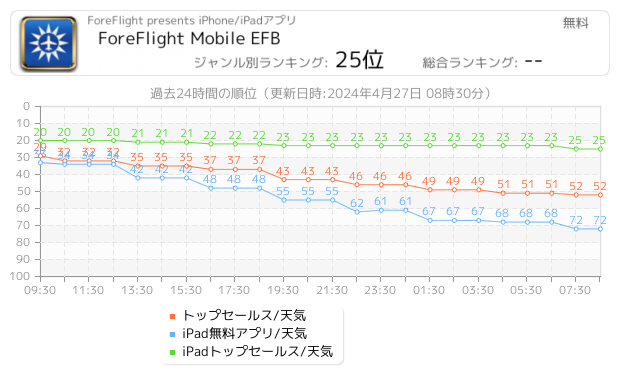
| 順位 |
| |||
| リリース日 | 2009-12-17 02:38:35 | |||
| 評価 |
|
|||
| 互換性 | iOS 16.0以降が必要です。 iPhone、iPad および iPod touch 対応。 | |||
 (15人)
(15人)
Download for a 30-day free trial of our top subscription plan! Visit our website for more information on available plans and add-ons.
ForeFlight is the leading flight app for VFR and IFR pilots everywhere, making flight planning and flying easier, safer, and more enjoyable.
FLIGHT PLANNING, BRIEFING, & FILING
Plan flights with Touch Planning on the Map or full-featured form-based Flights view. Tap out a route in seconds and quickly see if flights will be affected by weather or TFRs. Helpful Route, Altitude, and Procedure Advisors make planning easy and accurate. Generate a graphical preflight briefing and file your flight plan directly from the app. Print a professional-grade Navlog for inflight reference.
WEATHER
Interactive weather layers include animated radar, global satellite and winds aloft, global icing, turbulence, and surface analysis, graphical AIR/SIGMETs, flight category, visibility, and more. View decoded METARs, TAFs, and MOS forecasts. Thoughtfully organized Imagery view puts a full range of forecast tools at your fingertips.
PLATES, CHARTS, & MAPS
Both VFR and IFR operations are covered with all of the essentials required for planning and navigation: data-driven Aeronautical Maps, VFR Sectionals, High/Low Enroute charts, SIDs, STARs, approach and taxi charts, and terrain, satellite, and street map views.
GEO-REFERENCED APPROACHES & TAXI CHARTS
Plates and taxi charts enable the real time display of your GPS location on the chart. They can also be overlaid on the Maps view along with weather and hazards for the ultimate situational awareness.
GLOBAL HAZARD AWARENESS TECHNOLOGY
Plan and fly with more confidence in all conditions and terrain. Top-down-view Hazard Advisor map layer, Terrain Profile View, and 3D Synthetic Vision seamlessly integrate into the map display to depict a clear picture of terrain and obstacle hazards anywhere in the world. When paired with an AHRS source, Synthetic Vision provides a backup attitude display.
LOGBOOK
Logbook makes it easy to log and share flights, track hours, review currency, record certificates and ratings, receive electronic instructor endorsements, and create experience reports. Your data is automatically synced across all your devices and protected in secure cloud storage.
ADDITIONAL FEATURES INCLUDE:
Built-in documents catalog with FAR/AIM, charts supplements, and more
Airport, FBO, and fuel price information for thousands of locations
Dynamic data-driven Aeronautical Maps
Weight & Balance
Glide Advisor
Automatic chart and data data updates
Chart color inversion for better night flying experience
Access to web planner
更新履歴
Improvements and fixes for the new year
• This release includes performance improvements and bug fixes; just some routine maintenance to keep you cruising at peak efficiency


Now Loading...

「iPhone & iPad アプリランキング」は、最新かつ詳細なアプリ情報をご紹介しているサイトです。
お探しのアプリに出会えるように様々な切り口でページをご用意しております。
「メニュー」よりぜひアプリ探しにお役立て下さい。
Presents by $$308413110 スマホからのアクセスにはQRコードをご活用ください。 →
Now loading...