Bluefield Incidents |
| このアプリは現在ストアで閲覧することができません。 | ||||

|
価格 | 無料 | ダウンロード |
|
|---|---|---|---|---|
| ジャンル | ナビゲーション | |||
サイズ | 78.8MB | |||
| 開発者 | Bluefield GIS, Inc. | |||
| 順位 |
| |||
| リリース日 | 2021-12-20 17:00:00 | 評価 | 評価が取得できませんでした。 | |
| 互換性 | iOS 13.0以降が必要です。 iPhone、iPad および iPod touch 対応。 | |||
|
||||
Bluefield Incidents makes your emergency team on the ground as responsive as possible when seconds count.
Bluefield Incidents for ArcGIS gives you the same simple drawing and note-taking capabilities found in our popular app, Draw Maps for ArcGIS. Bluefield Incidents adds functionality specific to emergency management and incident management settings. For a new incident, staff members on the scene can make notes on the map which are shared with each other automatically as the notes are being made, map notes synchronized in near real time (multi-user notes). This can assist the team in numerous ways during an emergency while also making a permanent record in ArcGIS tied to the incident number.
Bluefield Incidents also serves as a great reporting mechanism. Send copies of the map to anyone with Draw Maps (either Draw Maps: Map Notes or Draw Maps for ArcGIS, both of which are free downloads on the App Store). Alternatively, send copies in KML format to anyone with Google Earth.
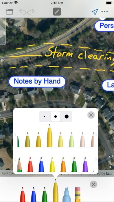
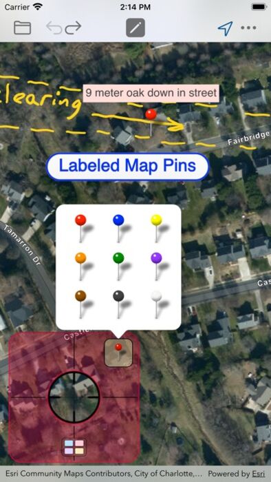
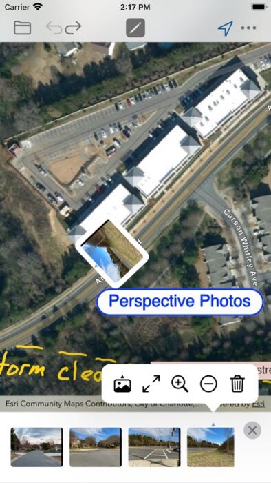
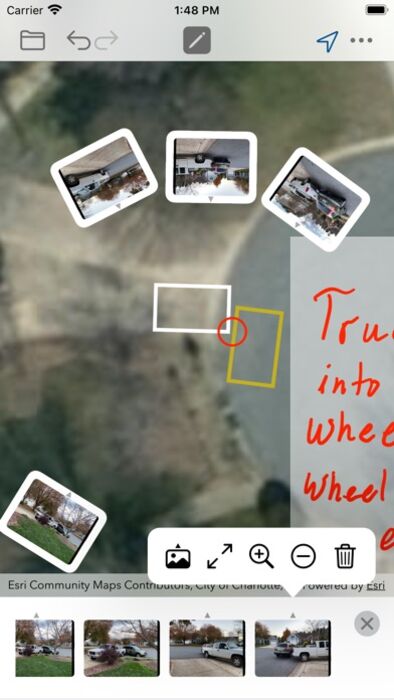
Bluefield Incidents gives you color pens and pencils to make sketches and take notes anywhere in the map. Add photos from different angles of the incident scene showing multiple perspectives. Take notes on each photo similar to the way notes are taken in the map. Add map pins to show important locations. Move around and zoom to different scales as you draw.
Your notes and photos are instantly viewable in ArcGIS Online. A web app can easily be setup in ArcGIS Online to show notes during an active incident in progress.
Features:
- Join new incidents while in the field
- Create new incidents if needed
- Draw and highlight in the map
- Place colored map pins in the map and add long form notes
- Place photos in the map
- Draw and highlight in the photos
- 72 colors
- Use the stencil to draw perfect shapes or labels
- Move and zoom the map as needed while you draw
- Works great with Apple Pencil
- Take your maps offline with Map Package Download
- Send images of your map drawings to other people
- Send copies as Draw Maps Documents to Draw Maps users
- Send KML
Common use cases:
- Traffic accidents
- Plane crashes
- Train derailments
- Structure fires
- Forest fires
- Storm damage
- Natural disasters
- Missing persons
- Crime scenes
- Property damage
- Graffiti and vandalism
- Insurance investigations
- Fire inspections
IMPORTANT: *REQUIRES* ArcGIS Online Login.
Bluefield Incidents for ArcGIS gives you the same simple drawing and note-taking capabilities found in our popular app, Draw Maps for ArcGIS. Bluefield Incidents adds functionality specific to emergency management and incident management settings. For a new incident, staff members on the scene can make notes on the map which are shared with each other automatically as the notes are being made, map notes synchronized in near real time (multi-user notes). This can assist the team in numerous ways during an emergency while also making a permanent record in ArcGIS tied to the incident number.
Bluefield Incidents also serves as a great reporting mechanism. Send copies of the map to anyone with Draw Maps (either Draw Maps: Map Notes or Draw Maps for ArcGIS, both of which are free downloads on the App Store). Alternatively, send copies in KML format to anyone with Google Earth.
Bluefield Incidents gives you color pens and pencils to make sketches and take notes anywhere in the map. Add photos from different angles of the incident scene showing multiple perspectives. Take notes on each photo similar to the way notes are taken in the map. Add map pins to show important locations. Move around and zoom to different scales as you draw.
Your notes and photos are instantly viewable in ArcGIS Online. A web app can easily be setup in ArcGIS Online to show notes during an active incident in progress.
Features:
- Join new incidents while in the field
- Create new incidents if needed
- Draw and highlight in the map
- Place colored map pins in the map and add long form notes
- Place photos in the map
- Draw and highlight in the photos
- 72 colors
- Use the stencil to draw perfect shapes or labels
- Move and zoom the map as needed while you draw
- Works great with Apple Pencil
- Take your maps offline with Map Package Download
- Send images of your map drawings to other people
- Send copies as Draw Maps Documents to Draw Maps users
- Send KML
Common use cases:
- Traffic accidents
- Plane crashes
- Train derailments
- Structure fires
- Forest fires
- Storm damage
- Natural disasters
- Missing persons
- Crime scenes
- Property damage
- Graffiti and vandalism
- Insurance investigations
- Fire inspections
IMPORTANT: *REQUIRES* ArcGIS Online Login.
ブログパーツ第二弾を公開しました!ホームページでアプリの順位・価格・周辺ランキングをご紹介頂けます。
ブログパーツ第2弾!
アプリの周辺ランキングを表示するブログパーツです。価格・順位共に自動で最新情報に更新されるのでアプリの状態チェックにも最適です。
ランキング圏外の場合でも周辺ランキングの代わりに説明文を表示にするので安心です。
サンプルが気に入りましたら、下に表示されたHTMLタグをそのままページに貼り付けることでご利用頂けます。ただし、一般公開されているページでご使用頂かないと表示されませんのでご注意ください。
幅200px版
幅320px版
お気に入りのアプリをご紹介頂くためのブログパーツです。アプリの価格や順位表示は毎日自動更新♪
サンプルが気に入りましたら、下に表示されたHTMLタグをそのままページに貼り付けることでご利用頂けます。
※配信を停止させていただく可能性もございますので、タグの改変はご遠慮ください。

Now Loading...

「iPhone & iPad アプリランキング」は、最新かつ詳細なアプリ情報をご紹介しているサイトです。
お探しのアプリに出会えるように様々な切り口でページをご用意しております。
「メニュー」よりぜひアプリ探しにお役立て下さい。
Presents by $$308413110 スマホからのアクセスにはQRコードをご活用ください。 →
Now loading...