Radar MAX Future Weather Radar |


|
価格 | 無料 | ダウンロード |
|
|---|---|---|---|---|
| ジャンル | 天気 | |||
サイズ | 64.7MB | |||
| 開発者 | Elecont LLC | |||
| 順位 |
| |||
| リリース日 | 2021-04-05 16:00:00 | 評価 | 評価が取得できませんでした。 | |
| 互換性 | iOS 11.0以降が必要です。 iPhone、iPad および iPod touch 対応。 | |||
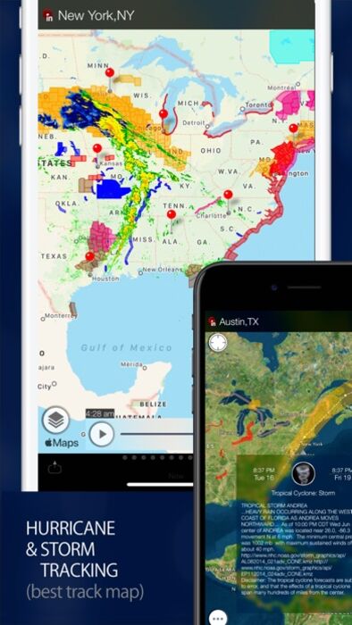
Free. Fast. Simple. Predictive high-resolution Weather Radar. Severe weather warnings. Storm tracks and future projections. Satellite cloud animation. Use Radar MAX to see what weather is coming your way!
Radar shows areas of current precipitation or future simulated radar prediction!. A weather radar is used to locate precipitation, calculate its motion, estimate its type (rain, snow, hail, etc.), and forecast its future position and intensity. Precipitation type is indicated by the color. Green color indicates lesser precipitation while the yellow color code indicates intense precipitations. The color code red is indicative of the most intense precipitations. Blue color indicates snow.
Using the data from Storm Prediction Center and Global Disaster Alert and Coordination System (SPC & GDAC) Radar MAX provides information about tropical storms and hurricanes for locations worldwide, areas affected by storms and severe weather, coordinates and wind speed, storm tracks & path projections.
Satellite images provide an excellent view on the clouds in the sky and an indication of the weather over the United states, Europe, Japan, Australia and Indonesia.
Satellite images come from satellites which remain above a fixed point on the Earth (i.e. they are “geostationary”). Lighter areas of cloud show where the cloud tops are cooler and therefore where weather features like fronts and shower clouds are.
The app also allows you to check the weather on your favorite places on maps. Interactive map includes live international weather conditions, local weather and time, ten-day forecasts and sunrise/sunset times for multiple places. You can add placemarks on the map to represent your favorite places or the places you’d like to visit. At a glance you can see the time and weather for all of your favorites.
Key features:
* [NEW] Predictive weather radar
* [NEW] Simulated radar prediction for the next 60 minutes using five-minute intervals
* The real time radar images provided by NEXRAD an accurate view of the weather situation in the U.S.
* Storm / hurricane / typhoon tracker and projected paths (International and Global)
* All severe weather alerts on interactive map, 126 weather alert types (U.S.)
* High resolution weather radar. Stunning and sharp images. (U.S.)
* Animated satellite images of cloud cover (U.S., E.U., Japan, Australia)
* Current weather conditions directly on the map. 130,000 locations worldwide.
* Current weather details and ten-day forecast in pop-up window.
Features include:
* three different layers to get the weather: ground stations, radar and satellite.
* zoom in and out, drag and scroll
* play, pause animations at any zoom level
* displays current position on the map
* saves and restores your last position
* adjustable radar image quality for Wi-Fi and cellular connections
更新履歴
Bug fixes and performance improvements
ブログパーツ第二弾を公開しました!ホームページでアプリの順位・価格・周辺ランキングをご紹介頂けます。
ブログパーツ第2弾!
アプリの周辺ランキングを表示するブログパーツです。価格・順位共に自動で最新情報に更新されるのでアプリの状態チェックにも最適です。
ランキング圏外の場合でも周辺ランキングの代わりに説明文を表示にするので安心です。
サンプルが気に入りましたら、下に表示されたHTMLタグをそのままページに貼り付けることでご利用頂けます。ただし、一般公開されているページでご使用頂かないと表示されませんのでご注意ください。
幅200px版
幅320px版
お気に入りのアプリをご紹介頂くためのブログパーツです。アプリの価格や順位表示は毎日自動更新♪
サンプルが気に入りましたら、下に表示されたHTMLタグをそのままページに貼り付けることでご利用頂けます。
※配信を停止させていただく可能性もございますので、タグの改変はご遠慮ください。

Now Loading...

「iPhone & iPad アプリランキング」は、最新かつ詳細なアプリ情報をご紹介しているサイトです。
お探しのアプリに出会えるように様々な切り口でページをご用意しております。
「メニュー」よりぜひアプリ探しにお役立て下さい。
Presents by $$308413110 スマホからのアクセスにはQRコードをご活用ください。 →
Now loading...