Hikepack: Clever Hiking Maps |
| このアプリは現在ストアで閲覧することができません。 | ||||
|
価格 | 無料 | ダウンロード |
|
|---|---|---|---|---|
| ジャンル | ナビゲーション | |||
サイズ | 34.3MB | |||
| 開発者 | Alexandru Ioan Tomescu | |||
| 順位 |
| |||
| リリース日 | 2018-05-04 05:47:05 | 評価 | 評価が取得できませんでした。 | |
| 互換性 | iOS 9.0以降が必要です。 iPhone、iPad および iPod touch 対応。 | |||
|
||||
Plan ahead, stay on track, explore. Satellite & topo maps, trails, elevations, route planning and navigation. OFFLINE, with just one tap.
ONLY IN HIKEPACK, ALL OFFLINE:
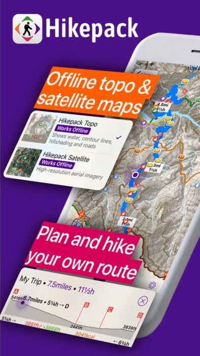
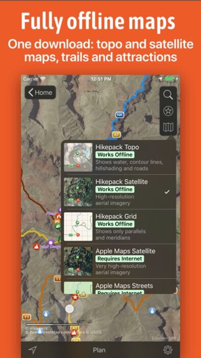
• One download: Trails, peaks and attractions with topo and satellite imagery covering the ENTIRE map.*
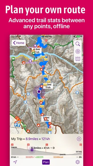
• Planning along trails: Plan your own custom route along existing map trails by simply dropping pins on the map.
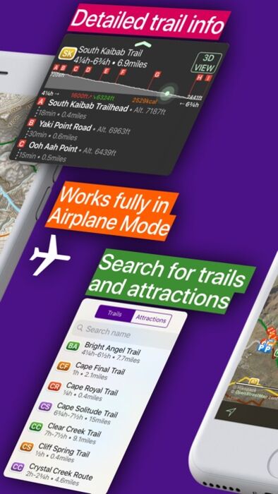
• GPS Navigation: Time, distance, elevation profiles, total ascent, descent, and calories.
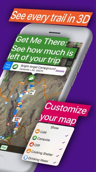
• Get Me There: While hiking, see the remaining time, distance and route to any map symbol or to any dropped pin.
PLAN YOUR TRIP
• See elevation profiles and other advanced trail stats (length, hiking time, ascent/descent, calories)
• Plan your own route, and see the same advanced trail stats also for it
• See the altitude of any point on any route
WHILE YOU HIKE
• See the remaining time and distance to any location, and find the shortest route to it
• See your location on the map
FEATURES IN DETAIL
• Hikepack intelligently extracts all hiking, biking and cross-country ski trails and points of interest from OpenStreetMap data, and packs them into one download. So you have a curated map focused on outdoor activities.
• The topographic and satellite map layers are created by Hikepack, from open data.* They cover the ENTIRE map, which means you're never lost. This is made possible by our proprietary compression algorithms, that allow for a small download and a smooth experience.
• All the routing is done on your device. So if you're in the middle of a hike and without cellular signal, you still see the remaining hiking time and distance to your destination.
• You can save the routes you planned in one map, and then compare their elevation profiles at a glance.
• You can change the hiking speed used for computing hiking time estimates.
• You can filter what points of interest you see on the map.
• You can measure distances in a straight line, between any points, but they will not take the terrain into account.
••• You can download as many maps as you wish for free offline use, but some features require a Pro Pass subscription.
We're just getting started, and we'd love to hear from you! Suggest new maps or features by sending an e-mail to hello@hikepack.earth, or using the Feedback form in the app.
We regularly publish new maps in Hikepack. Currently, we cover all US national parks: Grand Canyon, Great Smoky, Yosemite, Zion, Rocky Mountain, Yellowstone, Olympic, Acadia, Grand Teton, Glacier, Joshua Tree, Cuyahoga Valley, Bryce Canyon, Hawai'i Volcanoes, Arches, Hot Springs, Shenandoah, Mount Rainier, Death Valley, Haleakala, Sequoia, Capitol Reef, Badlands, Everglades, Saguaro East, Saguaro West, Canyonlands, Crater Lake, Theodore Roosevelt, Petrified Forest, Wind Cave, Kings Canyon, Mammoth Cave, Mesa Verde, Redwood, Lassen Volcanic, Glacier Bay, Carlsbad Caverns, Virgin Islands, Great Sand Dunes, Big Bend, Channel Islands, Kenai Fjords, Voyageurs, Black Canyon of the Gunnison, Pinnacles, Guadalupe Mountains, Great Basin, Congaree, Katmai, North Cascades.
We also cover 40 US national forests, and many other parks, all UK national parks, 35 maps in Finland covering the main hiking areas, from the northern-most parts of Lapland, to popular parks near Helsinki, and 37 maps in Romania covering most of the Carpathian mountains.
----------
* Satellite imagery available only for selected maps in the US and Finland only. The topo layer available for all maps.
** The maps are created by Hikepack from open data. See the details page of each map for the copyright holders.
更新履歴
This update fixes several bugs and issues, including those with submitting feedback or requests for new maps.
ONLY IN HIKEPACK, ALL OFFLINE:
• One download: Trails, peaks and attractions with topo and satellite imagery covering the ENTIRE map.*
• Planning along trails: Plan your own custom route along existing map trails by simply dropping pins on the map.
• GPS Navigation: Time, distance, elevation profiles, total ascent, descent, and calories.
• Get Me There: While hiking, see the remaining time, distance and route to any map symbol or to any dropped pin.
PLAN YOUR TRIP
• See elevation profiles and other advanced trail stats (length, hiking time, ascent/descent, calories)
• Plan your own route, and see the same advanced trail stats also for it
• See the altitude of any point on any route
WHILE YOU HIKE
• See the remaining time and distance to any location, and find the shortest route to it
• See your location on the map
FEATURES IN DETAIL
• Hikepack intelligently extracts all hiking, biking and cross-country ski trails and points of interest from OpenStreetMap data, and packs them into one download. So you have a curated map focused on outdoor activities.
• The topographic and satellite map layers are created by Hikepack, from open data.* They cover the ENTIRE map, which means you're never lost. This is made possible by our proprietary compression algorithms, that allow for a small download and a smooth experience.
• All the routing is done on your device. So if you're in the middle of a hike and without cellular signal, you still see the remaining hiking time and distance to your destination.
• You can save the routes you planned in one map, and then compare their elevation profiles at a glance.
• You can change the hiking speed used for computing hiking time estimates.
• You can filter what points of interest you see on the map.
• You can measure distances in a straight line, between any points, but they will not take the terrain into account.
••• You can download as many maps as you wish for free offline use, but some features require a Pro Pass subscription.
We're just getting started, and we'd love to hear from you! Suggest new maps or features by sending an e-mail to hello@hikepack.earth, or using the Feedback form in the app.
We regularly publish new maps in Hikepack. Currently, we cover all US national parks: Grand Canyon, Great Smoky, Yosemite, Zion, Rocky Mountain, Yellowstone, Olympic, Acadia, Grand Teton, Glacier, Joshua Tree, Cuyahoga Valley, Bryce Canyon, Hawai'i Volcanoes, Arches, Hot Springs, Shenandoah, Mount Rainier, Death Valley, Haleakala, Sequoia, Capitol Reef, Badlands, Everglades, Saguaro East, Saguaro West, Canyonlands, Crater Lake, Theodore Roosevelt, Petrified Forest, Wind Cave, Kings Canyon, Mammoth Cave, Mesa Verde, Redwood, Lassen Volcanic, Glacier Bay, Carlsbad Caverns, Virgin Islands, Great Sand Dunes, Big Bend, Channel Islands, Kenai Fjords, Voyageurs, Black Canyon of the Gunnison, Pinnacles, Guadalupe Mountains, Great Basin, Congaree, Katmai, North Cascades.
We also cover 40 US national forests, and many other parks, all UK national parks, 35 maps in Finland covering the main hiking areas, from the northern-most parts of Lapland, to popular parks near Helsinki, and 37 maps in Romania covering most of the Carpathian mountains.
----------
* Satellite imagery available only for selected maps in the US and Finland only. The topo layer available for all maps.
** The maps are created by Hikepack from open data. See the details page of each map for the copyright holders.
更新履歴
This update fixes several bugs and issues, including those with submitting feedback or requests for new maps.
ブログパーツ第二弾を公開しました!ホームページでアプリの順位・価格・周辺ランキングをご紹介頂けます。
ブログパーツ第2弾!
アプリの周辺ランキングを表示するブログパーツです。価格・順位共に自動で最新情報に更新されるのでアプリの状態チェックにも最適です。
ランキング圏外の場合でも周辺ランキングの代わりに説明文を表示にするので安心です。
サンプルが気に入りましたら、下に表示されたHTMLタグをそのままページに貼り付けることでご利用頂けます。ただし、一般公開されているページでご使用頂かないと表示されませんのでご注意ください。
幅200px版
幅320px版
お気に入りのアプリをご紹介頂くためのブログパーツです。アプリの価格や順位表示は毎日自動更新♪
サンプルが気に入りましたら、下に表示されたHTMLタグをそのままページに貼り付けることでご利用頂けます。
※配信を停止させていただく可能性もございますので、タグの改変はご遠慮ください。

Now Loading...

「iPhone & iPad アプリランキング」は、最新かつ詳細なアプリ情報をご紹介しているサイトです。
お探しのアプリに出会えるように様々な切り口でページをご用意しております。
「メニュー」よりぜひアプリ探しにお役立て下さい。
Presents by $$308413110 スマホからのアクセスにはQRコードをご活用ください。 →
Now loading...