Washington Pocket Maps |


|
価格 | 無料 | ダウンロード |
|
|---|---|---|---|---|
| ジャンル | 旅行 | |||
サイズ | 86.3MB | |||
| 開発者 | Alex Gugel | |||
| 順位 |
| |||
| リリース日 | 2020-04-08 16:00:00 | 評価 | 評価が取得できませんでした。 | |
| 互換性 | iOS 15.0以降が必要です。 iPhone、iPad および iPod touch 対応。 | |||
Be prepared! Plan your next trip to one of the great Washington parks. Download maps and guides before you venture into the Wi-Fi free wilderness.
Discover
- 90+ national parks, state parks, monuments, forests
- 180+ neatly folded maps by the National Park Service, Bureau of Land Management, United States Forest Services, and other agencies.
- Motor Vehicle Use Maps (MVUM), Motor Vehicle Travel Maps (MVTM) and visitor maps for Texas national forests.
- 1,700+ campgrounds and campsites
- 2,800+ trails and trailheads
- 58,000+ points of interests
Plan
- Download maps, park brochures, and newspapers. These downloads are ready when you are offline and off the grid in the great outdoors.
- Download arbitrary map sections as offline packs.
- Photo galleries, panorama views.
- Share links to parks and maps with friends
Have fun
- GPS and GPX support: record your hikes, import GPX routes, tracks and waypoints for your hiking trails.
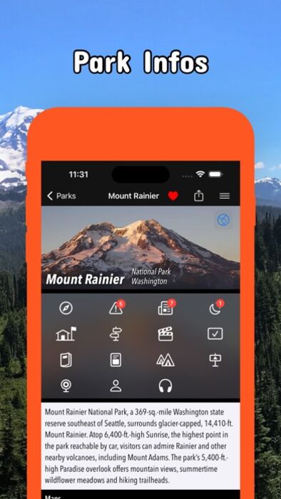
- Detailed national park information: alerts, news, visitor centers, campgrounds, driving directions, weather.
- Open your favorite maps app to get a route to the selected park.
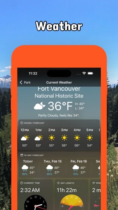
- Current weather conditions, easy access to multi-day forecasts, sunrise and sunset times.
- Push notifications for park alerts, park news, weather warnings
So download maps and guides for:
Chopaka Lake and Chopaka Mountain
Columbia River Gorge
Colville
Ebey's Landing
Fort Vancouver
Gifford Pinchot
Goat Rocks
Idaho Panhandle
Klondike Gold Rush
Lake Chelan
Lake Roosevelt
Lewis & Clark
Minidoka
Mount Adams
Mount Rainier
Mount St Helens
Mt. Baker-Snoqualmie
Nez Perce
North Cascades
Okanogan
Olympic
Ross Lake
San Juan Island
Wenatchee
Whitman Mission
There are additional useful maps and brochures for many Washington state parks, Sno-Parks and mountain bike areas like
Ahtanum, Albian Hill, Alpine Baldy, Blanchard, Blewett Pass, Bonaparte, Boulder Cave, Canyon Creek, Capitol, Cherry Valley, Clear Lake, Cougar, Crystal Springs, Deer Creek Nordic, Dockton, Duthie Hill, Echo Ridge, Elbe Hills and Tahoma, Elk Heights, Fishtrap, Green Mountain and Tahuya, Henry's Ridge, Kachess Ridge, Liberty, Middle Fork Snoqualmie, North Fork Chewelah Creek, North Mountain, Palmer Mountain and Split Rock, Paradise Valley, Raging River, Summit Ridge, Swan Creek, Teanaway, Twenty-Five Mile Creek, Twin Lakes, Walker Valley, Yacolt Burn
- FULL ACCESS is available for a for $3.49/three month (after a free 3-days trial period) or $2.49/two months or $7.49/year. You can subscribe and pay through your iTunes account. The account will be charged for renewal within 24-hours prior to the end of the current period, and identify the cost of the renewal. Your subscription will automatically renew unless canceled at least 24 hours before the end of the current period. Auto-renew can be turned off anytime by going to your Account Settings in iTunes after purchase.
- Continued use of GPS running in the background can dramatically decrease battery life.
LEGAL
Terms of Use: https://www.icoat.de/pocketmaps/terms
Privacy Policy: https://www.icoat.de/pocketmaps/privacy
更新履歴
Spring 2024 Updates!
Official Data: Get the most up-to-date information from the National Park Service (NPS), Bureau of Land Management (BLM), United States Forest Service (USFS), recreation.gov and other agencies.
Discover
- 90+ national parks, state parks, monuments, forests
- 180+ neatly folded maps by the National Park Service, Bureau of Land Management, United States Forest Services, and other agencies.
- Motor Vehicle Use Maps (MVUM), Motor Vehicle Travel Maps (MVTM) and visitor maps for Texas national forests.
- 1,700+ campgrounds and campsites
- 2,800+ trails and trailheads
- 58,000+ points of interests
Plan
- Download maps, park brochures, and newspapers. These downloads are ready when you are offline and off the grid in the great outdoors.
- Download arbitrary map sections as offline packs.
- Photo galleries, panorama views.
- Share links to parks and maps with friends
Have fun
- GPS and GPX support: record your hikes, import GPX routes, tracks and waypoints for your hiking trails.
- Detailed national park information: alerts, news, visitor centers, campgrounds, driving directions, weather.
- Open your favorite maps app to get a route to the selected park.
- Current weather conditions, easy access to multi-day forecasts, sunrise and sunset times.
- Push notifications for park alerts, park news, weather warnings
So download maps and guides for:
Chopaka Lake and Chopaka Mountain
Columbia River Gorge
Colville
Ebey's Landing
Fort Vancouver
Gifford Pinchot
Goat Rocks
Idaho Panhandle
Klondike Gold Rush
Lake Chelan
Lake Roosevelt
Lewis & Clark
Minidoka
Mount Adams
Mount Rainier
Mount St Helens
Mt. Baker-Snoqualmie
Nez Perce
North Cascades
Okanogan
Olympic
Ross Lake
San Juan Island
Wenatchee
Whitman Mission
There are additional useful maps and brochures for many Washington state parks, Sno-Parks and mountain bike areas like
Ahtanum, Albian Hill, Alpine Baldy, Blanchard, Blewett Pass, Bonaparte, Boulder Cave, Canyon Creek, Capitol, Cherry Valley, Clear Lake, Cougar, Crystal Springs, Deer Creek Nordic, Dockton, Duthie Hill, Echo Ridge, Elbe Hills and Tahoma, Elk Heights, Fishtrap, Green Mountain and Tahuya, Henry's Ridge, Kachess Ridge, Liberty, Middle Fork Snoqualmie, North Fork Chewelah Creek, North Mountain, Palmer Mountain and Split Rock, Paradise Valley, Raging River, Summit Ridge, Swan Creek, Teanaway, Twenty-Five Mile Creek, Twin Lakes, Walker Valley, Yacolt Burn
- FULL ACCESS is available for a for $3.49/three month (after a free 3-days trial period) or $2.49/two months or $7.49/year. You can subscribe and pay through your iTunes account. The account will be charged for renewal within 24-hours prior to the end of the current period, and identify the cost of the renewal. Your subscription will automatically renew unless canceled at least 24 hours before the end of the current period. Auto-renew can be turned off anytime by going to your Account Settings in iTunes after purchase.
- Continued use of GPS running in the background can dramatically decrease battery life.
LEGAL
Terms of Use: https://www.icoat.de/pocketmaps/terms
Privacy Policy: https://www.icoat.de/pocketmaps/privacy
更新履歴
Spring 2024 Updates!
Official Data: Get the most up-to-date information from the National Park Service (NPS), Bureau of Land Management (BLM), United States Forest Service (USFS), recreation.gov and other agencies.
ブログパーツ第二弾を公開しました!ホームページでアプリの順位・価格・周辺ランキングをご紹介頂けます。
ブログパーツ第2弾!
アプリの周辺ランキングを表示するブログパーツです。価格・順位共に自動で最新情報に更新されるのでアプリの状態チェックにも最適です。
ランキング圏外の場合でも周辺ランキングの代わりに説明文を表示にするので安心です。
サンプルが気に入りましたら、下に表示されたHTMLタグをそのままページに貼り付けることでご利用頂けます。ただし、一般公開されているページでご使用頂かないと表示されませんのでご注意ください。
幅200px版
幅320px版
お気に入りのアプリをご紹介頂くためのブログパーツです。アプリの価格や順位表示は毎日自動更新♪
サンプルが気に入りましたら、下に表示されたHTMLタグをそのままページに貼り付けることでご利用頂けます。
※配信を停止させていただく可能性もございますので、タグの改変はご遠慮ください。

Now Loading...

「iPhone & iPad アプリランキング」は、最新かつ詳細なアプリ情報をご紹介しているサイトです。
お探しのアプリに出会えるように様々な切り口でページをご用意しております。
「メニュー」よりぜひアプリ探しにお役立て下さい。
Presents by $$308413110 スマホからのアクセスにはQRコードをご活用ください。 →
Now loading...