Utah Pocket Maps |


|
価格 | 無料 | ダウンロード |
|
|---|---|---|---|---|
| ジャンル | 旅行 | |||
サイズ | 87.4MB | |||
| 開発者 | Alex Gugel | |||
| 順位 |
| |||
| リリース日 | 2017-10-08 08:32:43 | 評価 | 評価が取得できませんでした。 | |
| 互換性 | iOS 15.0以降が必要です。 iPhone、iPad および iPod touch 対応。 | |||
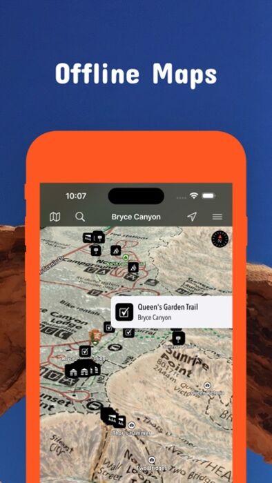
Be prepared! Plan your next trip to one of the great Utah parks. Download maps and guides before you venture into the Wi-Fi free wilderness.
- 120+ national parks, state parks, monuments, forests
- 180+ neatly folded maps by the National Park Service, Bureau of Land Management, United States Forest Services, and other agencies.
- Motor Vehicle Use Maps (MVUM), Motor Vehicle Travel Maps (MVTM) and visitor maps for Utah national forests.
- 4,100+ campgrounds and campsites
- 2,300+ trails and trailheads
- 41,000+ points of interests
Plan
- Download maps, park brochures, and newspapers. These downloads are ready when you are offline and off the grid in the great outdoors.
- Download arbitrary map sections as offline packs.
- Photo galleries, panorama views.
- Share links to parks and maps with friends
Have fun
- GPS and GPX support: record your hikes, import GPX routes, tracks and waypoints for your hiking trails.
- Detailed national park information: alerts, news, visitor centers, campgrounds, driving directions, weather.
- Open your favorite maps app to get a route to the selected park.
- Current weather conditions, easy access to multi-day forecasts, sunrise and sunset times.
- Push notifications for park alerts, park news, weather warnings
So download maps and guides for:
Arches
Bear Ears
Beaver Dam Wash
Bonneville Salt Flats
Bryce Canyon
Burbank Hills
Camp Floyd
Canyonlands
Canyonlands Field
7 Mile Rim Jeep Trail
Klondike Bluffs
Klonzo and Moab Brands
Labyrinth Rims
Mill Canyon Area Designated Route
Capitol Reef
Fremont River
Wayne County West
Cedar Breaks
Cedar City
Colorado Riverways
Amphitheater Loop and Fisher Towers Hiking Trails
Porcupine Rim Mountain Bike Trail
The Moab Daily
Utah Rims Designated Route Map
Conger Mountain
Crack Canyon
Cricket Mountains
Dixie
Escalante
Pine Valley
Powell
Fiddler Butte
Fishlake
Frontier Homestead
Thunderbird Canyon and Iron Hills Trails
Dinosaur
Factory Butte
Fantasy Canyon
Fishlake
Glen Canyon
North Wash
Goblin Valley
Golden Spike / Transcontinental Railroad
Gooseberry Mesa
Goosenecks
San Juan River
Grand Staircase-Escalante
Burr Trail Scenic Backway and Wolverine Loop Road
Cottonwood Road Scenic Backway
Hole-in-the-Rock Scenic Backway
Monument Travel Map
Skutumpah \/ Johnson Canyon Roads
Green River
Gunlock
Horseshoe Canyon (South)
Kanab
Kodachrome Basin
Little Saharah
Manti-La Sal
Millsite
Sevier County
Moab
Amasa Back Area Mountain Bike Trails
BLM Moab Camping
Chicken Corners Jeep Trail
Gemini Bridges and Long Canyon
Poison Spider Mesa
Slickrock Bike Trail
Steel Bender Jeep Safari Route
Monticello Travel Plans
Moonshine Arch
Mount Pennell
Henry Mountains
Natural Bridges
Otter Creek
Palisade
Piute County
Pony Express Trail
Price
Red Cliffs
Red Fleet
Robber Roost
San Rafael Swell
Sand Hollow
Sanpete
Salt Lake City
Sawtooth
Sevier
Smithsonian Butte National Back Country Byway
Snow Canyon
Territorial Statehouse
Three Peaks
Valley of the Gods
Vernal
McCoy Flats
Moonshine Arch
West Wayne
Zion
There are additional useful information and brochures for many Utah state parks.
- FULL ACCESS is available for a for $3.49/three month (after a free 3-days trial period) or $2.49/two months or $7.49/year. You can subscribe and pay through your iTunes account. The account will be charged for renewal within 24-hours prior to the end of the current period, and identify the cost of the renewal. Your subscription will automatically renew unless canceled at least 24 hours before the end of the current period. Auto-renew can be turned off anytime by going to your Account Settings in iTunes after purchase.
- Continued use of GPS running in the background can dramatically decrease battery life.
LEGAL
Terms of Use: https://www.icoat.de/pocketmaps/terms
Privacy Policy: https://www.icoat.de/pocketmaps/privacy
更新履歴
Spring 2024 Updates!
• Official Data: Get the most up-to-date information from the National Park Service (NPS), Bureau of Land Management (BLM), United States Forest Service (USFS), recreation.gov and other agencies.
ブログパーツ第二弾を公開しました!ホームページでアプリの順位・価格・周辺ランキングをご紹介頂けます。
ブログパーツ第2弾!
アプリの周辺ランキングを表示するブログパーツです。価格・順位共に自動で最新情報に更新されるのでアプリの状態チェックにも最適です。
ランキング圏外の場合でも周辺ランキングの代わりに説明文を表示にするので安心です。
サンプルが気に入りましたら、下に表示されたHTMLタグをそのままページに貼り付けることでご利用頂けます。ただし、一般公開されているページでご使用頂かないと表示されませんのでご注意ください。
幅200px版
幅320px版
お気に入りのアプリをご紹介頂くためのブログパーツです。アプリの価格や順位表示は毎日自動更新♪
サンプルが気に入りましたら、下に表示されたHTMLタグをそのままページに貼り付けることでご利用頂けます。
※配信を停止させていただく可能性もございますので、タグの改変はご遠慮ください。

Now Loading...

「iPhone & iPad アプリランキング」は、最新かつ詳細なアプリ情報をご紹介しているサイトです。
お探しのアプリに出会えるように様々な切り口でページをご用意しております。
「メニュー」よりぜひアプリ探しにお役立て下さい。
Presents by $$308413110 スマホからのアクセスにはQRコードをご活用ください。 →
Now loading...