Japan Alps Hiking Map |
| この情報はストアのものより古い可能性がございます。 | ||||


|
価格 | 無料 | ダウンロード |
|
|---|---|---|---|---|
| ジャンル | スポーツ | |||
サイズ | 30.0MB | |||
| 開発者 | YAMARECO INC. | |||
| 順位 |
| |||
| リリース日 | 2017-08-10 07:55:43 | 評価 |
|
|
| 互換性 | iOS 14.0以降が必要です。 iPhone、iPad および iPod touch 対応。 | |||
 (7人)
(7人)
Japan Alps Hiking Map is a map application that can be used as a hiking / outdoor GPS.
By downloading data such as maps, routes, and place names that you planned in advance, you can check your current location with GPS even if you are in a no cellular signal area like mountains.
You can use the app when you do walking, running, cycling, trip, sightseeing, or any outdoor activities in Japan.
You can also read articles about hiking know-how in Japan, and hiking guides about Mt. Fuji, Kamakura Alps, and Karasawa. We are still working to add new articles and hiking guides.
[Characteristics]
1) You can use the map offline
You can download and use the contour map of Japan which is offered by the Geospatial Information Authority of Japan.
In addition, "Footprints" which is the group of other hiker's GPS log will be displayed, so you can see at a glance where the people are actually walking (where the mountain path is).
Of course, since the place name data in English also will be downloaded, you can see the names of mountains and passes not on the contour map.
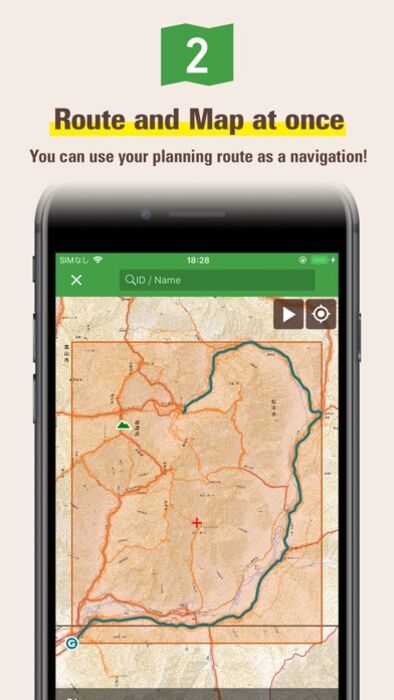
2) You can download route and map
You can download not only pre-prepared area maps but also our recommended routes and maps together.
You can also download routes and maps from a GPX file which you can get from any outdoor SNS like Yamareco.com.
3) Store GPS logs while hiking
Once you start hiking, your phone will store the current location history as a GPS log.
GPS feature is only required the sky is open, so you can get current locations even if your phone is in Airplane Mode or you are in out of a cellular signal area.
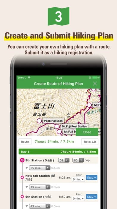
4) Your plan will be a hiking registration
You can submit your plan to Compass which is a hiking registration service in Japan.
If you register your plan into Compass, the information will be shared with the police force which has rescue teams. Please refer to Compass homepage for details.
5) Off route alert
The app will let you know by voice when you go too far off the planned route.
In addition, you can use a speech function that announces the current time and altitude periodically by voice.
[Important Notice]
Continued use of GPS running in the background can dramatically decrease battery life.
When hiking please be sure to bring a paper map and compass, spare battery and power cable.
You need to purchase a ticket to download maps for offline use. Even if you do not have a ticket, you can try all of the other functions such as GPS logging or online use.
"Footprints" function displays the actual walking traces for other hikers, but we cannot guarantees that the information is always accurate because it may include climbing routes, trails closed by the seasons, abolished roads etc.
When planning for mountain hiking, please be sure to check the latest information through other Web sites like Yamareco.com and local affiliates.
Place name data will be download after the installation. It may take around ten minutes to finish. You need to wait for download completion if you want to show all of the place name data in your map.
更新履歴
Version 1.11
- Fixed a bug that caused failure when importing a GPX file.
By downloading data such as maps, routes, and place names that you planned in advance, you can check your current location with GPS even if you are in a no cellular signal area like mountains.
You can use the app when you do walking, running, cycling, trip, sightseeing, or any outdoor activities in Japan.
You can also read articles about hiking know-how in Japan, and hiking guides about Mt. Fuji, Kamakura Alps, and Karasawa. We are still working to add new articles and hiking guides.
[Characteristics]
1) You can use the map offline
You can download and use the contour map of Japan which is offered by the Geospatial Information Authority of Japan.
In addition, "Footprints" which is the group of other hiker's GPS log will be displayed, so you can see at a glance where the people are actually walking (where the mountain path is).
Of course, since the place name data in English also will be downloaded, you can see the names of mountains and passes not on the contour map.
2) You can download route and map
You can download not only pre-prepared area maps but also our recommended routes and maps together.
You can also download routes and maps from a GPX file which you can get from any outdoor SNS like Yamareco.com.
3) Store GPS logs while hiking
Once you start hiking, your phone will store the current location history as a GPS log.
GPS feature is only required the sky is open, so you can get current locations even if your phone is in Airplane Mode or you are in out of a cellular signal area.
4) Your plan will be a hiking registration
You can submit your plan to Compass which is a hiking registration service in Japan.
If you register your plan into Compass, the information will be shared with the police force which has rescue teams. Please refer to Compass homepage for details.
5) Off route alert
The app will let you know by voice when you go too far off the planned route.
In addition, you can use a speech function that announces the current time and altitude periodically by voice.
[Important Notice]
Continued use of GPS running in the background can dramatically decrease battery life.
When hiking please be sure to bring a paper map and compass, spare battery and power cable.
You need to purchase a ticket to download maps for offline use. Even if you do not have a ticket, you can try all of the other functions such as GPS logging or online use.
"Footprints" function displays the actual walking traces for other hikers, but we cannot guarantees that the information is always accurate because it may include climbing routes, trails closed by the seasons, abolished roads etc.
When planning for mountain hiking, please be sure to check the latest information through other Web sites like Yamareco.com and local affiliates.
Place name data will be download after the installation. It may take around ten minutes to finish. You need to wait for download completion if you want to show all of the place name data in your map.
更新履歴
Version 1.11
- Fixed a bug that caused failure when importing a GPX file.
ブログパーツ第二弾を公開しました!ホームページでアプリの順位・価格・周辺ランキングをご紹介頂けます。
ブログパーツ第2弾!
アプリの周辺ランキングを表示するブログパーツです。価格・順位共に自動で最新情報に更新されるのでアプリの状態チェックにも最適です。
ランキング圏外の場合でも周辺ランキングの代わりに説明文を表示にするので安心です。
サンプルが気に入りましたら、下に表示されたHTMLタグをそのままページに貼り付けることでご利用頂けます。ただし、一般公開されているページでご使用頂かないと表示されませんのでご注意ください。
幅200px版
幅320px版
お気に入りのアプリをご紹介頂くためのブログパーツです。アプリの価格や順位表示は毎日自動更新♪
サンプルが気に入りましたら、下に表示されたHTMLタグをそのままページに貼り付けることでご利用頂けます。
※配信を停止させていただく可能性もございますので、タグの改変はご遠慮ください。

Now Loading...

「iPhone & iPad アプリランキング」は、最新かつ詳細なアプリ情報をご紹介しているサイトです。
お探しのアプリに出会えるように様々な切り口でページをご用意しております。
「メニュー」よりぜひアプリ探しにお役立て下さい。
Presents by $$308413110 スマホからのアクセスにはQRコードをご活用ください。 →
Now loading...