Fishing Points - Lake Maps |


|
価格 | 無料 | ダウンロード |
|
|---|---|---|---|---|
| ジャンル | スポーツ | |||
サイズ | 49.9MB | |||
| 開発者 | Bist LLC | |||
| 順位 |
| |||
| リリース日 | 2017-03-08 03:15:36 | 評価 |
|
|
| 互換性 | iOS 8.0以降が必要です。 iPhone、iPad および iPod touch 対応。 | |||
 (1人)
(1人)
Only app with Fishing AI to find productive fishing breaklines and fishing spots. It offers access to Fishing Lake Depth Maps & Marine Charts with fishing points for USA, Canada, UK, etc. Coverage includes NOAA marine vector charts,freshwater lake maps,USACE inland river maps (HD/1ft bathymetry/Sonar Contours).
First Fishing GPS app to have route assistance with Voice Prompts for marine navigation. You can create new boating routes or import existing GPX/KML routes. It supports Nautical Charts course up orientation. Includes Tide & Currents prediction.
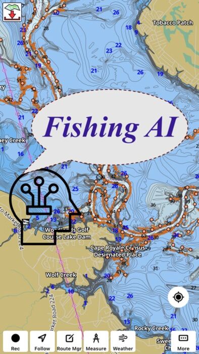
► FISHING AI
Emulates an expert angler. It is trained to include multiple variables.
√ Lake bathymetry/topography
* Point Bars
* Humps / Underwater Islands
* Channels
* Saddles
* Artificial / Man Made Structures
* River Bed
* Ledges
* Side Feeder Streams
* Pits
* And more...
√ Local Knowledge for a lake gained over the years about likely hot spots
√ Weather Patterns
√ Vegetation Maps
√ Fish Type
►FEATURES
√ Beautiful & detailed Hardware/GPU accelerated vector charts (text stays upright on rotation)
√ Long press to query the details of Marine object (Buoy,Lights,Obstruction etc).
√ Customizable depth(Ft/Fathom/Meter) & distance units(km/mi/NM)
√ Customizable Shallow Depth.
√ Record tracks,Autofollow with real-time track overlay & predicted path vector.
√ Voice Prompts for marine navigation (requires GPS )
√ 1ft / 3ft depth contour maps for anglers for selected lake maps.
√ Supports GPX/KML for boating route editing/import.
√ Tide & Currents prediction.
√ Seamless chart quilting of marine charts
√ Enter or import Waypoints.
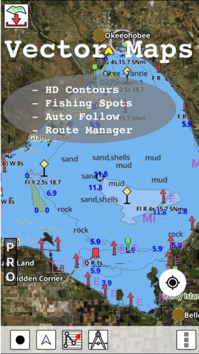
► MAPS
It includes unlimited updates for 1 year.
√ Lake Maps & Nautical Charts with Fishing Points covering US, UK,Germany, NL, AU etc.
►ROUTE MANAGEMENT / TRIP PLANNING
√ Create New Route/Edit Existing Routes
√ Move Points
√ Add points to an existing route leg
√ Delete / Rename points
√ Import GPX,KML & KMZ files
√ Plot/Edit Routes
√ Enter Waypoints
√ Share/Export Routes,Tracks&Markers
√ Reverse Routes
►GPS FEATURES
√ Auto Follow
* Real Time Track Overlay
* Predicted Path Vector
* Course Up(Text stays upright)
* Speed & Heading
√ Route Assistance With Voice Prompts
* Prompts when approaching a boating route marker
* Continous distance & ETA updates
* Alerts when sailing/boating off route
* Alerts when boating in wrong direction
√ Record Tracks
►TIDE & CURRENTS
* For US, Canada, UK, Germany & New Zealand
* High/Low Tides
* Tidal Current Prediction
* Active Current Stations
► SHARING
* Share tracks/routes/markers on Facebook & Twitter
* Export tracks/routes/markers as compressed GPX files.
Sample Charts
√ KISSIMMEE, Lake Apopka, ISTOKPOGA, SEMINOLE, TOHOPEKALIGA, Lake Tohopekaliga, HARRIS, Lakeocklawaha,
√ East Lake Tohopekaliga, Bighenderson, GRIFFIN, MONROE, TALQUIN, Lake Eustis, EUSTIS, WEOHYAKAPKA,
√ ORANGE , HARNEY, MICCOSUKEE, HATCHINEHA, SANTA FE SWAMP, Farm 13 Stick Marsh, Weir,
√ LOCHLOOSA , Crooked Lake, MARIAN, DEER POINT , HANCOCK, ROSALIE,
√ DORA, POINSETT, CROOKED , SANTA FE , RIVER STYX, Lake Yale,
√ YALE, CYPRESS , Lake Louisa, KERR, ARBUCKLE, PIERCE, June, JACKSON, PANASOFFKEE,
√ ALLIGATOR , DOCTORS , REEDY , OKAHUMPKA SWAMP, Jackson, Forest North, ROUSSEAU, MARION,
√ WASHINGTON, JOHNS , TARPON, Lake Minnehaha, HAMILTON, WOODRUFF, TIGER ,
√ DEXTER, PARKER, SAMPSON, COBB MARSH, Lake Minneola, GENTRY, DORR, BUTLER, Kingsley,
√ WINDER, TRAFFORD, BUFFUM, Josephine, TIBET, CLINCH, OKAHUMPKA,
√ LITTLE SANTA FE , ELOISE, Cherry Lake, BEAUCLAIR, MATTIE, CONWAY, SOUTH ,
√ OTTER SLOUGH, Bigsand, ASHBY, ARIANA, Hampton, CYPRESS CREEK, JULIANA, ,
PLEASE NOTE: Continued use of GPS running in the background can dramatically decrease battery life.
更新履歴
- MAJOR UPDATE
This release has two major upates:
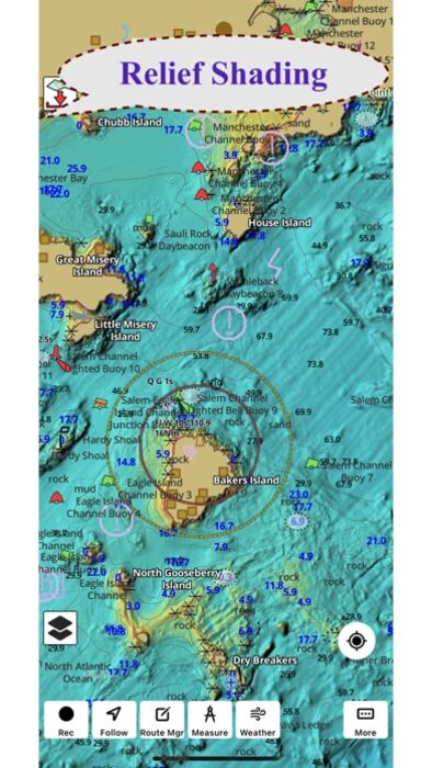
1.) Relief Shading:
i-Boating relief shading is like Google Street View, but for underwater terrain (Sea View). It's a visual representation of what the underwater terrain looks like. If you were to drain the oceans/lakes of all the water, that is the kind of view relief shading attempts to show.
2.) Lake Temperature Maps:
- Lake Temperature maps show variation in temperature accurate to 1 degree fahrenheit (0.5 degree celsius).
- Maps are color coded making it easy to identify lines where the temperature variation starts
- Easy to identify warm areas (to find the best fishing spots)
- Actual temperature text can be toggled on demand
- The application supports showing temperatures in Fahrenheit, Celsius and Kelvin
First Fishing GPS app to have route assistance with Voice Prompts for marine navigation. You can create new boating routes or import existing GPX/KML routes. It supports Nautical Charts course up orientation. Includes Tide & Currents prediction.
► FISHING AI
Emulates an expert angler. It is trained to include multiple variables.
√ Lake bathymetry/topography
* Point Bars
* Humps / Underwater Islands
* Channels
* Saddles
* Artificial / Man Made Structures
* River Bed
* Ledges
* Side Feeder Streams
* Pits
* And more...
√ Local Knowledge for a lake gained over the years about likely hot spots
√ Weather Patterns
√ Vegetation Maps
√ Fish Type
►FEATURES
√ Beautiful & detailed Hardware/GPU accelerated vector charts (text stays upright on rotation)
√ Long press to query the details of Marine object (Buoy,Lights,Obstruction etc).
√ Customizable depth(Ft/Fathom/Meter) & distance units(km/mi/NM)
√ Customizable Shallow Depth.
√ Record tracks,Autofollow with real-time track overlay & predicted path vector.
√ Voice Prompts for marine navigation (requires GPS )
√ 1ft / 3ft depth contour maps for anglers for selected lake maps.
√ Supports GPX/KML for boating route editing/import.
√ Tide & Currents prediction.
√ Seamless chart quilting of marine charts
√ Enter or import Waypoints.
► MAPS
It includes unlimited updates for 1 year.
√ Lake Maps & Nautical Charts with Fishing Points covering US, UK,Germany, NL, AU etc.
►ROUTE MANAGEMENT / TRIP PLANNING
√ Create New Route/Edit Existing Routes
√ Move Points
√ Add points to an existing route leg
√ Delete / Rename points
√ Import GPX,KML & KMZ files
√ Plot/Edit Routes
√ Enter Waypoints
√ Share/Export Routes,Tracks&Markers
√ Reverse Routes
►GPS FEATURES
√ Auto Follow
* Real Time Track Overlay
* Predicted Path Vector
* Course Up(Text stays upright)
* Speed & Heading
√ Route Assistance With Voice Prompts
* Prompts when approaching a boating route marker
* Continous distance & ETA updates
* Alerts when sailing/boating off route
* Alerts when boating in wrong direction
√ Record Tracks
►TIDE & CURRENTS
* For US, Canada, UK, Germany & New Zealand
* High/Low Tides
* Tidal Current Prediction
* Active Current Stations
► SHARING
* Share tracks/routes/markers on Facebook & Twitter
* Export tracks/routes/markers as compressed GPX files.
Sample Charts
√ KISSIMMEE, Lake Apopka, ISTOKPOGA, SEMINOLE, TOHOPEKALIGA, Lake Tohopekaliga, HARRIS, Lakeocklawaha,
√ East Lake Tohopekaliga, Bighenderson, GRIFFIN, MONROE, TALQUIN, Lake Eustis, EUSTIS, WEOHYAKAPKA,
√ ORANGE , HARNEY, MICCOSUKEE, HATCHINEHA, SANTA FE SWAMP, Farm 13 Stick Marsh, Weir,
√ LOCHLOOSA , Crooked Lake, MARIAN, DEER POINT , HANCOCK, ROSALIE,
√ DORA, POINSETT, CROOKED , SANTA FE , RIVER STYX, Lake Yale,
√ YALE, CYPRESS , Lake Louisa, KERR, ARBUCKLE, PIERCE, June, JACKSON, PANASOFFKEE,
√ ALLIGATOR , DOCTORS , REEDY , OKAHUMPKA SWAMP, Jackson, Forest North, ROUSSEAU, MARION,
√ WASHINGTON, JOHNS , TARPON, Lake Minnehaha, HAMILTON, WOODRUFF, TIGER ,
√ DEXTER, PARKER, SAMPSON, COBB MARSH, Lake Minneola, GENTRY, DORR, BUTLER, Kingsley,
√ WINDER, TRAFFORD, BUFFUM, Josephine, TIBET, CLINCH, OKAHUMPKA,
√ LITTLE SANTA FE , ELOISE, Cherry Lake, BEAUCLAIR, MATTIE, CONWAY, SOUTH ,
√ OTTER SLOUGH, Bigsand, ASHBY, ARIANA, Hampton, CYPRESS CREEK, JULIANA, ,
PLEASE NOTE: Continued use of GPS running in the background can dramatically decrease battery life.
更新履歴
- MAJOR UPDATE
This release has two major upates:
1.) Relief Shading:
i-Boating relief shading is like Google Street View, but for underwater terrain (Sea View). It's a visual representation of what the underwater terrain looks like. If you were to drain the oceans/lakes of all the water, that is the kind of view relief shading attempts to show.
2.) Lake Temperature Maps:
- Lake Temperature maps show variation in temperature accurate to 1 degree fahrenheit (0.5 degree celsius).
- Maps are color coded making it easy to identify lines where the temperature variation starts
- Easy to identify warm areas (to find the best fishing spots)
- Actual temperature text can be toggled on demand
- The application supports showing temperatures in Fahrenheit, Celsius and Kelvin
ブログパーツ第二弾を公開しました!ホームページでアプリの順位・価格・周辺ランキングをご紹介頂けます。
ブログパーツ第2弾!
アプリの周辺ランキングを表示するブログパーツです。価格・順位共に自動で最新情報に更新されるのでアプリの状態チェックにも最適です。
ランキング圏外の場合でも周辺ランキングの代わりに説明文を表示にするので安心です。
サンプルが気に入りましたら、下に表示されたHTMLタグをそのままページに貼り付けることでご利用頂けます。ただし、一般公開されているページでご使用頂かないと表示されませんのでご注意ください。
幅200px版
幅320px版
お気に入りのアプリをご紹介頂くためのブログパーツです。アプリの価格や順位表示は毎日自動更新♪
サンプルが気に入りましたら、下に表示されたHTMLタグをそのままページに貼り付けることでご利用頂けます。
※配信を停止させていただく可能性もございますので、タグの改変はご遠慮ください。

Now Loading...

「iPhone & iPad アプリランキング」は、最新かつ詳細なアプリ情報をご紹介しているサイトです。
お探しのアプリに出会えるように様々な切り口でページをご用意しております。
「メニュー」よりぜひアプリ探しにお役立て下さい。
Presents by $$308413110 スマホからのアクセスにはQRコードをご活用ください。 →
Now loading...