Bruce Peninsula NP HD GPS charts Navigator |
| このアプリは現在ストアで閲覧することができません。 | ||||


|
価格 | 610円 | ダウンロード |
|
|---|---|---|---|---|
| ジャンル | ナビゲーション | |||
サイズ | 28.6MB | |||
| 開発者 | Flytomap | |||
| 順位 |
| |||
| リリース日 | 2017-01-21 01:50:24 | 評価 | 評価が取得できませんでした。 | |
| 互換性 | iOS 9.0以降が必要です。 iPhone、iPad および iPod touch 対応。 | |||
|
||||
Bruce Peninsula coverage resident in the app. It works WITHOUT mobile coverage!
• Worldwide Flytomap Charts available when connected, thanks to viewer.flytomap.com
• Worldwide Satellite images overlay on charts
• Worldwide Terrain features overlay on charts, thanks to Open Street Map, Open Cycle Map, Bing,Earth,Topo Chart and GMap
• Local Weather forecast
This app is extremely advanced and contains embedded electronic charts with all information collected from the National Park Service [NPS] and local sources. The maps contain multiple trails (Hiking, biking, Stairway trails, Bicycle trails, Equestrian trails etc.,) and Points of interest (POI) like Campgrounds, Eating places, Ranger Stations, Picnic areas, Boat/Canoe launching, Parking areas etc.,
“Covers all Trails, Lakes and Rivers within the Parks”
“Covers complete park boundary from [NPS]”
“Elevation Contours with 10 meters interval”
“Mountain Summits”
“All Roads and Railways”
Use to Explore:
√ Latitudes and Longitudes to go to your favorite places
√ Search your Favorite points directly
√ Zoom, Rotate and Pan fast just by a finger touch
√ Quick Object information just tapping, thanks to vector technology
√ GPS Heading Vector Towards the direction movement
√ Distance Measurement Tool to easily calculate the distance from one location to another
√ Route planning, Waypoints - Insert the target/destination and see in real time your speed, distance and bearing
√ Magnified Lens for all info
√ Unlimited Tracks, Markers, Geo-tagged photos, records and share via email, visible on Google, Flytomap Viewer, KMZ format - Store your track without the need of cellular data or mobile signal
√ a la carte menu
√ Quick Waypoint
√ iOS background mode - Flytomap works in background as well, you can swap with another app and receive/make calls send sms while track recording.
√ Optimized battery usage
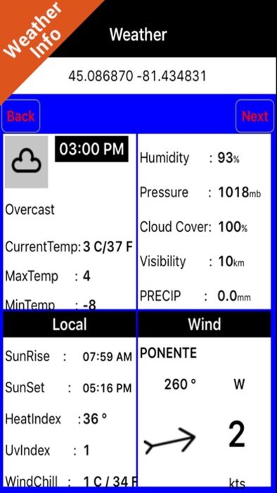
√ Worldwide Weather forecast at a quick tap provides you:
• Day max and min temperature - Current temperature
• Wind Speed and direction
• Weather description
• Precipitation & Humidity
• Visibility
• Cloud cover in percentage
• Wind chill/Feels like Temperature
• Heat Index Temperature
• UvIndex
• Pressure
• SunRise & SunSet
√ And so much more to come - It’s the only app you will ever need! Our charts are installed on: GARMIN NAVICO LOWRANCE ENDURA B&G EAGLE SIMRAD
Follow us:
▶Twitter @flytomap
▶Web Site flytomap.com
▶Web App viewer.flytomap.com
▶Facebook facebook.com/flytomap
Flytomap is committed to constant improvement, this App is developed with the help of professionals to get the best outdoor experience, we listen to our users and systematically add the most requested features.
Thank you for the feedback!
"Continued use of GPS running in the background can dramatically decrease battery life."
更新履歴
This app has been updated by Apple to use the latest Apple signing certificate.
Track improvement
Marine Weather algorithm update
• Worldwide Flytomap Charts available when connected, thanks to viewer.flytomap.com
• Worldwide Satellite images overlay on charts
• Worldwide Terrain features overlay on charts, thanks to Open Street Map, Open Cycle Map, Bing,Earth,Topo Chart and GMap
• Local Weather forecast
This app is extremely advanced and contains embedded electronic charts with all information collected from the National Park Service [NPS] and local sources. The maps contain multiple trails (Hiking, biking, Stairway trails, Bicycle trails, Equestrian trails etc.,) and Points of interest (POI) like Campgrounds, Eating places, Ranger Stations, Picnic areas, Boat/Canoe launching, Parking areas etc.,
“Covers all Trails, Lakes and Rivers within the Parks”
“Covers complete park boundary from [NPS]”
“Elevation Contours with 10 meters interval”
“Mountain Summits”
“All Roads and Railways”
Use to Explore:
√ Latitudes and Longitudes to go to your favorite places
√ Search your Favorite points directly
√ Zoom, Rotate and Pan fast just by a finger touch
√ Quick Object information just tapping, thanks to vector technology
√ GPS Heading Vector Towards the direction movement
√ Distance Measurement Tool to easily calculate the distance from one location to another
√ Route planning, Waypoints - Insert the target/destination and see in real time your speed, distance and bearing
√ Magnified Lens for all info
√ Unlimited Tracks, Markers, Geo-tagged photos, records and share via email, visible on Google, Flytomap Viewer, KMZ format - Store your track without the need of cellular data or mobile signal
√ a la carte menu
√ Quick Waypoint
√ iOS background mode - Flytomap works in background as well, you can swap with another app and receive/make calls send sms while track recording.
√ Optimized battery usage
√ Worldwide Weather forecast at a quick tap provides you:
• Day max and min temperature - Current temperature
• Wind Speed and direction
• Weather description
• Precipitation & Humidity
• Visibility
• Cloud cover in percentage
• Wind chill/Feels like Temperature
• Heat Index Temperature
• UvIndex
• Pressure
• SunRise & SunSet
√ And so much more to come - It’s the only app you will ever need! Our charts are installed on: GARMIN NAVICO LOWRANCE ENDURA B&G EAGLE SIMRAD
Follow us:
▶Twitter @flytomap
▶Web Site flytomap.com
▶Web App viewer.flytomap.com
▶Facebook facebook.com/flytomap
Flytomap is committed to constant improvement, this App is developed with the help of professionals to get the best outdoor experience, we listen to our users and systematically add the most requested features.
Thank you for the feedback!
"Continued use of GPS running in the background can dramatically decrease battery life."
更新履歴
This app has been updated by Apple to use the latest Apple signing certificate.
Track improvement
Marine Weather algorithm update
ブログパーツ第二弾を公開しました!ホームページでアプリの順位・価格・周辺ランキングをご紹介頂けます。
ブログパーツ第2弾!
アプリの周辺ランキングを表示するブログパーツです。価格・順位共に自動で最新情報に更新されるのでアプリの状態チェックにも最適です。
ランキング圏外の場合でも周辺ランキングの代わりに説明文を表示にするので安心です。
サンプルが気に入りましたら、下に表示されたHTMLタグをそのままページに貼り付けることでご利用頂けます。ただし、一般公開されているページでご使用頂かないと表示されませんのでご注意ください。
幅200px版
幅320px版
お気に入りのアプリをご紹介頂くためのブログパーツです。アプリの価格や順位表示は毎日自動更新♪
サンプルが気に入りましたら、下に表示されたHTMLタグをそのままページに貼り付けることでご利用頂けます。
※配信を停止させていただく可能性もございますので、タグの改変はご遠慮ください。

Now Loading...

「iPhone & iPad アプリランキング」は、最新かつ詳細なアプリ情報をご紹介しているサイトです。
お探しのアプリに出会えるように様々な切り口でページをご用意しております。
「メニュー」よりぜひアプリ探しにお役立て下さい。
Presents by $$308413110 スマホからのアクセスにはQRコードをご活用ください。 →
Now loading...